Property Record
100 N Jackrabbit Trl, Buckeye, AZ 85326
NEARBY LISTINGS FOR SALE OR LEASE
Property Detail
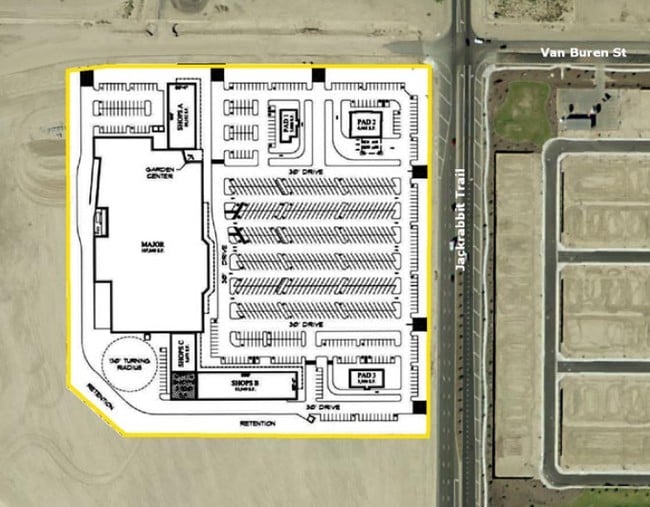
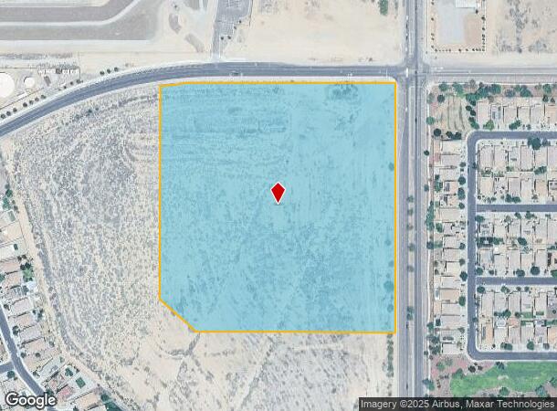
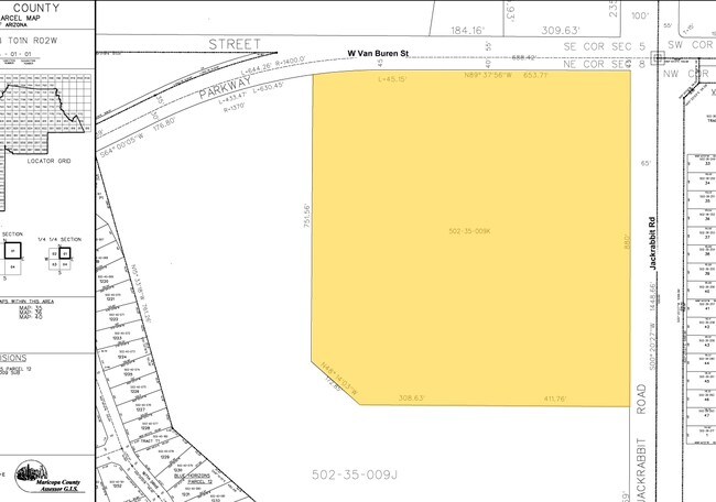
100 N Jackrabbit Trl
502-35-009K
PT NE4 SEC 8 DAF COM NE COR SD SEC TH S 44.97F TH W 65F TO POB TH S 880F TH W 720.39F TH N 48D 14M W 172.85F TH N 751.56F TO BEG NON-TAN CUR RAD BEARS S 07D 52M E 1370F TH ELY ALG SD CUR A DIST OF 196.99F TH E 653.68F TO POB
Commercialacreage
Maricopa
X
Arizona
04013C2130L
16.98 AC
2025
West I-10
2025
Phoenix
050611
Phoenix-Mesa-Chandler, AZ
DEMOGRAPHICS near 100 N Jackrabbit Trl
1 mile
3 mile
5 mile
2024 Total Population
8,382
43,614
118,106
2029 Population
9,438
48,566
131,477
Pop Growth 2024-2029
+ 12.60%
+ 11.35%
+ 11.32%
Average Age
32
34
38
2024 Total Households
2,523
12,881
37,439
HH Growth 2024-2029
+ 12.68%
+ 11.40%
+ 11.54%
Median Household Inc
$89,975
$99,355
$98,356
Avg Household Size
3.20
3.30
3.10
2024 Avg HH Vehicles
2.00
2.00
2.00
Median Home Value
$307,618
$371,549
$393,205
Median Year Built
2011
2010
2010
Nearby Places
Map Layers
Map Styles
 Street
 Aerial
Transit
 Traffic
 Biking
Places
Listings with unknown addresses are not visible on the map
- Restaurants
- Banks
- Shops
- Fitness
- Groceries
PUBLIC TRANSPORTATION
AIRPORT
Phoenix Sky Harbor International
Drive
Walk
Distance
Phoenix Sky Harbor International
40 min
30.8 mi
Freight Ports
Port of San Diego
Drive
Walk
Distance
Port of San Diego
369 min
332.4 mi
SALE & LEASE HISTORY
LISTING DATE
SALE/LEASE

Feb 14, 2017
For Sale
Feb 04, 2022
For Sale
Nearby Properties
Address
Land Use
TOTAL SIZE
Lot Size
Zoning
Address
Land Use
TOTAL SIZE
Lot Size
Zoning
551,831 SF
609.49 AC
AG
Address
Land Use
TOTAL SIZE
Lot Size
Zoning
196,353 SF
13.05 AC
C-C
Address
Land Use
TOTAL SIZE
Lot Size
Zoning
239,259 SF
22.68 AC
PAD
Address
Land Use
TOTAL SIZE
Lot Size
Zoning
179,632 SF
16.64 AC
PR
Address
Land Use
TOTAL SIZE
Lot Size
Zoning
226,139 SF
19.46 AC
PAD
Address
Land Use
TOTAL SIZE
Lot Size
Zoning
152,901 SF
22.52 AC
Address
Land Use
TOTAL SIZE
Lot Size
Zoning
1.98 AC
PAD
Address
Land Use
TOTAL SIZE
Lot Size
Zoning
156,060 SF
12.04 AC
R-43
Address
Land Use
TOTAL SIZE
Lot Size
Zoning
254,903 SF
26.70 AC
Address
Land Use
TOTAL SIZE
Lot Size
Zoning
82,692 SF
23.68 AC
Address
Land Use
TOTAL SIZE
Lot Size
Zoning
73,130 SF
3.68 AC
PAD
Address
Land Use
TOTAL SIZE
Lot Size
Zoning
12,418 SF
54.25 AC
PC
Address
Land Use
TOTAL SIZE
Lot Size
Zoning
91,505 SF
16.57 AC
PAD
Address
Land Use
TOTAL SIZE
Lot Size
Zoning
80,531 SF
7.51 AC
PAD
Address
Land Use
TOTAL SIZE
Lot Size
Zoning
40,300 SF
19.53 AC
CC
Address
Land Use
TOTAL SIZE
Lot Size
Zoning
138.68 AC
Address
Land Use
TOTAL SIZE
Lot Size
Zoning
44,463 SF
79.72 AC
RR
Address
Land Use
TOTAL SIZE
Lot Size
Zoning
5,597 SF
164.45 AC
PR
Address
Land Use
TOTAL SIZE
Lot Size
Zoning
64,720 SF
2.24 AC
PC
Address
Land Use
TOTAL SIZE
Lot Size
Zoning
34,356 SF
14.43 AC
CC
Address
Land Use
TOTAL SIZE
Lot Size
Zoning
81,314 SF
37.67 AC
PAD
Address
Land Use
TOTAL SIZE
Lot Size
Zoning
39.31 AC
Address
Land Use
TOTAL SIZE
Lot Size
Zoning
33,775 SF
7.68 AC
PAD
Address
Land Use
TOTAL SIZE
Lot Size
Zoning
3,811 SF
4.69 AC
R-43
Address
Land Use
TOTAL SIZE
Lot Size
Zoning
51,512 SF
18.71 AC
I-1
Address
Land Use
TOTAL SIZE
Lot Size
Zoning
65,023 SF
12.52 AC
C-C
Address
Land Use
TOTAL SIZE
Lot Size
Zoning
65,506 SF
5 AC
C-C
Address
Land Use
TOTAL SIZE
Lot Size
Zoning
52.66 AC
The World's #1 Commercial Real Estate Marketplace
Connect with us
© 2026 CoStar Group
The information above has been obtained from sources believed reliable. While we do not doubt its accuracy we have not verified it and make no guarantee, warranty or representation about it. It is your responsibility to independently confirm its accuracy and completeness. Any projections, opinions, assumptions, or estimates used are for example only and do not represent the current or future performance of the property. The value of this transaction to you depends on tax and other factors which should be evaluated by your tax, financial, and legal advisors. You and your advisors should conduct a careful, independent investigation of the property to determine to your satisfaction the suitability of the property for your needs.