Property Record
100 Parkview Dr, Kittanning, PA 16201


Save to a Folder
{{folder.Name}}
{{folder.ListingIds.length}} Properties
{{folder.ListingIds.length}} Property
Create a New Folder
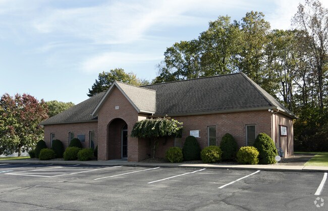
Property Detail
100 Parkview Dr
Pittsburgh, PA
MAP NO:117.00-02-51.001- ; LOT 1 - IMPRS. PB5 PG670
12-0-067110
Armstrong
Officebuilding
Pennsylvania
B and X Area of moderate flood hazard, usually the area between the limits of the 100-year and 500-year floods.
1
2026
1.10 AC
2026
Armstrong County
950500
Pittsburgh
1,980 SF
NEARBY LISTINGS FOR SALE OR LEASE
DEMOGRAPHICS near 100 Parkview Dr
1 mile
3 mile
5 mile
2025 Total Population
683
10,140
21,291
2030 Population
665
9,920
20,869
Pop Growth 2025-2030
(2.64%)
(2.17%)
(1.98%)
Average Age
46
45
45
2025 Total Households
285
4,486
9,410
HH Growth 2025-2030
(2.81%)
(2.21%)
(2.06%)
Median Household Inc
$91,611
$65,264
$65,384
Avg Household Size
2.30
2.20
2.20
2025 Avg HH Vehicles
2.00
2.00
2.00
Median Home Value
$205,435
$162,893
$149,734
Median Year Built
1981
1957
1956
Nearby Places
Map Layers
Map Styles
 Street
 Aerial
Layers
 Traffic
 Biking
Places
Listings with unknown addresses are not visible on the map
- Restaurants
- Banks
- Shops
- Fitness
- Groceries
SALE & LEASE HISTORY
LISTING DATE
SALE/LEASE

Nov 02, 2018
For Lease
May 01, 2018
For Lease
Aug 10, 2017
For Lease
Nearby Properties
Address
Land Use
TOTAL SIZE
Lot Size
Zoning
Address
Land Use
TOTAL SIZE
Lot Size
Zoning
233,203 SF
9.93 AC
Address
Land Use
TOTAL SIZE
Lot Size
Zoning
145,792 SF
13.04 AC
COMMERCIAL
Address
Land Use
TOTAL SIZE
Lot Size
Zoning
37,066 SF
60.59 AC
Address
Land Use
TOTAL SIZE
Lot Size
Zoning
79,630 SF
109.35 AC
RESIDENTIA
Address
Land Use
TOTAL SIZE
Lot Size
Zoning
31,984 SF
0.79 AC
BUSINESS
Address
Land Use
TOTAL SIZE
Lot Size
Zoning
27,200 SF
5.99 AC
INDUSTRIAL
Address
Land Use
TOTAL SIZE
Lot Size
Zoning
96,646 SF
7.90 AC
COMMERCIAL
Address
Land Use
TOTAL SIZE
Lot Size
Zoning
42,795 SF
7.89 AC
INDUSTRIAL
Address
Land Use
TOTAL SIZE
Lot Size
Zoning
113,651 SF
4.49 AC
Address
Land Use
TOTAL SIZE
Lot Size
Zoning
42,238 SF
1.50 AC
PUBLIC
Address
Land Use
TOTAL SIZE
Lot Size
Zoning
31,290 SF
2.93 AC
COMMERCIAL
Address
Land Use
TOTAL SIZE
Lot Size
Zoning
89,326 SF
1.01 AC
PUBLIC
Address
Land Use
TOTAL SIZE
Lot Size
Zoning
72,840 SF
1.08 AC
RESIDENTIA
Address
Land Use
TOTAL SIZE
Lot Size
Zoning
36,441 SF
22.55 AC
COMMERCIAL
Address
Land Use
TOTAL SIZE
Lot Size
Zoning
83,216 SF
1.15 AC
PUBLIC
Address
Land Use
TOTAL SIZE
Lot Size
Zoning
28,431 SF
1.26 AC
Address
Land Use
TOTAL SIZE
Lot Size
Zoning
65,038 SF
0.91 AC
PUBLIC
Address
Land Use
TOTAL SIZE
Lot Size
Zoning
31,104 SF
7.22 AC
Address
Land Use
TOTAL SIZE
Lot Size
Zoning
35,940 SF
24.59 AC
COMMERCIAL
Address
Land Use
TOTAL SIZE
Lot Size
Zoning
13,440 SF
3.68 AC
RESIDENTIA
Address
Land Use
TOTAL SIZE
Lot Size
Zoning
29,456 SF
3.70 AC
Address
Land Use
TOTAL SIZE
Lot Size
Zoning
14,604 SF
0.78 AC
Address
Land Use
TOTAL SIZE
Lot Size
Zoning
54,048 SF
4.04 AC
COMMERCIAL
Address
Land Use
TOTAL SIZE
Lot Size
Zoning
12,146 SF
6.87 AC
Address
Land Use
TOTAL SIZE
Lot Size
Zoning
10,788 SF
38.72 AC
Address
Land Use
TOTAL SIZE
Lot Size
Zoning
30,720 SF
1.23 AC
Address
Land Use
TOTAL SIZE
Lot Size
Zoning
51,284 SF
7 AC
INDUSTRIAL
Address
Land Use
TOTAL SIZE
Lot Size
Zoning
18,304 SF
209.96 AC
Address
Land Use
TOTAL SIZE
Lot Size
Zoning
19,800 SF
5.80 AC
INDUSTRIAL
Address
Land Use
TOTAL SIZE
Lot Size
Zoning
7,292 SF
5.20 AC
The World's #1 Commercial Real Estate Marketplace
Connect with us
© 2026 CoStar Group
The information above has been obtained from sources believed reliable. While we do not doubt its accuracy we have not verified it and make no guarantee, warranty or representation about it. It is your responsibility to independently confirm its accuracy and completeness. Any projections, opinions, assumptions, or estimates used are for example only and do not represent the current or future performance of the property. The value of this transaction to you depends on tax and other factors which should be evaluated by your tax, financial, and legal advisors. You and your advisors should conduct a careful, independent investigation of the property to determine to your satisfaction the suitability of the property for your needs.