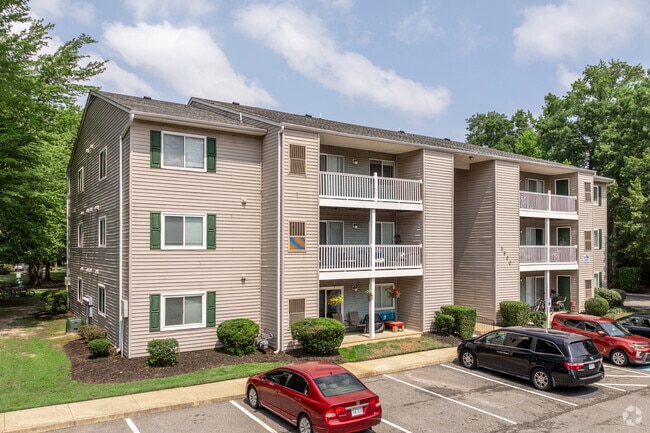
Property Record
100 Piccadilly Loop, Yorktown, VA 23692

Save to a Folder
{{folder.Name}}
{{folder.ListingIds.length}} Properties
{{folder.ListingIds.length}} Property
Create a New Folder
Property Detail
100 Piccadilly Loop
S06D-2776-2493
PLAT OF 1991 ASHE PARTNERSHIP
Apartment
York
MULTI-FAMI
Virginia
B and X Area of moderate flood hazard, usually the area between the limits of the 100-year and 500-year floods.
17.21 AC
2025
York County
2026
Hampton Roads
050303
Virginia Beach-Chesapeake-Norfolk, VA-NC
252 SF
NEARBY LISTINGS FOR SALE OR LEASE
-
-
View all Yorktown listings for sale on LoopNet.com
DEMOGRAPHICS near 100 Piccadilly Loop
1 mile
3 mile
5 mile
2025 Total Population
6,543
30,146
119,837
2030 Population
6,530
30,103
119,120
Pop Growth 2025-2030
(0.20%)
(0.14%)
(0.60%)
Average Age
41
43
39
2025 Total Households
2,622
11,824
47,904
HH Growth 2025-2030
(0.31%)
(0.23%)
(0.66%)
Median Household Inc
$94,015
$106,255
$83,636
Avg Household Size
2.50
2.50
2.50
2025 Avg HH Vehicles
2.00
2.00
2.00
Median Home Value
$397,544
$412,811
$365,243
Median Year Built
1988
1987
1987
Nearby Places
Map Layers
Map Styles
 Street
 Aerial
Layers
 Traffic
 Biking
Places
Listings with unknown addresses are not visible on the map
- Restaurants
- Banks
- Shops
- Fitness
- Groceries
PUBLIC TRANSPORTATION
AIRPORT
Newport News/Williamsburg International
Drive
Walk
Distance
Newport News/Williamsburg International
12 min
5.8 mi
Norfolk International
Drive
Walk
Distance
Norfolk International
44 min
28.6 mi
Nearby Properties
Address
Land Use
TOTAL SIZE
Lot Size
Zoning
Address
Land Use
TOTAL SIZE
Lot Size
Zoning
39,492 SF
798.51 AC
RESOURCE C
Address
Land Use
TOTAL SIZE
Lot Size
Zoning
297,617 SF
50.90 AC
RC,GB
Address
Land Use
TOTAL SIZE
Lot Size
Zoning
197,355 SF
10.89 AC
R8
Address
Land Use
TOTAL SIZE
Lot Size
Zoning
5.04 AC
R9
Address
Land Use
TOTAL SIZE
Lot Size
Zoning
97,180 SF
53.17 AC
C1
Address
Land Use
TOTAL SIZE
Lot Size
Zoning
290,802 SF
29.47 AC
RMF,GB
Address
Land Use
TOTAL SIZE
Lot Size
Zoning
156 SF
19.99 AC
MULTI-FAMI
Address
Land Use
TOTAL SIZE
Lot Size
Zoning
184,845 SF
9.17 AC
GENERAL BU
Address
Land Use
TOTAL SIZE
Lot Size
Zoning
10,000 SF
9.10 AC
PLANNED DE
Address
Land Use
TOTAL SIZE
Lot Size
Zoning
96,438 SF
15 AC
P1
Address
Land Use
TOTAL SIZE
Lot Size
Zoning
201,289 SF
28.82 AC
GB,R20
Address
Land Use
TOTAL SIZE
Lot Size
Zoning
56,654 SF
12.03 AC
LIMITED IN
Address
Land Use
TOTAL SIZE
Lot Size
Zoning
57,036 SF
9.68 AC
GENERAL BU
Address
Land Use
TOTAL SIZE
Lot Size
Zoning
159,125 SF
29.38 AC
RESOURCE C
Address
Land Use
TOTAL SIZE
Lot Size
Zoning
50,744 SF
53.12 AC
LIMITED IN
Address
Land Use
TOTAL SIZE
Lot Size
Zoning
39,411 SF
8.23 AC
GENERAL BU
Address
Land Use
TOTAL SIZE
Lot Size
Zoning
87,160 SF
19.68 AC
RESOURCE C
Address
Land Use
TOTAL SIZE
Lot Size
Zoning
7,275 SF
18.02 AC
IL,GB
Address
Land Use
TOTAL SIZE
Lot Size
Zoning
88,170 SF
7.91 AC
LIMITED BU
Address
Land Use
TOTAL SIZE
Lot Size
Zoning
102,942 SF
7.34 AC
R8
Address
Land Use
TOTAL SIZE
Lot Size
Zoning
97,934 SF
26.70 AC
RESOURCE C
Address
Land Use
TOTAL SIZE
Lot Size
Zoning
85,727 SF
11.76 AC
GB,R20
Address
Land Use
TOTAL SIZE
Lot Size
Zoning
930.01 AC
RESOURCE C
Address
Land Use
TOTAL SIZE
Lot Size
Zoning
48,272 SF
5 AC
GENERAL BU
Address
Land Use
TOTAL SIZE
Lot Size
Zoning
19,763 SF
2.98 AC
GENERAL BU
Address
Land Use
TOTAL SIZE
Lot Size
Zoning
255 SF
76.13 AC
M1
Address
Land Use
TOTAL SIZE
Lot Size
Zoning
58,005 SF
6.85 AC
GENERAL BU
Address
Land Use
TOTAL SIZE
Lot Size
Zoning
68,151 SF
15.72 AC
RESOURCE C
Address
Land Use
TOTAL SIZE
Lot Size
Zoning
49,305 SF
2.29 AC
GENERAL BU
The World's #1 Commercial Real Estate Marketplace
Connect with us
© 2026 CoStar Group
The information above has been obtained from sources believed reliable. While we do not doubt its accuracy we have not verified it and make no guarantee, warranty or representation about it. It is your responsibility to independently confirm its accuracy and completeness. Any projections, opinions, assumptions, or estimates used are for example only and do not represent the current or future performance of the property. The value of this transaction to you depends on tax and other factors which should be evaluated by your tax, financial, and legal advisors. You and your advisors should conduct a careful, independent investigation of the property to determine to your satisfaction the suitability of the property for your needs.