Property Record
100 Preston St, Hartford, CT 06114
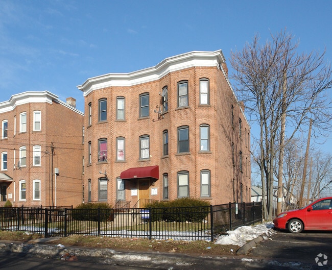
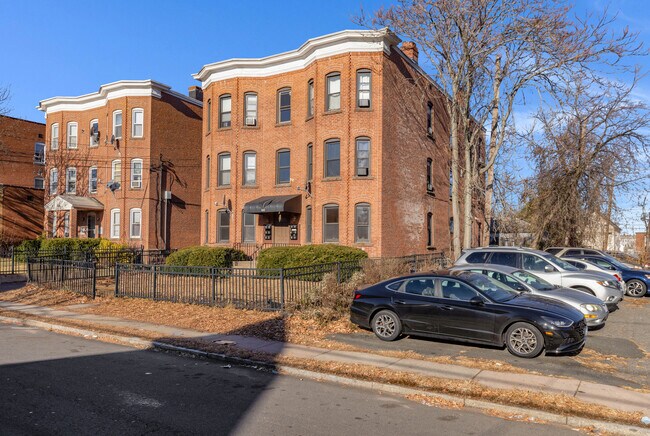
This Property Is For Sale
NEARBY LISTINGS FOR SALE OR LEASE
Property Detail
100 Preston St
Taxexempt
Hartford
X
Connecticut
09003C0506G
336
0
South End
2025
Hartford
502400
Hartford-West Hartford-East Hartford, CT
850 SF
HTFD M:999 B:999 L:336
DEMOGRAPHICS near 100 Preston St
1 Mile
3 Mile
5 Mile
2024 Total Population
27,274
140,894
275,056
2029 Population
26,821
140,323
273,484
Pop Growth 2024-2029
(1.66%)
(0.41%)
(0.57%)
Average Age
36
38
39
2024 Total Households
9,622
58,558
111,315
HH Growth 2024-2029
(1.80%)
(0.21%)
(0.49%)
Median Household Inc
$41,858
$49,134
$63,120
Avg Household Size
2.60
2.30
2.30
2024 Avg HH Vehicles
1.00
1.00
1.00
Median Home Value
$222,858
$217,032
$253,833
Median Year Built
1947
1953
1956
Nearby Places
- Restaurants
- Banks
- Shops
- Fitness
- Groceries
PUBLIC TRANSPORTATION
AIRPORT
Bradley International
DRIVE
WALK
Distance
Bradley International
56 min
31.8 mi
Tweed/New Haven
DRIVE
WALK
Distance
Tweed/New Haven
49 min
32.8 mi
Freight Ports
Port of New Haven
DRIVE
WALK
Distance
Port of New Haven
45 min
30.5 mi
Nearby Properties
Address
Land Use
TOTAL SIZE
Lot Size
Zoning
Address
Land Use
TOTAL SIZE
Lot Size
Zoning
77,001 SF
54.59 AC
IP-1
Address
Land Use
TOTAL SIZE
Lot Size
Zoning
349,054 SF
12.03 AC
R-15
Address
Land Use
TOTAL SIZE
Lot Size
Zoning
139 AC
IP-25
Address
Land Use
TOTAL SIZE
Lot Size
Zoning
58,473 SF
18.20 AC
IP-1
Address
Land Use
TOTAL SIZE
Lot Size
Zoning
145,719 SF
17.90 AC
R-15
Address
Land Use
TOTAL SIZE
Lot Size
Zoning
121,917 SF
28.60 AC
R-15
Address
Land Use
TOTAL SIZE
Lot Size
Zoning
114,375 SF
12.72 AC
IP-1
Address
Land Use
TOTAL SIZE
Lot Size
Zoning
330,400 SF
36.90 AC
IP-1
Address
Land Use
TOTAL SIZE
Lot Size
Zoning
12,892 SF
20.91 AC
A
Address
Land Use
TOTAL SIZE
Lot Size
Zoning
56,184 SF
19.42 AC
BG
Address
Land Use
TOTAL SIZE
Lot Size
Zoning
171,826 SF
36.60 AC
R-15
Address
Land Use
TOTAL SIZE
Lot Size
Zoning
199,744 SF
44.70 AC
R-15
Address
Land Use
TOTAL SIZE
Lot Size
Zoning
62,232 SF
0.90 AC
BD-1
Address
Land Use
TOTAL SIZE
Lot Size
Zoning
169,727 SF
23.90 AC
R-25
Address
Land Use
TOTAL SIZE
Lot Size
Zoning
54,904 SF
7.01 AC
A
Address
Land Use
TOTAL SIZE
Lot Size
Zoning
133,673 SF
30.40 AC
R-40
Address
Land Use
TOTAL SIZE
Lot Size
Zoning
4,000 SF
13.78 AC
BG
Address
Land Use
TOTAL SIZE
Lot Size
Zoning
120,801 SF
8.35 AC
R-40
Address
Land Use
TOTAL SIZE
Lot Size
Zoning
3,084 SF
14.90 AC
BG
Address
Land Use
TOTAL SIZE
Lot Size
Zoning
133,720 SF
7.34 AC
IP-1
Address
Land Use
TOTAL SIZE
Lot Size
Zoning
42,516 SF
10.40 AC
BG
Address
Land Use
TOTAL SIZE
Lot Size
Zoning
118,573 SF
9.75 AC
BG
Address
Land Use
TOTAL SIZE
Lot Size
Zoning
51,851 SF
1.32 AC
BD-1
Address
Land Use
TOTAL SIZE
Lot Size
Zoning
52,128 SF
7.20 AC
A
Address
Land Use
TOTAL SIZE
Lot Size
Zoning
1,250 SF
14.90 AC
I
Address
Land Use
TOTAL SIZE
Lot Size
Zoning
47,218 SF
3.62 AC
BD-1
Address
Land Use
TOTAL SIZE
Lot Size
Zoning
4,209 SF
14.60 AC
A
Address
Land Use
TOTAL SIZE
Lot Size
Zoning
80,776 SF
2.49 AC
BD-1
Address
Land Use
TOTAL SIZE
Lot Size
Zoning
60,935 SF
0.92 AC
BD-1
Address
Land Use
TOTAL SIZE
Lot Size
Zoning
134,955 SF
3.30 AC
BD-2
The World's #1 Commercial Real Estate Marketplace
Connect with us
© 2025 CoStar Group
The information above has been obtained from sources believed reliable. While we do not doubt its accuracy we have not verified it and make no guarantee, warranty or representation about it. It is your responsibility to independently confirm its accuracy and completeness. Any projections, opinions, assumptions, or estimates used are for example only and do not represent the current or future performance of the property. The value of this transaction to you depends on tax and other factors which should be evaluated by your tax, financial, and legal advisors. You and your advisors should conduct a careful, independent investigation of the property to determine to your satisfaction the suitability of the property for your needs.