Property Record
100 Prosperity Ave Se, Albuquerque, NM 87105
NEARBY LISTINGS FOR SALE OR LEASE
Property Detail
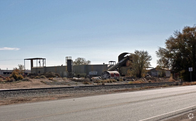
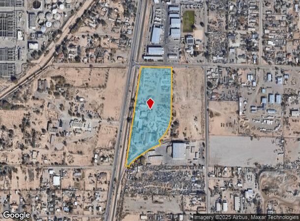
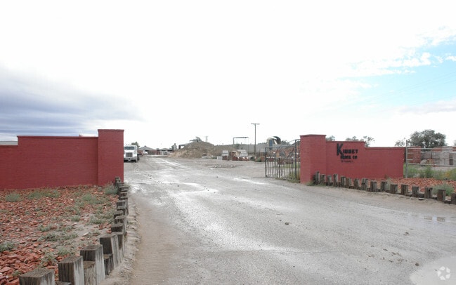
100 Prosperity Ave Se
1-013-052-456474-1-02-22
New Mexico Brick Co Inc
Manufacturinglight
LT A-1-A PLAT OF LTS A1A, A3A & A4A LANDS OF NEW MEXICO BRIC K CO INC CONT 11.6217 AC M/L
AH
Bernalillo
35001C0343H
New Mexico
2024
11.62 AC
2025
South Valley
004001
Albuquerque
6,000 SF
Albuquerque, NM
DEMOGRAPHICS near 100 Prosperity Ave Se
1 Mile
3 Mile
5 Mile
2024 Total Population
2,618
21,625
99,457
2029 Population
2,570
21,406
98,908
Pop Growth 2024-2029
(1.83%)
(1.01%)
(0.55%)
Average Age
38
40
38
2024 Total Households
825
7,395
36,269
HH Growth 2024-2029
(2.06%)
(1.12%)
(0.50%)
Median Household Inc
$41,078
$47,302
$46,393
Avg Household Size
3.00
2.80
2.60
2024 Avg HH Vehicles
2.00
2.00
2.00
Median Home Value
$153,333
$199,942
$185,396
Median Year Built
1975
1970
1976
Nearby Places
- Restaurants
- Banks
- Shops
- Fitness
- Groceries
PUBLIC TRANSPORTATION
COMMUTER RAIL
Bernalillo County-International Sunport (NMRX - Rio Metro Regional Transit District, Rail Runner Express - Rio Metro Regional Transit District)
DRIVE
WALK
Distance
Bernalillo County-International Sunport (NMRX - Rio Metro Regional Transit District, Rail Runner Express - Rio Metro Regional Transit District)
4 min
1.8 mi
Isleta Pueblo (NMRX - Rio Metro Regional Transit District, Rail Runner Express - Rio Metro Regional Transit District)
DRIVE
WALK
Distance
Isleta Pueblo (NMRX - Rio Metro Regional Transit District, Rail Runner Express - Rio Metro Regional Transit District)
10 min
5.9 mi
AIRPORT
Albuquerque International Sunport
DRIVE
WALK
Distance
Albuquerque International Sunport
22 min
7.4 mi
Freight Ports
Tulsa Port Of Catoosa
DRIVE
WALK
Distance
Tulsa Port Of Catoosa
698 min
669.4 mi
Nearby Properties
Address
Land Use
TOTAL SIZE
Lot Size
Zoning
Address
Land Use
TOTAL SIZE
Lot Size
Zoning
144,637 SF
28.44 AC
Address
Land Use
TOTAL SIZE
Lot Size
Zoning
167,640 SF
11.74 AC
Address
Land Use
TOTAL SIZE
Lot Size
Zoning
6,631 SF
21.01 AC
Address
Land Use
TOTAL SIZE
Lot Size
Zoning
1,232 SF
629.67 AC
Address
Land Use
TOTAL SIZE
Lot Size
Zoning
134,349 SF
38.81 AC
Address
Land Use
TOTAL SIZE
Lot Size
Zoning
149,648 SF
8.70 AC
Address
Land Use
TOTAL SIZE
Lot Size
Zoning
211,480 SF
25.31 AC
Address
Land Use
TOTAL SIZE
Lot Size
Zoning
237,300 SF
24.42 AC
Address
Land Use
TOTAL SIZE
Lot Size
Zoning
88,456 SF
27.26 AC
Address
Land Use
TOTAL SIZE
Lot Size
Zoning
193,336 SF
61.89 AC
Address
Land Use
TOTAL SIZE
Lot Size
Zoning
131,873 SF
34.28 AC
Address
Land Use
TOTAL SIZE
Lot Size
Zoning
84,351 SF
2.30 AC
Address
Land Use
TOTAL SIZE
Lot Size
Zoning
30,552 SF
10.48 AC
Address
Land Use
TOTAL SIZE
Lot Size
Zoning
144,100 SF
6.52 AC
Address
Land Use
TOTAL SIZE
Lot Size
Zoning
88,256 SF
6.70 AC
Address
Land Use
TOTAL SIZE
Lot Size
Zoning
44,035 SF
12.05 AC
Address
Land Use
TOTAL SIZE
Lot Size
Zoning
13,403 SF
17.94 AC
Address
Land Use
TOTAL SIZE
Lot Size
Zoning
46,173 SF
8.29 AC
Address
Land Use
TOTAL SIZE
Lot Size
Zoning
10,370 SF
4.86 AC
Address
Land Use
TOTAL SIZE
Lot Size
Zoning
74,160 SF
2.97 AC
Address
Land Use
TOTAL SIZE
Lot Size
Zoning
228.66 AC
Address
Land Use
TOTAL SIZE
Lot Size
Zoning
192.50 AC
Address
Land Use
TOTAL SIZE
Lot Size
Zoning
74,528 SF
2.40 AC
Address
Land Use
TOTAL SIZE
Lot Size
Zoning
Address
Land Use
TOTAL SIZE
Lot Size
Zoning
78,019 SF
2.12 AC
Address
Land Use
TOTAL SIZE
Lot Size
Zoning
82,440 SF
9.60 AC
Address
Land Use
TOTAL SIZE
Lot Size
Zoning
85,260 SF
3.93 AC
Address
Land Use
TOTAL SIZE
Lot Size
Zoning
76,160 SF
7.40 AC
Address
Land Use
TOTAL SIZE
Lot Size
Zoning
76,094 SF
7 AC
Address
Land Use
TOTAL SIZE
Lot Size
Zoning
48,000 SF
16.34 AC
The World's #1 Commercial Real Estate Marketplace
Connect with us
© 2025 CoStar Group
The information above has been obtained from sources believed reliable. While we do not doubt its accuracy we have not verified it and make no guarantee, warranty or representation about it. It is your responsibility to independently confirm its accuracy and completeness. Any projections, opinions, assumptions, or estimates used are for example only and do not represent the current or future performance of the property. The value of this transaction to you depends on tax and other factors which should be evaluated by your tax, financial, and legal advisors. You and your advisors should conduct a careful, independent investigation of the property to determine to your satisfaction the suitability of the property for your needs.