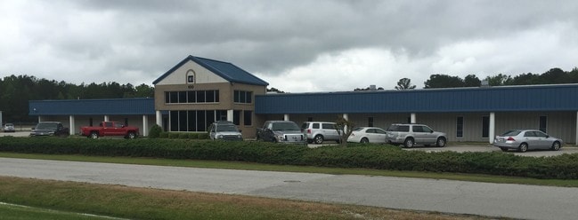
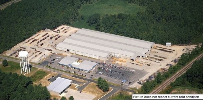
Property Record
100 Red Iron Rd, Rocky Mount, NC 27804


NEARBY LISTINGS FOR SALE OR LEASE
-
-
View all Rocky Mount listings for lease on LoopNet.com
Property Detail
100 Red Iron Rd
3863-19-50-5873
301 1, 19.48 AC, ROBERTSON CECO AC, 1C, ROBERTSON CECO
Multipleuses
Nash
X
North Carolina
3720386300J
19.48 AC
2025
Rocky Mount/Wilson
2025
Other Market Areas
010700
Rocky Mount, NC
228,800 SF
DEMOGRAPHICS near 100 Red Iron Rd
1 Mile
3 Mile
5 Mile
2024 Total Population
380
5,055
15,318
2029 Population
397
5,135
15,610
Pop Growth 2024-2029
+ 4.47%
+ 1.58%
+ 1.91%
Average Age
46
40
41
2024 Total Households
169
2,047
6,693
HH Growth 2024-2029
+ 4.14%
+ 1.76%
+ 1.96%
Median Household Inc
$67,500
$56,758
$57,582
Avg Household Size
2.20
2.30
2.20
2024 Avg HH Vehicles
2.00
2.00
2.00
Median Home Value
$235,714
$118,397
$141,672
Median Year Built
1992
1979
1985
Nearby Places
Map Layers
Map Styles
 Street
 Aerial
- Restaurants
- Banks
- Shops
- Fitness
- Groceries
PUBLIC TRANSPORTATION
COMMUTER RAIL
Rocky Mount (Carolinian - Amtrak, Palmetto - Amtrak, Silver Meteor - Amtrak, Silver Star - Amtrak)
DRIVE
WALK
Distance
Rocky Mount (Carolinian - Amtrak, Palmetto - Amtrak, Silver Meteor - Amtrak, Silver Star - Amtrak)
11 min
6.8 mi
Freight Ports
Virginia Port Authority - Portsmouth
DRIVE
WALK
Distance
Virginia Port Authority - Portsmouth
153 min
130.6 mi
SALE & LEASE HISTORY
LISTING DATE
SALE/LEASE

Sep 24, 2016
For Sale
Jul 10, 2017
For Sale
Jul 10, 2017
For Sale
Jan 17, 2018
For Lease
Nearby Properties
Address
Land Use
TOTAL SIZE
Lot Size
Zoning
Address
Land Use
TOTAL SIZE
Lot Size
Zoning
23,636 SF
111.07 AC
Address
Land Use
TOTAL SIZE
Lot Size
Zoning
3,072 SF
181.13 AC
Address
Land Use
TOTAL SIZE
Lot Size
Zoning
41,620 SF
32.43 AC
R30
Address
Land Use
TOTAL SIZE
Lot Size
Zoning
8,020 SF
13.81 AC
R6
Address
Land Use
TOTAL SIZE
Lot Size
Zoning
120,560 SF
27.50 AC
I2
Address
Land Use
TOTAL SIZE
Lot Size
Zoning
96,000 SF
62.07 AC
I2CU
Address
Land Use
TOTAL SIZE
Lot Size
Zoning
12,660 SF
95.06 AC
Address
Land Use
TOTAL SIZE
Lot Size
Zoning
310,108 SF
33.68 AC
I2
Address
Land Use
TOTAL SIZE
Lot Size
Zoning
204,794 SF
14.85 AC
I2
Address
Land Use
TOTAL SIZE
Lot Size
Zoning
25,432 SF
78.78 AC
Address
Land Use
TOTAL SIZE
Lot Size
Zoning
Address
Land Use
TOTAL SIZE
Lot Size
Zoning
21,962 SF
3.15 AC
I
Address
Land Use
TOTAL SIZE
Lot Size
Zoning
114,765 SF
47 AC
Address
Land Use
TOTAL SIZE
Lot Size
Zoning
51,339 SF
6.89 AC
Address
Land Use
TOTAL SIZE
Lot Size
Zoning
71.54 AC
Address
Land Use
TOTAL SIZE
Lot Size
Zoning
181,200 SF
10 AC
I
Address
Land Use
TOTAL SIZE
Lot Size
Zoning
105,758 SF
33.06 AC
Address
Land Use
TOTAL SIZE
Lot Size
Zoning
9,240 SF
8.58 AC
PUDCU
Address
Land Use
TOTAL SIZE
Lot Size
Zoning
66,320 SF
31.85 AC
I2
Address
Land Use
TOTAL SIZE
Lot Size
Zoning
9,000 SF
28.48 AC
Address
Land Use
TOTAL SIZE
Lot Size
Zoning
157,920 SF
14.27 AC
I
Address
Land Use
TOTAL SIZE
Lot Size
Zoning
32,394 SF
8.63 AC
Address
Land Use
TOTAL SIZE
Lot Size
Zoning
36,736 SF
13.37 AC
B5
Address
Land Use
TOTAL SIZE
Lot Size
Zoning
144.46 AC
Address
Land Use
TOTAL SIZE
Lot Size
Zoning
10,908 SF
1.91 AC
PDRCU
Address
Land Use
TOTAL SIZE
Lot Size
Zoning
194,728 SF
15.24 AC
Address
Land Use
TOTAL SIZE
Lot Size
Zoning
41,528 SF
11.54 AC
B2
Address
Land Use
TOTAL SIZE
Lot Size
Zoning
85,120 SF
12.68 AC
MI
Address
Land Use
TOTAL SIZE
Lot Size
Zoning
55,416 SF
47.24 AC
I2
The World's #1 Commercial Real Estate Marketplace
Connect with us
© 2025 CoStar Group
The information above has been obtained from sources believed reliable. While we do not doubt its accuracy we have not verified it and make no guarantee, warranty or representation about it. It is your responsibility to independently confirm its accuracy and completeness. Any projections, opinions, assumptions, or estimates used are for example only and do not represent the current or future performance of the property. The value of this transaction to you depends on tax and other factors which should be evaluated by your tax, financial, and legal advisors. You and your advisors should conduct a careful, independent investigation of the property to determine to your satisfaction the suitability of the property for your needs.