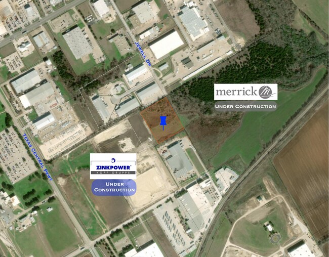
Property Record
100 Ritchie Rd, Woodway, TX 76712

Property Detail
100 Ritchie Rd
Waco, TX
FARRAR ADDITION LOT 1 BLOCK 1 ACRES 3.626
36-224515-000100-0
MCLENNAN
Commercialnec
Texas
B and X Area of moderate flood hazard, usually the area between the limits of the 100-year and 500-year floods.
1
2024
3.63 AC
2025
Waco
003712
Other Market Areas
6,500 SF
NEARBY LISTINGS FOR SALE OR LEASE
DEMOGRAPHICS near 100 Ritchie Rd
1 mile
3 mile
5 mile
2025 Total Population
6,384
29,710
52,581
2030 Population
6,660
30,674
54,198
Pop Growth 2025-2030
+ 4.32%
+ 3.24%
+ 3.08%
Average Age
39
40
40
2025 Total Households
2,348
11,050
19,770
HH Growth 2025-2030
+ 4.30%
+ 3.25%
+ 3.10%
Median Household Inc
$105,174
$92,642
$92,747
Avg Household Size
2.70
2.60
2.60
2025 Avg HH Vehicles
2.00
2.00
2.00
Median Home Value
$320,351
$303,817
$318,881
Median Year Built
2000
1995
1993
Nearby Places
Map Layers
Map Styles
 Street
 Aerial
Layers
 Traffic
 Biking
Places
Listings with unknown addresses are not visible on the map
- Restaurants
- Banks
- Shops
- Fitness
- Groceries
PUBLIC TRANSPORTATION
AIRPORT
Waco Regional
Drive
Walk
Distance
Waco Regional
32 min
16.2 mi
Freight Ports
Port of Houston
Drive
Walk
Distance
Port of Houston
225 min
193.6 mi
SALE & LEASE HISTORY
LISTING DATE
SALE/LEASE

Dec 18, 2020
For Lease
Nearby Properties
Address
Land Use
TOTAL SIZE
Lot Size
Zoning
Address
Land Use
TOTAL SIZE
Lot Size
Zoning
Address
Land Use
TOTAL SIZE
Lot Size
Zoning
108,521 SF
70.78 AC
Address
Land Use
TOTAL SIZE
Lot Size
Zoning
752,540 SF
96.04 AC
M-2
Address
Land Use
TOTAL SIZE
Lot Size
Zoning
279,135 SF
13 AC
Address
Land Use
TOTAL SIZE
Lot Size
Zoning
Address
Land Use
TOTAL SIZE
Lot Size
Zoning
Address
Land Use
TOTAL SIZE
Lot Size
Zoning
222,388 SF
10.68 AC
R-3C
Address
Land Use
TOTAL SIZE
Lot Size
Zoning
221,876 SF
12.26 AC
C-2
Address
Land Use
TOTAL SIZE
Lot Size
Zoning
108,969 SF
24.73 AC
R-1
Address
Land Use
TOTAL SIZE
Lot Size
Zoning
219,544 SF
23.11 AC
Address
Land Use
TOTAL SIZE
Lot Size
Zoning
99,179 SF
54.16 AC
R1
Address
Land Use
TOTAL SIZE
Lot Size
Zoning
Address
Land Use
TOTAL SIZE
Lot Size
Zoning
87,492 SF
29.99 AC
R1
Address
Land Use
TOTAL SIZE
Lot Size
Zoning
174,456 SF
9.04 AC
R3C
Address
Land Use
TOTAL SIZE
Lot Size
Zoning
72,920 SF
11 AC
C-3
Address
Land Use
TOTAL SIZE
Lot Size
Zoning
150,212 SF
16.79 AC
Address
Land Use
TOTAL SIZE
Lot Size
Zoning
162,693 SF
17.63 AC
Address
Land Use
TOTAL SIZE
Lot Size
Zoning
82.98 AC
M-2
Address
Land Use
TOTAL SIZE
Lot Size
Zoning
65,016 SF
5.08 AC
C-2
Address
Land Use
TOTAL SIZE
Lot Size
Zoning
114,575 SF
4.20 AC
Address
Land Use
TOTAL SIZE
Lot Size
Zoning
156,531 SF
7.51 AC
R-4
Address
Land Use
TOTAL SIZE
Lot Size
Zoning
64,455 SF
8.56 AC
Address
Land Use
TOTAL SIZE
Lot Size
Zoning
8.39 AC
Address
Land Use
TOTAL SIZE
Lot Size
Zoning
57,606 SF
19.63 AC
R1
Address
Land Use
TOTAL SIZE
Lot Size
Zoning
Address
Land Use
TOTAL SIZE
Lot Size
Zoning
60,876 SF
39.29 AC
R1
Address
Land Use
TOTAL SIZE
Lot Size
Zoning
28,286 SF
16.23 AC
R
Address
Land Use
TOTAL SIZE
Lot Size
Zoning
42,271 SF
18.65 AC
Address
Land Use
TOTAL SIZE
Lot Size
Zoning
136,445 SF
8.68 AC
R-4
Address
Land Use
TOTAL SIZE
Lot Size
Zoning
77.94 AC
The World's #1 Commercial Real Estate Marketplace
Connect with us
© 2026 CoStar Group
The information above has been obtained from sources believed reliable. While we do not doubt its accuracy we have not verified it and make no guarantee, warranty or representation about it. It is your responsibility to independently confirm its accuracy and completeness. Any projections, opinions, assumptions, or estimates used are for example only and do not represent the current or future performance of the property. The value of this transaction to you depends on tax and other factors which should be evaluated by your tax, financial, and legal advisors. You and your advisors should conduct a careful, independent investigation of the property to determine to your satisfaction the suitability of the property for your needs.