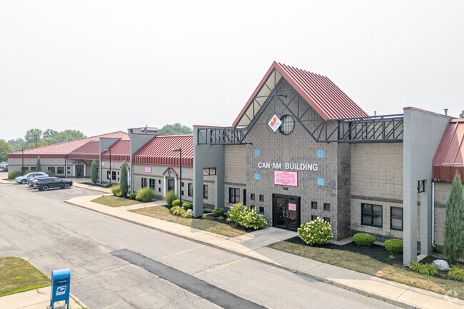
Property Record
100 River Rock Dr, Buffalo, NY 14207


Current Lease Availabilities
NEARBY LISTINGS FOR SALE OR LEASE
Property Detail
100 River Rock Dr
Buffalo-Cheektowaga-Niagara Falls, NY
Alta Nspa Land Title Survey River Rock D
140200-077-740-0005-009-110
S COR RANO 234.79 S/L; IRR DEPTH
Manufacturinglight
Erie
X
New York
36029C0184J
9.110
2025
3.26 AC
2024
Greater Buffalo
005700
Buffalo/Niagara Falls
50,000 SF
DEMOGRAPHICS near 100 River Rock Dr
1 Mile
3 Mile
5 Mile
2024 Total Population
20,211
119,504
284,231
2029 Population
19,406
116,439
278,975
Pop Growth 2024-2029
(3.98%)
(2.56%)
(1.85%)
Average Age
35
38
39
2024 Total Households
7,869
53,202
124,692
HH Growth 2024-2029
(4.00%)
(2.58%)
(1.82%)
Median Household Inc
$30,755
$54,509
$49,927
Avg Household Size
2.40
2.10
2.20
2024 Avg HH Vehicles
1.00
1.00
1.00
Median Home Value
$77,293
$192,053
$168,535
Median Year Built
1946
1946
1948
Nearby Places
Map Layers
Map Styles
 Street
 Aerial
- Restaurants
- Banks
- Shops
- Fitness
- Groceries
PUBLIC TRANSPORTATION
COMMUTER RAIL
Buffalo (Exchange) (Empire Service - Amtrak, Maple Leaf - Amtrak, Toronto - New York - Amtrak)
DRIVE
WALK
Distance
Buffalo (Exchange) (Empire Service - Amtrak, Maple Leaf - Amtrak, Toronto - New York - Amtrak)
11 min
6.5 mi
AIRPORT
Buffalo Niagara International
DRIVE
WALK
Distance
Buffalo Niagara International
25 min
12.3 mi
Niagara Falls International
DRIVE
WALK
Distance
Niagara Falls International
24 min
15.8 mi
Freight Ports
Port of Toledo
DRIVE
WALK
Distance
Port of Toledo
367 min
309.0 mi
Nearby Properties
Address
Land Use
TOTAL SIZE
Lot Size
Zoning
Address
Land Use
TOTAL SIZE
Lot Size
Zoning
6,120 SF
87.10 AC
D-IL
Address
Land Use
TOTAL SIZE
Lot Size
Zoning
8,317 SF
39.03 AC
SPLIT ZONE
Address
Land Use
TOTAL SIZE
Lot Size
Zoning
80,927 SF
28.20 AC
WID
Address
Land Use
TOTAL SIZE
Lot Size
Zoning
121,015 SF
92.60 AC
D-E
Address
Land Use
TOTAL SIZE
Lot Size
Zoning
561,196 SF
16 AC
D-M
Address
Land Use
TOTAL SIZE
Lot Size
Zoning
21,200 SF
20.94 AC
D-IL
Address
Land Use
TOTAL SIZE
Lot Size
Zoning
36,325 SF
12.50 AC
D-E
Address
Land Use
TOTAL SIZE
Lot Size
Zoning
239,735 SF
17.73 AC
TND
Address
Land Use
TOTAL SIZE
Lot Size
Zoning
12,641 SF
0.56 AC
N-2C
Address
Land Use
TOTAL SIZE
Lot Size
Zoning
94,680 SF
175.90 AC
D-OG
Address
Land Use
TOTAL SIZE
Lot Size
Zoning
59,670 SF
911.28 AC
OS
Address
Land Use
TOTAL SIZE
Lot Size
Zoning
119,851 SF
1.35 AC
N-2R
Address
Land Use
TOTAL SIZE
Lot Size
Zoning
650,000 SF
42.15 AC
G-1
Address
Land Use
TOTAL SIZE
Lot Size
Zoning
61,327 SF
175 AC
D-OG
Address
Land Use
TOTAL SIZE
Lot Size
Zoning
67,666 SF
17.43 AC
G-1
Address
Land Use
TOTAL SIZE
Lot Size
Zoning
3.20 AC
G-1
Address
Land Use
TOTAL SIZE
Lot Size
Zoning
679,645 SF
3.20 AC
N-1S
Address
Land Use
TOTAL SIZE
Lot Size
Zoning
73,128 SF
3.11 AC
N-2R
Address
Land Use
TOTAL SIZE
Lot Size
Zoning
11,808 SF
11.93 AC
N-3R
Address
Land Use
TOTAL SIZE
Lot Size
Zoning
192,811 SF
3.30 AC
D-E
Address
Land Use
TOTAL SIZE
Lot Size
Zoning
120,954 SF
9.74 AC
D-S
Address
Land Use
TOTAL SIZE
Lot Size
Zoning
16 AC
G-1
Address
Land Use
TOTAL SIZE
Lot Size
Zoning
87,659 SF
11.40 AC
D-E
Address
Land Use
TOTAL SIZE
Lot Size
Zoning
118,080 SF
2.77 AC
D-R
Address
Land Use
TOTAL SIZE
Lot Size
Zoning
80,369 SF
1.16 AC
N-2R
Address
Land Use
TOTAL SIZE
Lot Size
Zoning
41,752 SF
8.95 AC
SPLIT ZONE
Address
Land Use
TOTAL SIZE
Lot Size
Zoning
151,641 SF
1.53 AC
N-1S
Address
Land Use
TOTAL SIZE
Lot Size
Zoning
43,219 SF
4.64 AC
D-E
Address
Land Use
TOTAL SIZE
Lot Size
Zoning
138,000 SF
7.30 AC
P-S
Address
Land Use
TOTAL SIZE
Lot Size
Zoning
55,419 SF
14.78 AC
SPLIT ZONE
The World's #1 Commercial Real Estate Marketplace
Connect with us
© 2026 CoStar Group
The information above has been obtained from sources believed reliable. While we do not doubt its accuracy we have not verified it and make no guarantee, warranty or representation about it. It is your responsibility to independently confirm its accuracy and completeness. Any projections, opinions, assumptions, or estimates used are for example only and do not represent the current or future performance of the property. The value of this transaction to you depends on tax and other factors which should be evaluated by your tax, financial, and legal advisors. You and your advisors should conduct a careful, independent investigation of the property to determine to your satisfaction the suitability of the property for your needs.