Property Record
100 S 1St St, Bennett, CO 80102
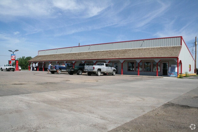

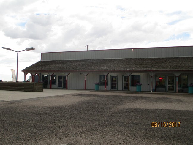

Property Detail
100 S 1St St
Denver-Aurora-Centennial, CO
SUB:MITCHEMS SECOND ADDITION TOWN OF BENNETT BLK:5 DESC: LOTS 17 THRU 24 TOG WITH VAC ALLEY AND TOG WITH W 10 FT OF 16 FT ALLEY EXC HIWAY
1815-27-3-21-006
Arapahoe
Storebuilding
Colorado
B and X Area of moderate flood hazard, usually the area between the limits of the 100-year and 500-year floods.
17-24
2024
0.64 AC
2025
Northeast
008401
Denver
4,896 SF
NEARBY LISTINGS FOR SALE OR LEASE
-
-
View all Bennett listings for sale on LoopNet.com
DEMOGRAPHICS near 100 S 1St St
1 mile
3 mile
5 mile
2025 Total Population
3,741
4,160
6,021
2030 Population
4,142
4,583
6,502
Pop Growth 2025-2030
+ 10.72%
+ 10.17%
+ 7.99%
Average Age
37
37
38
2025 Total Households
1,272
1,416
2,057
HH Growth 2025-2030
+ 10.93%
+ 10.38%
+ 8.17%
Median Household Inc
$106,115
$107,645
$109,653
Avg Household Size
2.90
2.90
2.90
2025 Avg HH Vehicles
2.00
3.00
3.00
Median Home Value
$424,672
$432,985
$467,922
Median Year Built
1997
1998
1997
Nearby Places
Map Layers
Map Styles
 Street
 Aerial
Transit
 Traffic
 Biking
Places
Listings with unknown addresses are not visible on the map
- Restaurants
- Banks
- Shops
- Fitness
- Groceries
PUBLIC TRANSPORTATION
AIRPORT
Denver International
Drive
Walk
Distance
Denver International
41 min
34.1 mi
Freight Ports
Tulsa Port Of Catoosa
Drive
Walk
Distance
Tulsa Port Of Catoosa
699 min
679.1 mi
SALE & LEASE HISTORY
LISTING DATE
SALE/LEASE

Oct 28, 2020
For Sale
Aug 31, 2017
For Sale
Nearby Properties
Address
Land Use
TOTAL SIZE
Lot Size
Zoning
Address
Land Use
TOTAL SIZE
Lot Size
Zoning
66,260 SF
6.45 AC
Address
Land Use
TOTAL SIZE
Lot Size
Zoning
28,500 SF
4.99 AC
Address
Land Use
TOTAL SIZE
Lot Size
Zoning
17,942 SF
2.43 AC
Address
Land Use
TOTAL SIZE
Lot Size
Zoning
7,140 SF
2.32 AC
Address
Land Use
TOTAL SIZE
Lot Size
Zoning
45,147 SF
1.50 AC
Address
Land Use
TOTAL SIZE
Lot Size
Zoning
9,567 SF
1.35 AC
Address
Land Use
TOTAL SIZE
Lot Size
Zoning
15,822 SF
7.02 AC
Address
Land Use
TOTAL SIZE
Lot Size
Zoning
23,486 SF
3.72 AC
Address
Land Use
TOTAL SIZE
Lot Size
Zoning
13,154 SF
4.31 AC
Address
Land Use
TOTAL SIZE
Lot Size
Zoning
5,856 SF
5.28 AC
Address
Land Use
TOTAL SIZE
Lot Size
Zoning
88 SF
0.74 AC
Address
Land Use
TOTAL SIZE
Lot Size
Zoning
5,711 SF
3.11 AC
Address
Land Use
TOTAL SIZE
Lot Size
Zoning
4,484 SF
0.49 AC
Address
Land Use
TOTAL SIZE
Lot Size
Zoning
8,400 SF
1.56 AC
Address
Land Use
TOTAL SIZE
Lot Size
Zoning
2.52 AC
Address
Land Use
TOTAL SIZE
Lot Size
Zoning
1,222 SF
0.91 AC
Address
Land Use
TOTAL SIZE
Lot Size
Zoning
2,516 SF
0.72 AC
Address
Land Use
TOTAL SIZE
Lot Size
Zoning
0.80 AC
Address
Land Use
TOTAL SIZE
Lot Size
Zoning
1.81 AC
Address
Land Use
TOTAL SIZE
Lot Size
Zoning
4,504 SF
4.72 AC
Address
Land Use
TOTAL SIZE
Lot Size
Zoning
6,000 SF
1.85 AC
AA1
Address
Land Use
TOTAL SIZE
Lot Size
Zoning
6,372 SF
35.03 AC
AA1
Address
Land Use
TOTAL SIZE
Lot Size
Zoning
82.24 AC
AA1
Address
Land Use
TOTAL SIZE
Lot Size
Zoning
1.46 AC
Address
Land Use
TOTAL SIZE
Lot Size
Zoning
119.40 AC
AA1
Address
Land Use
TOTAL SIZE
Lot Size
Zoning
4,942 SF
322.96 AC
AA1
Address
Land Use
TOTAL SIZE
Lot Size
Zoning
67.57 AC
AA1
Address
Land Use
TOTAL SIZE
Lot Size
Zoning
0.87 AC
Address
Land Use
TOTAL SIZE
Lot Size
Zoning
624 SF
0.25 AC
The World's #1 Commercial Real Estate Marketplace
Connect with us
© 2026 CoStar Group
The information above has been obtained from sources believed reliable. While we do not doubt its accuracy we have not verified it and make no guarantee, warranty or representation about it. It is your responsibility to independently confirm its accuracy and completeness. Any projections, opinions, assumptions, or estimates used are for example only and do not represent the current or future performance of the property. The value of this transaction to you depends on tax and other factors which should be evaluated by your tax, financial, and legal advisors. You and your advisors should conduct a careful, independent investigation of the property to determine to your satisfaction the suitability of the property for your needs.