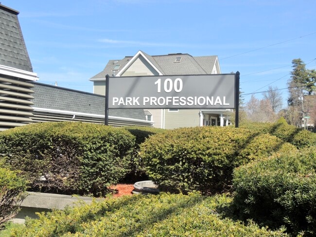
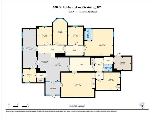
Property Record
100 S Highland Ave, Ossining, NY 10562
NEARBY LISTINGS FOR SALE OR LEASE
Property Detail
100 S Highland Ave
Westchester/So Connecticut
Westchester
New York-Jersey City-White Plains, NY-NJ
New York
554203-097-011-00000-000-0002-057-0008
0.01 AC
Condominium
Northwest
DEMOGRAPHICS near 100 S Highland Ave
1 Mile
3 Mile
5 Mile
2024 Total Population
17,027
39,586
98,840
2029 Population
16,405
38,533
96,934
Pop Growth 2024-2029
(3.65%)
(2.66%)
(1.93%)
Average Age
39
42
42
2024 Total Households
6,186
14,243
34,308
HH Growth 2024-2029
(3.64%)
(2.85%)
(2.10%)
Median Household Inc
$85,483
$115,496
$134,876
Avg Household Size
2.70
2.70
2.70
2024 Avg HH Vehicles
2.00
2.00
2.00
Median Home Value
$387,859
$512,910
$646,264
Median Year Built
1960
1963
1961
Nearby Places
Map Layers
Map Styles
 Street
 Aerial
- Restaurants
- Banks
- Shops
- Fitness
- Groceries
PUBLIC TRANSPORTATION
COMMUTER RAIL
Ossining Station (Hudson Line - Metro-North Commuter Railroad Company (Metro-North))
DRIVE
WALK
Distance
Ossining Station (Hudson Line - Metro-North Commuter Railroad Company (Metro-North))
3 min
18 min
1.0 mi
Scarborough Station (Hudson Line - Metro-North Commuter Railroad Company (Metro-North))
DRIVE
WALK
Distance
Scarborough Station (Hudson Line - Metro-North Commuter Railroad Company (Metro-North))
4 min
1.4 mi
AIRPORT
Westchester County
DRIVE
WALK
Distance
Westchester County
30 min
17.3 mi
LaGuardia
DRIVE
WALK
Distance
LaGuardia
51 min
32.9 mi
New York Stewart International
DRIVE
WALK
Distance
New York Stewart International
59 min
34.7 mi
Freight Ports
NY - Red Hook Container Terminal
DRIVE
WALK
Distance
NY - Red Hook Container Terminal
63 min
41.1 mi
SALE & LEASE HISTORY
LISTING DATE
SALE/LEASE

Oct 31, 2019
For Lease
Oct 07, 2022
For Lease
Nov 24, 2021
For Lease
May 06, 2024
For Lease
May 03, 2024
For Sale
Mar 03, 2020
For Lease
Jul 06, 2021
For Lease
Jan 25, 2024
For Lease
Jan 25, 2019
For Lease
Jan 08, 2020
For Lease
Nearby Properties
Address
Land Use
TOTAL SIZE
Lot Size
Zoning
Address
Land Use
TOTAL SIZE
Lot Size
Zoning
Address
Land Use
TOTAL SIZE
Lot Size
Zoning
Address
Land Use
TOTAL SIZE
Lot Size
Zoning
Address
Land Use
TOTAL SIZE
Lot Size
Zoning
15.18 AC
Address
Land Use
TOTAL SIZE
Lot Size
Zoning
2.67 AC
Address
Land Use
TOTAL SIZE
Lot Size
Zoning
13 AC
Address
Land Use
TOTAL SIZE
Lot Size
Zoning
16.69 AC
Address
Land Use
TOTAL SIZE
Lot Size
Zoning
20.80 AC
Address
Land Use
TOTAL SIZE
Lot Size
Zoning
26.16 AC
Address
Land Use
TOTAL SIZE
Lot Size
Zoning
14.75 AC
Address
Land Use
TOTAL SIZE
Lot Size
Zoning
32.20 AC
Address
Land Use
TOTAL SIZE
Lot Size
Zoning
Address
Land Use
TOTAL SIZE
Lot Size
Zoning
56.91 AC
Address
Land Use
TOTAL SIZE
Lot Size
Zoning
11.66 AC
Address
Land Use
TOTAL SIZE
Lot Size
Zoning
Address
Land Use
TOTAL SIZE
Lot Size
Zoning
10.33 AC
Address
Land Use
TOTAL SIZE
Lot Size
Zoning
Address
Land Use
TOTAL SIZE
Lot Size
Zoning
0.50 AC
Address
Land Use
TOTAL SIZE
Lot Size
Zoning
5.88 AC
Address
Land Use
TOTAL SIZE
Lot Size
Zoning
19.20 AC
Address
Land Use
TOTAL SIZE
Lot Size
Zoning
7.10 AC
Address
Land Use
TOTAL SIZE
Lot Size
Zoning
1.01 AC
Address
Land Use
TOTAL SIZE
Lot Size
Zoning
21 AC
Address
Land Use
TOTAL SIZE
Lot Size
Zoning
11.11 AC
Address
Land Use
TOTAL SIZE
Lot Size
Zoning
5.54 AC
Address
Land Use
TOTAL SIZE
Lot Size
Zoning
1.87 AC
Address
Land Use
TOTAL SIZE
Lot Size
Zoning
Address
Land Use
TOTAL SIZE
Lot Size
Zoning
7.81 AC
Address
Land Use
TOTAL SIZE
Lot Size
Zoning
Address
Land Use
TOTAL SIZE
Lot Size
Zoning
16.70 AC
The World's #1 Commercial Real Estate Marketplace
Connect with us
© 2025 CoStar Group
The information above has been obtained from sources believed reliable. While we do not doubt its accuracy we have not verified it and make no guarantee, warranty or representation about it. It is your responsibility to independently confirm its accuracy and completeness. Any projections, opinions, assumptions, or estimates used are for example only and do not represent the current or future performance of the property. The value of this transaction to you depends on tax and other factors which should be evaluated by your tax, financial, and legal advisors. You and your advisors should conduct a careful, independent investigation of the property to determine to your satisfaction the suitability of the property for your needs.