Property Record
100 S Holiday Rd, Port Orange, FL 32127

NEARBY LISTINGS FOR SALE OR LEASE
-
-
View all Port Orange listings for sale on LoopNet.com
Property Detail
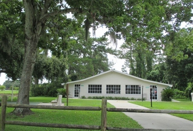
100 S Holiday Rd
Deltona-Daytona Beach-Ormond Beach, FL
Acreage
6315-00-00-0050
15 16 33 SW 1/4 OF NE 1/4 S OF NOVA RD EXC NEW WATER RETENTION AREA & SE 1/4 OF NW 1/4 S OF NOVA RD & E OF FEC RR & NE 1/4 OF SW 1/4 E OF FEC RR & GOVT LOTS 1 & 2 PER OR 4322 PG 4701 PER OR 7211 PG 4947
Recreationalentertainmentgeneral
Volusia
AE
Florida
12127C0526J
1-2
2025
0.14 AC
2025
Outer Port Orange
082510
Deltona/Daytona Beach
7,375 SF
DEMOGRAPHICS near 100 S Holiday Rd
1 Mile
3 Mile
5 Mile
2024 Total Population
9,190
44,248
104,414
2029 Population
10,144
49,304
116,340
Pop Growth 2024-2029
+ 10.38%
+ 11.43%
+ 11.42%
Average Age
47
47
48
2024 Total Households
4,153
20,005
48,088
HH Growth 2024-2029
+ 10.57%
+ 11.84%
+ 11.79%
Median Household Inc
$43,179
$56,771
$57,736
Avg Household Size
2.20
2.10
2.10
2024 Avg HH Vehicles
2.00
2.00
2.00
Median Home Value
$152,338
$251,605
$255,123
Median Year Built
1977
1982
1986
Nearby Places
Map Layers
Map Styles
 Street
 Aerial
- Restaurants
- Banks
- Shops
- Fitness
- Groceries
PUBLIC TRANSPORTATION
AIRPORT
Daytona Beach International
DRIVE
WALK
Distance
Daytona Beach International
15 min
8.5 mi
Orlando Sanford International
DRIVE
WALK
Distance
Orlando Sanford International
56 min
39.2 mi
Freight Ports
Port Canaveral
DRIVE
WALK
Distance
Port Canaveral
80 min
67.7 mi
Nearby Properties
Address
Land Use
TOTAL SIZE
Lot Size
Zoning
Address
Land Use
TOTAL SIZE
Lot Size
Zoning
448,867 SF
5.54 AC
Address
Land Use
TOTAL SIZE
Lot Size
Zoning
408,078 SF
50.07 AC
Address
Land Use
TOTAL SIZE
Lot Size
Zoning
325,744 SF
12.23 AC
Address
Land Use
TOTAL SIZE
Lot Size
Zoning
150,197 SF
16.07 AC
Address
Land Use
TOTAL SIZE
Lot Size
Zoning
94,338 SF
7.39 AC
Address
Land Use
TOTAL SIZE
Lot Size
Zoning
60,449 SF
7.14 AC
16PCD
Address
Land Use
TOTAL SIZE
Lot Size
Zoning
184,242 SF
14.43 AC
Address
Land Use
TOTAL SIZE
Lot Size
Zoning
9,952 SF
9.30 AC
16RMH
Address
Land Use
TOTAL SIZE
Lot Size
Zoning
269,160 SF
72.17 AC
16A
Address
Land Use
TOTAL SIZE
Lot Size
Zoning
156,994 SF
47.82 AC
16A
Address
Land Use
TOTAL SIZE
Lot Size
Zoning
155,590 SF
11.08 AC
16R3H
Address
Land Use
TOTAL SIZE
Lot Size
Zoning
9,061 SF
0.23 AC
16RMH
Address
Land Use
TOTAL SIZE
Lot Size
Zoning
148,848 SF
9.99 AC
16R3H
Address
Land Use
TOTAL SIZE
Lot Size
Zoning
3,886 SF
3.99 AC
16RMH
Address
Land Use
TOTAL SIZE
Lot Size
Zoning
173,765 SF
0.32 AC
Address
Land Use
TOTAL SIZE
Lot Size
Zoning
9,833 SF
52.38 AC
16RMH
Address
Land Use
TOTAL SIZE
Lot Size
Zoning
4,166 SF
51.05 AC
Address
Land Use
TOTAL SIZE
Lot Size
Zoning
157,147 SF
47.79 AC
16A
Address
Land Use
TOTAL SIZE
Lot Size
Zoning
212,681 SF
21.50 AC
Address
Land Use
TOTAL SIZE
Lot Size
Zoning
111,379 SF
16.62 AC
Address
Land Use
TOTAL SIZE
Lot Size
Zoning
138,930 SF
13.70 AC
16PCD
Address
Land Use
TOTAL SIZE
Lot Size
Zoning
91,967 SF
7.31 AC
16CC
Address
Land Use
TOTAL SIZE
Lot Size
Zoning
184,730 SF
16.46 AC
Address
Land Use
TOTAL SIZE
Lot Size
Zoning
80,836 SF
3.03 AC
R3
Address
Land Use
TOTAL SIZE
Lot Size
Zoning
102,229 SF
1.60 AC
Address
Land Use
TOTAL SIZE
Lot Size
Zoning
154,409 SF
14.10 AC
Address
Land Use
TOTAL SIZE
Lot Size
Zoning
135,061 SF
4.81 AC
Address
Land Use
TOTAL SIZE
Lot Size
Zoning
111,559 SF
5.80 AC
Address
Land Use
TOTAL SIZE
Lot Size
Zoning
173,716 SF
6.76 AC
Address
Land Use
TOTAL SIZE
Lot Size
Zoning
1,940 SF
25.37 AC
The World's #1 Commercial Real Estate Marketplace
Connect with us
© 2025 CoStar Group
The information above has been obtained from sources believed reliable. While we do not doubt its accuracy we have not verified it and make no guarantee, warranty or representation about it. It is your responsibility to independently confirm its accuracy and completeness. Any projections, opinions, assumptions, or estimates used are for example only and do not represent the current or future performance of the property. The value of this transaction to you depends on tax and other factors which should be evaluated by your tax, financial, and legal advisors. You and your advisors should conduct a careful, independent investigation of the property to determine to your satisfaction the suitability of the property for your needs.