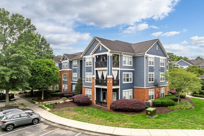
Property Record
100 Sabal Palm Ln, Chesapeake, VA 23320

Property Detail
100 Sabal Palm Ln
0370000003720
PARCEL 3 SUBD PLAT CARROLL M WILLIAMSON PROP 15.00
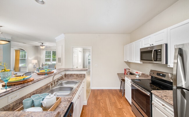
Apartmenthouse5plusunits
CHESAPEAKE
RMF1: MULT
Virginia
B and X Area of moderate flood hazard, usually the area between the limits of the 100-year and 500-year floods.
15 AC
2024
Greenbrier West
2025
Hampton Roads
020912
Virginia Beach-Chesapeake-Norfolk, VA-NC
286,936 SF
NEARBY LISTINGS FOR SALE OR LEASE
-
-
View all Chesapeake listings for sale on LoopNet.com
DEMOGRAPHICS near 100 Sabal Palm Ln
1 mile
3 mile
5 mile
2025 Total Population
9,695
68,802
175,639
2030 Population
9,779
69,588
177,520
Pop Growth 2025-2030
+ 0.87%
+ 1.14%
+ 1.07%
Average Age
42
40
39
2025 Total Households
4,341
27,143
65,618
HH Growth 2025-2030
+ 0.97%
+ 1.20%
+ 1.13%
Median Household Inc
$84,067
$92,876
$97,418
Avg Household Size
2.10
2.50
2.60
2025 Avg HH Vehicles
2.00
2.00
2.00
Median Home Value
$350,076
$380,557
$383,978
Median Year Built
1994
1992
1990
Nearby Places
Map Layers
Map Styles
 Street
 Aerial
Layers
 Traffic
 Biking
Places
Listings with unknown addresses are not visible on the map
- Restaurants
- Banks
- Shops
- Fitness
- Groceries
PUBLIC TRANSPORTATION
COMMUTER RAIL
Norfolk (Northeast Regional - Amtrak)
Drive
Walk
Distance
Norfolk (Northeast Regional - Amtrak)
15 min
9.9 mi
AIRPORT
Norfolk International
Drive
Walk
Distance
Norfolk International
24 min
14.4 mi
Freight Ports
Virginia Port Authority - Portsmouth
Drive
Walk
Distance
Virginia Port Authority - Portsmouth
24 min
13.8 mi
Nearby Properties
Address
Land Use
TOTAL SIZE
Lot Size
Zoning
Address
Land Use
TOTAL SIZE
Lot Size
Zoning
470,098 SF
14.10 AC
O-I: OFFIC
Address
Land Use
TOTAL SIZE
Lot Size
Zoning
405,992 SF
40.22 AC
PUD: PLANN
Address
Land Use
TOTAL SIZE
Lot Size
Zoning
6,820 SF
89.90 AC
R15S: RESI
Address
Land Use
TOTAL SIZE
Lot Size
Zoning
141,461 SF
169.22 AC
C1: CONSER
Address
Land Use
TOTAL SIZE
Lot Size
Zoning
358,908 SF
22.21 AC
MULTI: MUL
Address
Land Use
TOTAL SIZE
Lot Size
Zoning
299,727 SF
170.79 AC
C1: CONSER
Address
Land Use
TOTAL SIZE
Lot Size
Zoning
154,540 SF
1.68 AC
O-I: OFFIC
Address
Land Use
TOTAL SIZE
Lot Size
Zoning
209,403 SF
2.81 AC
PUD: PLANN
Address
Land Use
TOTAL SIZE
Lot Size
Zoning
95,354 SF
39.53 AC
B2: GENERA
Address
Land Use
TOTAL SIZE
Lot Size
Zoning
145,522 SF
15.51 AC
PUD: PLANN
Address
Land Use
TOTAL SIZE
Lot Size
Zoning
168,391 SF
28.39 AC
B2: GENERA
Address
Land Use
TOTAL SIZE
Lot Size
Zoning
218,812 SF
45.15 AC
PUD: PLANN
Address
Land Use
TOTAL SIZE
Lot Size
Zoning
32,163 SF
17.59 AC
MULTI: MUL
Address
Land Use
TOTAL SIZE
Lot Size
Zoning
140,369 SF
10.35 AC
PUD: PLANN
Address
Land Use
TOTAL SIZE
Lot Size
Zoning
26.63 AC
Address
Land Use
TOTAL SIZE
Lot Size
Zoning
92,723 SF
28.83 AC
R6: RESIDE
Address
Land Use
TOTAL SIZE
Lot Size
Zoning
270,962 SF
6.17 AC
MXD-U: MIX
Address
Land Use
TOTAL SIZE
Lot Size
Zoning
401,302 SF
18.74 AC
M2: GENERA
Address
Land Use
TOTAL SIZE
Lot Size
Zoning
277,846 SF
12.50 AC
RMF1: MULT
Address
Land Use
TOTAL SIZE
Lot Size
Zoning
240,547 SF
6.18 AC
PUD: PLANN
Address
Land Use
TOTAL SIZE
Lot Size
Zoning
75,936 SF
11.13 AC
MULTI: MUL
Address
Land Use
TOTAL SIZE
Lot Size
Zoning
127,755 SF
14.68 AC
PUD: PLANN
Address
Land Use
TOTAL SIZE
Lot Size
Zoning
188,683 SF
13.14 AC
O-I: OFFIC
Address
Land Use
TOTAL SIZE
Lot Size
Zoning
162,291 SF
2.98 AC
PUD: PLANN
Address
Land Use
TOTAL SIZE
Lot Size
Zoning
256,041 SF
12.32 AC
RMF1: MULT
Address
Land Use
TOTAL SIZE
Lot Size
Zoning
166,753 SF
1.46 AC
PUD: PLANN
Address
Land Use
TOTAL SIZE
Lot Size
Zoning
196,905 SF
46.84 AC
R15S: RESI
Address
Land Use
TOTAL SIZE
Lot Size
Zoning
67,508 SF
16.63 AC
O-I: OFFIC
Address
Land Use
TOTAL SIZE
Lot Size
Zoning
345,432 SF
17.14 AC
PUD: PLANN
The World's #1 Commercial Real Estate Marketplace
Connect with us
© 2026 CoStar Group
The information above has been obtained from sources believed reliable. While we do not doubt its accuracy we have not verified it and make no guarantee, warranty or representation about it. It is your responsibility to independently confirm its accuracy and completeness. Any projections, opinions, assumptions, or estimates used are for example only and do not represent the current or future performance of the property. The value of this transaction to you depends on tax and other factors which should be evaluated by your tax, financial, and legal advisors. You and your advisors should conduct a careful, independent investigation of the property to determine to your satisfaction the suitability of the property for your needs.