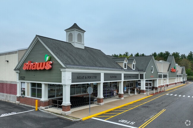
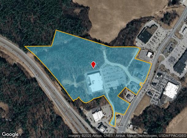
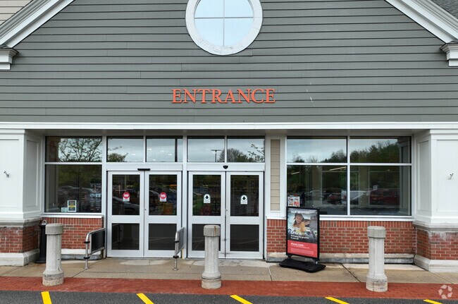
Property Record
100 Shaws Ln, Stratham, NH 03885
NEARBY LISTINGS FOR SALE OR LEASE
-
-
View all Stratham listings for sale on LoopNet.com
Property Detail
100 Shaws Ln
Commercialbuilding
Rockingham
X
New Hampshire
25009C0025F
43.83 AC
2024
Rockingham
2024
Boston
067000
Boston-Cambridge-Newton, MA-NH
72,932 SF
STRH-000004-000010
DEMOGRAPHICS near 100 Shaws Ln
1 Mile
3 Mile
5 Mile
2024 Total Population
857
20,571
36,515
2029 Population
889
21,469
38,016
Pop Growth 2024-2029
+ 3.73%
+ 4.37%
+ 4.11%
Average Age
46
44
45
2024 Total Households
381
8,579
14,909
HH Growth 2024-2029
+ 3.67%
+ 4.31%
+ 4.08%
Median Household Inc
$108,430
$102,710
$110,629
Avg Household Size
2.20
2.30
2.40
2024 Avg HH Vehicles
2.00
2.00
2.00
Median Home Value
$461,940
$480,943
$496,567
Median Year Built
1982
1981
1984
Nearby Places
Map Layers
Map Styles
 Street
 Aerial
- Restaurants
- Banks
- Shops
- Fitness
- Groceries
PUBLIC TRANSPORTATION
COMMUTER RAIL
Exeter (Downeaster - Amtrak)
DRIVE
WALK
Distance
Exeter (Downeaster - Amtrak)
8 min
2.5 mi
AIRPORT
Portsmouth International at Pease
DRIVE
WALK
Distance
Portsmouth International at Pease
24 min
11.7 mi
Manchester Boston Regional
DRIVE
WALK
Distance
Manchester Boston Regional
49 min
34.7 mi
Freight Ports
Port of Boston
DRIVE
WALK
Distance
Port of Boston
74 min
54.0 mi
Nearby Properties
Address
Land Use
TOTAL SIZE
Lot Size
Zoning
Address
Land Use
TOTAL SIZE
Lot Size
Zoning
172,987 SF
89.06 AC
IND
Address
Land Use
TOTAL SIZE
Lot Size
Zoning
19,956 SF
14.55 AC
H
Address
Land Use
TOTAL SIZE
Lot Size
Zoning
177,803 SF
49.86 AC
IND
Address
Land Use
TOTAL SIZE
Lot Size
Zoning
7.36 AC
R-2
Address
Land Use
TOTAL SIZE
Lot Size
Zoning
19,195 SF
21 AC
R-2
Address
Land Use
TOTAL SIZE
Lot Size
Zoning
12,487 SF
7.01 AC
R-5
Address
Land Use
TOTAL SIZE
Lot Size
Zoning
263,990 SF
17.53 AC
I
Address
Land Use
TOTAL SIZE
Lot Size
Zoning
22,614 SF
11.07 AC
R-2
Address
Land Use
TOTAL SIZE
Lot Size
Zoning
1.20 AC
H
Address
Land Use
TOTAL SIZE
Lot Size
Zoning
29,073 SF
1.14 AC
R-2
Address
Land Use
TOTAL SIZE
Lot Size
Zoning
48,348 SF
8.60 AC
R-5
Address
Land Use
TOTAL SIZE
Lot Size
Zoning
29,073 SF
13.46 AC
R-2
Address
Land Use
TOTAL SIZE
Lot Size
Zoning
361,216 SF
28.12 AC
IND
Address
Land Use
TOTAL SIZE
Lot Size
Zoning
0.88 AC
R-2
Address
Land Use
TOTAL SIZE
Lot Size
Zoning
53,360 SF
1.54 AC
C-2
Address
Land Use
TOTAL SIZE
Lot Size
Zoning
2,700 SF
88.89 AC
M
Address
Land Use
TOTAL SIZE
Lot Size
Zoning
84,479 SF
18.74 AC
CT-1
Address
Land Use
TOTAL SIZE
Lot Size
Zoning
17,987 SF
26.90 AC
RES
Address
Land Use
TOTAL SIZE
Lot Size
Zoning
20,593 SF
19.83 AC
R-2
Address
Land Use
TOTAL SIZE
Lot Size
Zoning
64,221 SF
11.70 AC
H
Address
Land Use
TOTAL SIZE
Lot Size
Zoning
160,616 SF
9.03 AC
C-2
Address
Land Use
TOTAL SIZE
Lot Size
Zoning
50,370 SF
10.97 AC
NP
Address
Land Use
TOTAL SIZE
Lot Size
Zoning
22,614 SF
0.29 AC
R-2
Address
Land Use
TOTAL SIZE
Lot Size
Zoning
46,512 SF
1 AC
H
Address
Land Use
TOTAL SIZE
Lot Size
Zoning
69,700 SF
2.46 AC
C-2
Address
Land Use
TOTAL SIZE
Lot Size
Zoning
73,282 SF
15.79 AC
GCBD
Address
Land Use
TOTAL SIZE
Lot Size
Zoning
65,131 SF
8.96 AC
C-2
Address
Land Use
TOTAL SIZE
Lot Size
Zoning
245,000 SF
6.35 AC
H
Address
Land Use
TOTAL SIZE
Lot Size
Zoning
0.64 AC
R-2
The World's #1 Commercial Real Estate Marketplace
Connect with us
© 2025 CoStar Group
The information above has been obtained from sources believed reliable. While we do not doubt its accuracy we have not verified it and make no guarantee, warranty or representation about it. It is your responsibility to independently confirm its accuracy and completeness. Any projections, opinions, assumptions, or estimates used are for example only and do not represent the current or future performance of the property. The value of this transaction to you depends on tax and other factors which should be evaluated by your tax, financial, and legal advisors. You and your advisors should conduct a careful, independent investigation of the property to determine to your satisfaction the suitability of the property for your needs.