Property Record
100 Southcrest Dr, Stockbridge, GA 30281

NEARBY LISTINGS FOR SALE OR LEASE
-
-
View all Stockbridge listings for lease on LoopNet.com
Property Detail
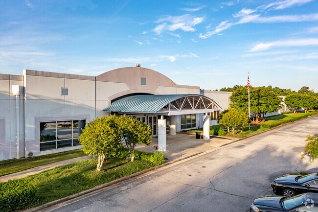
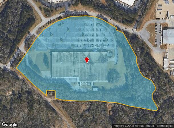
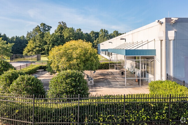
100 Southcrest Dr
Atlanta-Sandy Springs-Roswell, GA
Fortress Investment Group
0012-03-085-001
LAND LOT: 41 /LAND DISTRICT: 12; COMMERCIAL
Commercialnec
Henry
X
Georgia
13063C0092F
0
2025
26.08 AC
2025
S Clayton/Henry Cnty
070115
Atlanta
201,480 SF
DEMOGRAPHICS near 100 Southcrest Dr
1 Mile
3 Mile
5 Mile
2024 Total Population
5,395
57,084
131,123
2029 Population
5,595
58,901
134,610
Pop Growth 2024-2029
+ 3.71%
+ 3.18%
+ 2.66%
Average Age
36
38
38
2024 Total Households
2,095
20,584
47,502
HH Growth 2024-2029
+ 3.10%
+ 3.07%
+ 2.69%
Median Household Inc
$62,990
$61,477
$60,747
Avg Household Size
2.60
2.70
2.70
2024 Avg HH Vehicles
2.00
2.00
2.00
Median Home Value
$202,976
$192,874
$190,437
Median Year Built
1997
1993
1991
Nearby Places
Map Layers
Map Styles
 Street
 Aerial
- Restaurants
- Banks
- Shops
- Fitness
- Groceries
PUBLIC TRANSPORTATION
AIRPORT
Hartsfield - Jackson Atlanta International
DRIVE
WALK
Distance
Hartsfield - Jackson Atlanta International
20 min
13.5 mi
Freight Ports
Georgia Ports - Savannah
DRIVE
WALK
Distance
Georgia Ports - Savannah
257 min
230.4 mi
SALE & LEASE HISTORY
LISTING DATE
SALE/LEASE

Sep 26, 2016
For Lease
Sep 08, 2017
For Lease
Oct 09, 2018
For Sale
Nov 01, 2022
For Lease
Mar 01, 2019
For Sale
Jul 20, 2021
For Lease
Jan 11, 2018
For Sale
Nearby Properties
Address
Land Use
TOTAL SIZE
Lot Size
Zoning
Address
Land Use
TOTAL SIZE
Lot Size
Zoning
368 SF
42.85 AC
RM
Address
Land Use
TOTAL SIZE
Lot Size
Zoning
22,400 SF
45.37 AC
RM
Address
Land Use
TOTAL SIZE
Lot Size
Zoning
35,082 SF
31.82 AC
C3
Address
Land Use
TOTAL SIZE
Lot Size
Zoning
217,289 SF
52.12 AC
OI
Address
Land Use
TOTAL SIZE
Lot Size
Zoning
25.16 AC
RM
Address
Land Use
TOTAL SIZE
Lot Size
Zoning
17,862 SF
30 AC
PD
Address
Land Use
TOTAL SIZE
Lot Size
Zoning
330 SF
33.30 AC
RM
Address
Land Use
TOTAL SIZE
Lot Size
Zoning
1,140 SF
187.84 AC
MX
Address
Land Use
TOTAL SIZE
Lot Size
Zoning
2,426 SF
19.79 AC
RM
Address
Land Use
TOTAL SIZE
Lot Size
Zoning
284 SF
29 AC
RM
Address
Land Use
TOTAL SIZE
Lot Size
Zoning
707,780 SF
85.14 AC
MXI
Address
Land Use
TOTAL SIZE
Lot Size
Zoning
216 SF
31.17 AC
RM
Address
Land Use
TOTAL SIZE
Lot Size
Zoning
20.65 AC
RM
Address
Land Use
TOTAL SIZE
Lot Size
Zoning
200 SF
22 AC
RM
Address
Land Use
TOTAL SIZE
Lot Size
Zoning
87,449 SF
14 AC
MC
Address
Land Use
TOTAL SIZE
Lot Size
Zoning
142,742 SF
27.10 AC
RS110
Address
Land Use
TOTAL SIZE
Lot Size
Zoning
200 SF
25 AC
RM
Address
Land Use
TOTAL SIZE
Lot Size
Zoning
30.90 AC
RS110
Address
Land Use
TOTAL SIZE
Lot Size
Zoning
182 SF
19.46 AC
RM
Address
Land Use
TOTAL SIZE
Lot Size
Zoning
120 SF
26.48 AC
RM
Address
Land Use
TOTAL SIZE
Lot Size
Zoning
200 SF
19 AC
RM
Address
Land Use
TOTAL SIZE
Lot Size
Zoning
84,230 SF
11.56 AC
MCD
Address
Land Use
TOTAL SIZE
Lot Size
Zoning
10.83 AC
GB
Address
Land Use
TOTAL SIZE
Lot Size
Zoning
95,132 SF
20.76 AC
AG
Address
Land Use
TOTAL SIZE
Lot Size
Zoning
158 SF
15.59 AC
RM
Address
Land Use
TOTAL SIZE
Lot Size
Zoning
116 SF
11.42 AC
RM
Address
Land Use
TOTAL SIZE
Lot Size
Zoning
1,638 SF
12.79 AC
RM
Address
Land Use
TOTAL SIZE
Lot Size
Zoning
160 SF
20 AC
RM
Address
Land Use
TOTAL SIZE
Lot Size
Zoning
391,708 SF
20.04 AC
C2
Address
Land Use
TOTAL SIZE
Lot Size
Zoning
127,735 SF
20.74 AC
M1
The World's #1 Commercial Real Estate Marketplace
Connect with us
© 2025 CoStar Group
The information above has been obtained from sources believed reliable. While we do not doubt its accuracy we have not verified it and make no guarantee, warranty or representation about it. It is your responsibility to independently confirm its accuracy and completeness. Any projections, opinions, assumptions, or estimates used are for example only and do not represent the current or future performance of the property. The value of this transaction to you depends on tax and other factors which should be evaluated by your tax, financial, and legal advisors. You and your advisors should conduct a careful, independent investigation of the property to determine to your satisfaction the suitability of the property for your needs.