Property Record
100 Sparks Valley Rd, Sparks Glencoe, MD 21152
Current Lease Availabilities
NEARBY LISTINGS FOR SALE OR LEASE
Property Detail
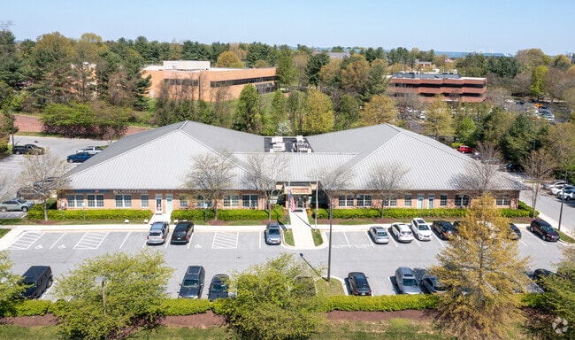
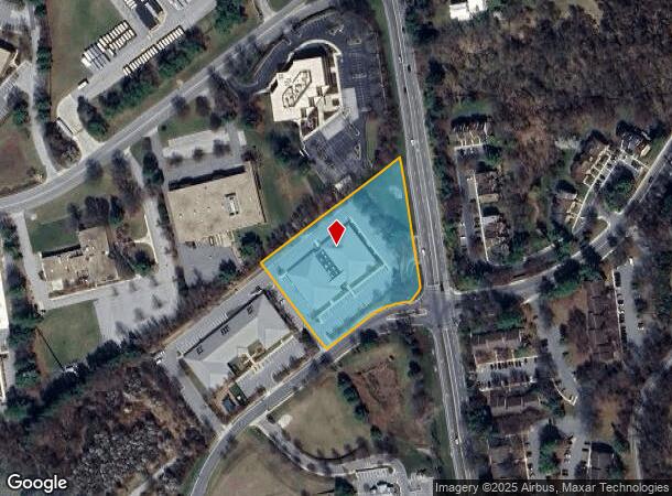
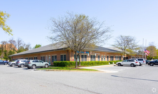
100 Sparks Valley Rd
Baltimore-Columbia-Towson, MD
Sparks Corporate Center
08-2300009926
2.757 AC SPARKS CORPORATE CENTER
Officebuilding
Baltimore
X
Maryland
2400100120G
1
2024
2.76 AC
2025
Route 83 Corridor North
408100
Baltimore
26,300 SF
DEMOGRAPHICS near 100 Sparks Valley Rd
1 Mile
3 Mile
5 Mile
2024 Total Population
4,519
14,806
55,239
2029 Population
4,509
14,673
54,549
Pop Growth 2024-2029
(0.22%)
(0.90%)
(1.25%)
Average Age
44
45
43
2024 Total Households
1,926
6,113
22,898
HH Growth 2024-2029
(0.47%)
(0.90%)
(1.29%)
Median Household Inc
$109,682
$119,788
$100,699
Avg Household Size
2.20
2.30
2.30
2024 Avg HH Vehicles
2.00
2.00
2.00
Median Home Value
$376,255
$419,983
$447,018
Median Year Built
1987
1985
1980
Nearby Places
- Restaurants
- Banks
- Shops
- Fitness
- Groceries
PUBLIC TRANSPORTATION
AIRPORT
Baltimore/Washington International Thurgood Marshall
DRIVE
WALK
Distance
Baltimore/Washington International Thurgood Marshall
46 min
30.9 mi
Freight Ports
Port of Baltimore
DRIVE
WALK
Distance
Port of Baltimore
40 min
22.6 mi
Nearby Properties
Address
Land Use
TOTAL SIZE
Lot Size
Zoning
Address
Land Use
TOTAL SIZE
Lot Size
Zoning
513,056 SF
55.49 AC
BM
Address
Land Use
TOTAL SIZE
Lot Size
Zoning
343,606 SF
19.65 AC
Address
Land Use
TOTAL SIZE
Lot Size
Zoning
595,100 SF
5.73 AC
Address
Land Use
TOTAL SIZE
Lot Size
Zoning
512,317 SF
2.76 AC
BM
Address
Land Use
TOTAL SIZE
Lot Size
Zoning
489,483 SF
84.32 AC
RC4
Address
Land Use
TOTAL SIZE
Lot Size
Zoning
237,800 SF
1.28 AC
BM
Address
Land Use
TOTAL SIZE
Lot Size
Zoning
250,462 SF
185.60 AC
Address
Land Use
TOTAL SIZE
Lot Size
Zoning
330,802 SF
14.81 AC
ML-IM
Address
Land Use
TOTAL SIZE
Lot Size
Zoning
218,049 SF
22.47 AC
Address
Land Use
TOTAL SIZE
Lot Size
Zoning
176,584 SF
31 AC
Address
Land Use
TOTAL SIZE
Lot Size
Zoning
Address
Land Use
TOTAL SIZE
Lot Size
Zoning
138,000 SF
3.09 AC
Address
Land Use
TOTAL SIZE
Lot Size
Zoning
418,286 SF
22.60 AC
ML
Address
Land Use
TOTAL SIZE
Lot Size
Zoning
326,069 SF
9.28 AC
ML-IM
Address
Land Use
TOTAL SIZE
Lot Size
Zoning
143,260 SF
7.31 AC
ML
Address
Land Use
TOTAL SIZE
Lot Size
Zoning
374,156 SF
16.09 AC
MLIM
Address
Land Use
TOTAL SIZE
Lot Size
Zoning
130,720 SF
10.48 AC
ML
Address
Land Use
TOTAL SIZE
Lot Size
Zoning
867,806 SF
48.59 AC
MLIM
Address
Land Use
TOTAL SIZE
Lot Size
Zoning
222,264 SF
5.70 AC
OT
Address
Land Use
TOTAL SIZE
Lot Size
Zoning
103,956 SF
2.77 AC
ML
Address
Land Use
TOTAL SIZE
Lot Size
Zoning
139,797 SF
6.05 AC
ML-IM
Address
Land Use
TOTAL SIZE
Lot Size
Zoning
413,132 SF
44.86 AC
ML-IM
Address
Land Use
TOTAL SIZE
Lot Size
Zoning
289,231 SF
10.23 AC
ML
Address
Land Use
TOTAL SIZE
Lot Size
Zoning
117,646 SF
8.75 AC
ML-IM
Address
Land Use
TOTAL SIZE
Lot Size
Zoning
10.61 AC
DR5.5
Address
Land Use
TOTAL SIZE
Lot Size
Zoning
287,690 SF
8.69 AC
MLR
Address
Land Use
TOTAL SIZE
Lot Size
Zoning
44,304 SF
11.98 AC
ML
Address
Land Use
TOTAL SIZE
Lot Size
Zoning
123,877 SF
13.31 AC
BM
Address
Land Use
TOTAL SIZE
Lot Size
Zoning
46,742 SF
2.33 AC
ML
Address
Land Use
TOTAL SIZE
Lot Size
Zoning
79,272 SF
4.63 AC
ML
The World's #1 Commercial Real Estate Marketplace
Connect with us
© 2025 CoStar Group
The information above has been obtained from sources believed reliable. While we do not doubt its accuracy we have not verified it and make no guarantee, warranty or representation about it. It is your responsibility to independently confirm its accuracy and completeness. Any projections, opinions, assumptions, or estimates used are for example only and do not represent the current or future performance of the property. The value of this transaction to you depends on tax and other factors which should be evaluated by your tax, financial, and legal advisors. You and your advisors should conduct a careful, independent investigation of the property to determine to your satisfaction the suitability of the property for your needs.