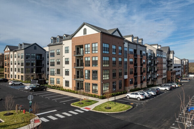
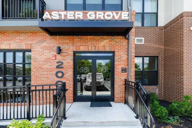
Property Record
100 Spirea Way, Warren, NJ 07059
NEARBY LISTINGS FOR SALE OR LEASE
-
-
View all Warren listings for sale on LoopNet.com
Property Detail
100 Spirea Way
Newark, NJ-PA
Somerset
20-00085-01-00001-02
New Jersey
Apartment
1.1
0
8.64 AC
2025
Outlying Somerset County
052201
Northern New Jersey
DEMOGRAPHICS near 100 Spirea Way
1 Mile
3 Mile
5 Mile
2024 Total Population
1,562
29,857
106,028
2029 Population
1,632
30,163
105,472
Pop Growth 2024-2029
+ 4.48%
+ 1.02%
(0.52%)
Average Age
44
44
42
2024 Total Households
647
10,986
37,072
HH Growth 2024-2029
+ 4.95%
+ 1.08%
(0.53%)
Median Household Inc
$135,787
$156,848
$136,631
Avg Household Size
2.40
2.60
2.80
2024 Avg HH Vehicles
2.00
2.00
2.00
Median Home Value
$582,569
$688,018
$627,559
Median Year Built
1985
1983
1970
Nearby Places
Map Layers
Map Styles
 Street
 Aerial
- Restaurants
- Banks
- Shops
- Fitness
- Groceries
PUBLIC TRANSPORTATION
COMMUTER RAIL
Stirling (Morris & Essex Gladstone Branch - NJ Transit Commuter Rail (NJ Transit))
DRIVE
WALK
Distance
Stirling (Morris & Essex Gladstone Branch - NJ Transit Commuter Rail (NJ Transit))
13 min
7.4 mi
Millington (Morris & Essex Gladstone Branch - NJ Transit Commuter Rail (NJ Transit))
DRIVE
WALK
Distance
Millington (Morris & Essex Gladstone Branch - NJ Transit Commuter Rail (NJ Transit))
14 min
9.9 mi
AIRPORT
Newark Liberty International
DRIVE
WALK
Distance
Newark Liberty International
26 min
22.5 mi
Trenton Mercer
DRIVE
WALK
Distance
Trenton Mercer
73 min
49.5 mi
Freight Ports
New York Container Terminal
DRIVE
WALK
Distance
New York Container Terminal
36 min
25.4 mi
Nearby Properties
Address
Land Use
TOTAL SIZE
Lot Size
Zoning
Address
Land Use
TOTAL SIZE
Lot Size
Zoning
52.31 AC
OR
Address
Land Use
TOTAL SIZE
Lot Size
Zoning
155.97 AC
P4
Address
Land Use
TOTAL SIZE
Lot Size
Zoning
1,976 SF
22.03 AC
B5
Address
Land Use
TOTAL SIZE
Lot Size
Zoning
141.44 AC
P4
Address
Land Use
TOTAL SIZE
Lot Size
Zoning
46.96 AC
OR
Address
Land Use
TOTAL SIZE
Lot Size
Zoning
34.27 AC
R65
Address
Land Use
TOTAL SIZE
Lot Size
Zoning
67.22 AC
R65
Address
Land Use
TOTAL SIZE
Lot Size
Zoning
115.79 AC
OR
Address
Land Use
TOTAL SIZE
Lot Size
Zoning
23.93 AC
B2
Address
Land Use
TOTAL SIZE
Lot Size
Zoning
Address
Land Use
TOTAL SIZE
Lot Size
Zoning
18.66 AC
CR
Address
Land Use
TOTAL SIZE
Lot Size
Zoning
2,800 SF
16.73 AC
R20V
Address
Land Use
TOTAL SIZE
Lot Size
Zoning
13.83 AC
CB
Address
Land Use
TOTAL SIZE
Lot Size
Zoning
11.66 AC
R6
Address
Land Use
TOTAL SIZE
Lot Size
Zoning
1,096 SF
15.12 AC
R5
Address
Land Use
TOTAL SIZE
Lot Size
Zoning
31.58 AC
OR
Address
Land Use
TOTAL SIZE
Lot Size
Zoning
8.09 AC
B3
Address
Land Use
TOTAL SIZE
Lot Size
Zoning
13.07 AC
OR
Address
Land Use
TOTAL SIZE
Lot Size
Zoning
30.84 AC
OR
Address
Land Use
TOTAL SIZE
Lot Size
Zoning
40.36 AC
OR
Address
Land Use
TOTAL SIZE
Lot Size
Zoning
2,765 SF
9.10 AC
R6
Address
Land Use
TOTAL SIZE
Lot Size
Zoning
15.22 AC
OR
Address
Land Use
TOTAL SIZE
Lot Size
Zoning
40.73 AC
OR
Address
Land Use
TOTAL SIZE
Lot Size
Zoning
1,950 SF
10.56 AC
CR
Address
Land Use
TOTAL SIZE
Lot Size
Zoning
15.73 AC
GI
Address
Land Use
TOTAL SIZE
Lot Size
Zoning
7,670 SF
7 AC
R-R
Address
Land Use
TOTAL SIZE
Lot Size
Zoning
5.71 AC
OR
Address
Land Use
TOTAL SIZE
Lot Size
Zoning
22.61 AC
GI
Address
Land Use
TOTAL SIZE
Lot Size
Zoning
The World's #1 Commercial Real Estate Marketplace
Connect with us
© 2026 CoStar Group
The information above has been obtained from sources believed reliable. While we do not doubt its accuracy we have not verified it and make no guarantee, warranty or representation about it. It is your responsibility to independently confirm its accuracy and completeness. Any projections, opinions, assumptions, or estimates used are for example only and do not represent the current or future performance of the property. The value of this transaction to you depends on tax and other factors which should be evaluated by your tax, financial, and legal advisors. You and your advisors should conduct a careful, independent investigation of the property to determine to your satisfaction the suitability of the property for your needs.