Property Record
100 Spring Meadow Dr, Chapel Hill, NC 27517
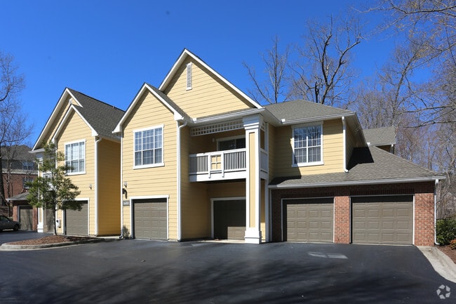

Property Detail
100 Spring Meadow Dr
141889
PROP-ALTA SPRINGS/DBA-ALT A SPRINGS APTS DBA/THE M PL:000137-000149
Gardenaptcourtapt5plusunits
Durham
PDR 6.800
North Carolina
B and X Area of moderate flood hazard, usually the area between the limits of the 100-year and 500-year floods.
43.95 AC
2025
Downing Creek
2025
Raleigh/Durham
002019
Durham-Chapel Hill, NC
9,423 SF
NEARBY LISTINGS FOR SALE OR LEASE
-
-
View all Chapel Hill listings for sale on LoopNet.com
DEMOGRAPHICS near 100 Spring Meadow Dr
1 mile
3 mile
5 mile
2025 Total Population
4,800
38,849
134,389
2030 Population
5,001
40,548
140,141
Pop Growth 2025-2030
+ 4.19%
+ 4.37%
+ 4.28%
Average Age
44
38
38
2025 Total Households
2,266
14,157
55,681
HH Growth 2025-2030
+ 4.41%
+ 5.39%
+ 4.71%
Median Household Inc
$135,945
$110,122
$98,416
Avg Household Size
2.10
2.10
2.20
2025 Avg HH Vehicles
2.00
2.00
2.00
Median Home Value
$683,108
$619,034
$593,850
Median Year Built
2000
1996
1993
Nearby Places
Map Layers
Map Styles
 Street
 Aerial
Layers
 Traffic
 Biking
Places
Listings with unknown addresses are not visible on the map
- Restaurants
- Banks
- Shops
- Fitness
- Groceries
PUBLIC TRANSPORTATION
AIRPORT
Raleigh-Durham International
Drive
Walk
Distance
Raleigh-Durham International
23 min
15.1 mi
Nearby Properties
Address
Land Use
TOTAL SIZE
Lot Size
Zoning
Address
Land Use
TOTAL SIZE
Lot Size
Zoning
104,541 SF
404.01 AC
Address
Land Use
TOTAL SIZE
Lot Size
Zoning
264,710 SF
32.50 AC
R1
Address
Land Use
TOTAL SIZE
Lot Size
Zoning
116,223 SF
34.65 AC
Address
Land Use
TOTAL SIZE
Lot Size
Zoning
244,609 SF
2.72 AC
Address
Land Use
TOTAL SIZE
Lot Size
Zoning
193,344 SF
10.96 AC
MU(D)
Address
Land Use
TOTAL SIZE
Lot Size
Zoning
575,091 SF
3.21 AC
Address
Land Use
TOTAL SIZE
Lot Size
Zoning
81,191 SF
12.33 AC
OI4
Address
Land Use
TOTAL SIZE
Lot Size
Zoning
5,540 SF
90.09 AC
R-1
Address
Land Use
TOTAL SIZE
Lot Size
Zoning
2,748 SF
17.80 AC
R-5-CZD
Address
Land Use
TOTAL SIZE
Lot Size
Zoning
238,990 SF
2.43 AC
Address
Land Use
TOTAL SIZE
Lot Size
Zoning
54,220 SF
41.04 AC
R-1
Address
Land Use
TOTAL SIZE
Lot Size
Zoning
150,677 SF
2.93 AC
Address
Land Use
TOTAL SIZE
Lot Size
Zoning
280,771 SF
6.14 AC
RC(D)
Address
Land Use
TOTAL SIZE
Lot Size
Zoning
9,696 SF
20.94 AC
RS-M(D)
Address
Land Use
TOTAL SIZE
Lot Size
Zoning
144,619 SF
3.22 AC
Address
Land Use
TOTAL SIZE
Lot Size
Zoning
38,300 SF
3.95 AC
MU(D)
Address
Land Use
TOTAL SIZE
Lot Size
Zoning
111,512 SF
5.17 AC
OI(D)
Address
Land Use
TOTAL SIZE
Lot Size
Zoning
135,540 SF
4.34 AC
Address
Land Use
TOTAL SIZE
Lot Size
Zoning
6,846 SF
19.50 AC
RS-M(D)
Address
Land Use
TOTAL SIZE
Lot Size
Zoning
15,816 SF
14.38 AC
RS-M
Address
Land Use
TOTAL SIZE
Lot Size
Zoning
30,300 SF
13.83 AC
Address
Land Use
TOTAL SIZE
Lot Size
Zoning
143,750 SF
1.32 AC
OI3OI4
Address
Land Use
TOTAL SIZE
Lot Size
Zoning
174,922 SF
4.59 AC
OI4
Address
Land Use
TOTAL SIZE
Lot Size
Zoning
313,583 SF
2.93 AC
Address
Land Use
TOTAL SIZE
Lot Size
Zoning
9,057 SF
19.69 AC
R-1
Address
Land Use
TOTAL SIZE
Lot Size
Zoning
24,101 SF
13.85 AC
R5
Address
Land Use
TOTAL SIZE
Lot Size
Zoning
142,236 SF
12.66 AC
OI2
Address
Land Use
TOTAL SIZE
Lot Size
Zoning
419,258 SF
39.50 AC
CC
Address
Land Use
TOTAL SIZE
Lot Size
Zoning
6,609 SF
19.01 AC
RS-M(D)
The World's #1 Commercial Real Estate Marketplace
Connect with us
© 2026 CoStar Group
The information above has been obtained from sources believed reliable. While we do not doubt its accuracy we have not verified it and make no guarantee, warranty or representation about it. It is your responsibility to independently confirm its accuracy and completeness. Any projections, opinions, assumptions, or estimates used are for example only and do not represent the current or future performance of the property. The value of this transaction to you depends on tax and other factors which should be evaluated by your tax, financial, and legal advisors. You and your advisors should conduct a careful, independent investigation of the property to determine to your satisfaction the suitability of the property for your needs.