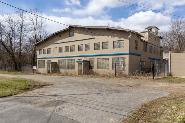
Property Record
100 W Main St, High Bridge, NJ 08829

Save to a Folder
{{folder.Name}}
{{folder.ListingIds.length}} Properties
{{folder.ListingIds.length}} Property
Create a New Folder
Property Detail
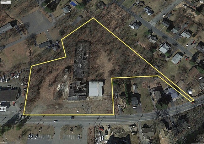
100 W Main St
14-00024-0000-00016
Hunterdon
Industrialgeneral
New Jersey
MUC
16
B and X Area of moderate flood hazard, usually the area between the limits of the 100-year and 500-year floods.
4.38 AC
2025
Hunterdon
2026
Northern New Jersey
010900
Newark, NJ
NEARBY LISTINGS FOR SALE OR LEASE
-
-
View all High Bridge listings for sale on LoopNet.com
DEMOGRAPHICS near 100 W Main St
1 mile
3 mile
5 mile
2025 Total Population
3,827
17,144
34,690
2030 Population
3,922
17,576
35,424
Pop Growth 2025-2030
+ 2.48%
+ 2.52%
+ 2.12%
Average Age
42
43
44
2025 Total Households
1,461
6,495
13,027
HH Growth 2025-2030
+ 2.60%
+ 2.93%
+ 2.41%
Median Household Inc
$129,940
$130,985
$134,219
Avg Household Size
2.50
2.40
2.50
2025 Avg HH Vehicles
2.00
2.00
2.00
Median Home Value
$377,896
$430,743
$464,533
Median Year Built
1968
1978
1978
Nearby Places
Map Layers
Map Styles
 Street
 Aerial
Layers
 Traffic
 Biking
Places
Listings with unknown addresses are not visible on the map
- Restaurants
- Banks
- Shops
- Fitness
- Groceries
PUBLIC TRANSPORTATION
TRANSIT/SUBWAY
High Bridge (Raritan Valley Line - NJ Transit Commuter Rail (NJ Transit))
Drive
Walk
Distance
High Bridge (Raritan Valley Line - NJ Transit Commuter Rail (NJ Transit))
1 min
8 min
0.4 mi
COMMUTER RAIL
High Bridge (Raritan Valley Line - NJ Transit Commuter Rail (NJ Transit))
Drive
Walk
Distance
High Bridge (Raritan Valley Line - NJ Transit Commuter Rail (NJ Transit))
1 min
8 min
0.4 mi
Annandale (Raritan Valley Line - NJ Transit Commuter Rail (NJ Transit))
Drive
Walk
Distance
Annandale (Raritan Valley Line - NJ Transit Commuter Rail (NJ Transit))
7 min
3.9 mi
AIRPORT
Trenton Mercer
Drive
Walk
Distance
Trenton Mercer
50 min
31.4 mi
Lehigh Valley International
Drive
Walk
Distance
Lehigh Valley International
52 min
34.5 mi
Freight Ports
Maher Terminal
Drive
Walk
Distance
Maher Terminal
59 min
46.3 mi
SALE & LEASE HISTORY
LISTING DATE
SALE/LEASE

Feb 01, 2021
For Sale
Nearby Properties
Address
Land Use
TOTAL SIZE
Lot Size
Zoning
Address
Land Use
TOTAL SIZE
Lot Size
Zoning
84.62 AC
ROM1
Address
Land Use
TOTAL SIZE
Lot Size
Zoning
328.35 AC
INS
Address
Land Use
TOTAL SIZE
Lot Size
Zoning
1,740.74 AC
INS
Address
Land Use
TOTAL SIZE
Lot Size
Zoning
49.26 AC
RR4S
Address
Land Use
TOTAL SIZE
Lot Size
Zoning
3,432 SF
24.17 AC
OB3
Address
Land Use
TOTAL SIZE
Lot Size
Zoning
56.97 AC
R3
Address
Land Use
TOTAL SIZE
Lot Size
Zoning
255.40 AC
WM
Address
Land Use
TOTAL SIZE
Lot Size
Zoning
Address
Land Use
TOTAL SIZE
Lot Size
Zoning
215.75 AC
RC
Address
Land Use
TOTAL SIZE
Lot Size
Zoning
36.51 AC
C-N
Address
Land Use
TOTAL SIZE
Lot Size
Zoning
14,194 SF
339.93 AC
RC
Address
Land Use
TOTAL SIZE
Lot Size
Zoning
40.13 AC
AH2
Address
Land Use
TOTAL SIZE
Lot Size
Zoning
Address
Land Use
TOTAL SIZE
Lot Size
Zoning
261.91 AC
RC
Address
Land Use
TOTAL SIZE
Lot Size
Zoning
Address
Land Use
TOTAL SIZE
Lot Size
Zoning
9,408 SF
37 AC
ROM1
Address
Land Use
TOTAL SIZE
Lot Size
Zoning
5.36 AC
PUD
Address
Land Use
TOTAL SIZE
Lot Size
Zoning
52,594 SF
4.58 AC
GA
Address
Land Use
TOTAL SIZE
Lot Size
Zoning
34.80 AC
ROM
Address
Land Use
TOTAL SIZE
Lot Size
Zoning
1.88 AC
OB-2
Address
Land Use
TOTAL SIZE
Lot Size
Zoning
Address
Land Use
TOTAL SIZE
Lot Size
Zoning
10.18 AC
OB-4
Address
Land Use
TOTAL SIZE
Lot Size
Zoning
5.24 AC
C-N
Address
Land Use
TOTAL SIZE
Lot Size
Zoning
2,544 SF
562.37 AC
RC
Address
Land Use
TOTAL SIZE
Lot Size
Zoning
Address
Land Use
TOTAL SIZE
Lot Size
Zoning
1,620 SF
15.85 AC
C2
Address
Land Use
TOTAL SIZE
Lot Size
Zoning
11,467 SF
8.98 AC
OB-2
Address
Land Use
TOTAL SIZE
Lot Size
Zoning
47,400 SF
15.68 AC
I
Address
Land Use
TOTAL SIZE
Lot Size
Zoning
5,052 SF
36.36 AC
RR50
Address
Land Use
TOTAL SIZE
Lot Size
Zoning
14,526 SF
5.03 AC
R-2A
The World's #1 Commercial Real Estate Marketplace
Connect with us
© 2026 CoStar Group
The information above has been obtained from sources believed reliable. While we do not doubt its accuracy we have not verified it and make no guarantee, warranty or representation about it. It is your responsibility to independently confirm its accuracy and completeness. Any projections, opinions, assumptions, or estimates used are for example only and do not represent the current or future performance of the property. The value of this transaction to you depends on tax and other factors which should be evaluated by your tax, financial, and legal advisors. You and your advisors should conduct a careful, independent investigation of the property to determine to your satisfaction the suitability of the property for your needs.