Property Record
100 W Rock Island Rd, Grand Prairie, TX 75050
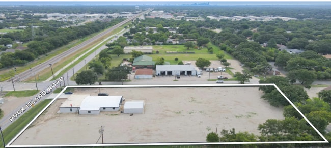
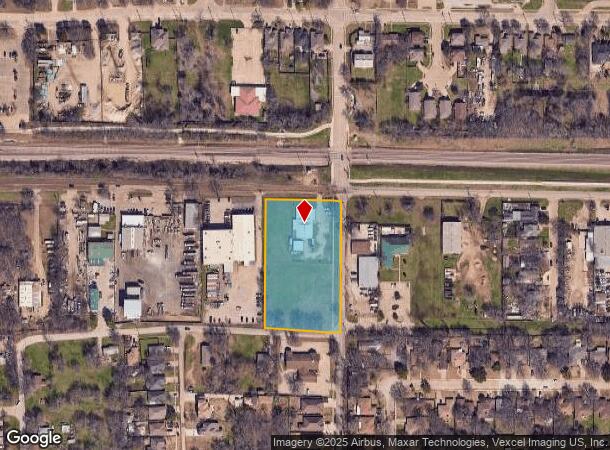
This Property Is For Sale
NEARBY LISTINGS FOR SALE OR LEASE
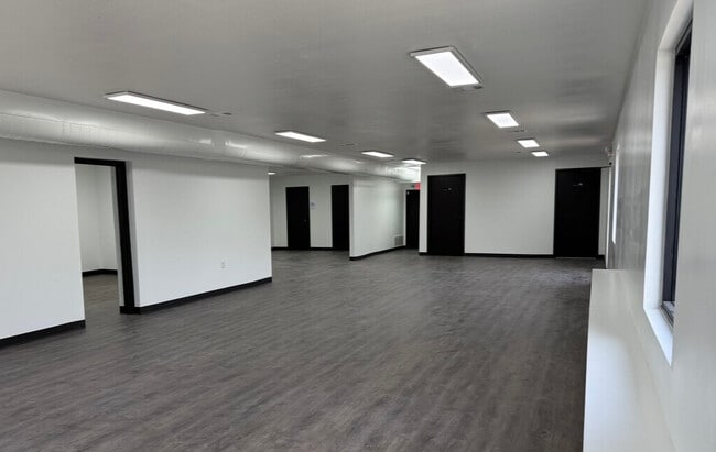
Property Detail
100 W Rock Island Rd
65118382010310000
John C Read
Officebuilding
JOHN C READ ABST 1183 PG 820 TR 31 ACS 2.4233 INT202500090372 DD04282025 CO-DC 1183820103100 5CP11838201
X
Dallas
48439C0235L
Texas
2024
2.23 AC
2025
West Brookhollow
015303
Dallas/Ft Worth
6,068 SF
Dallas-Fort Worth-Arlington, TX
DEMOGRAPHICS near 100 W Rock Island Rd
1 Mile
3 Mile
5 Mile
2024 Total Population
11,268
96,381
256,586
2029 Population
11,149
95,334
260,256
Pop Growth 2024-2029
(1.06%)
(1.09%)
+ 1.43%
Average Age
36
36
36
2024 Total Households
3,753
32,187
94,304
HH Growth 2024-2029
(1.20%)
(1.28%)
+ 1.81%
Median Household Inc
$63,528
$66,396
$68,943
Avg Household Size
2.90
2.90
2.60
2024 Avg HH Vehicles
2.00
2.00
2.00
Median Home Value
$249,672
$263,280
$287,508
Median Year Built
1986
1977
1982
Nearby Places
- Restaurants
- Banks
- Shops
- Fitness
- Groceries
PUBLIC TRANSPORTATION
COMMUTER RAIL
West Irving (TRINITY RAILWAY - Dallas Area Rapid Transit (DART), Trinity Railway Express - Dallas Area Rapid Transit (DART))
DRIVE
WALK
Distance
West Irving (TRINITY RAILWAY - Dallas Area Rapid Transit (DART), Trinity Railway Express - Dallas Area Rapid Transit (DART))
1 min
6 min
0.4 mi
East Tex Yard Limit (TRINITY RAILWAY - Dallas Area Rapid Transit (DART))
DRIVE
WALK
Distance
East Tex Yard Limit (TRINITY RAILWAY - Dallas Area Rapid Transit (DART))
1 min
13 min
0.7 mi
AIRPORT
Dallas-Fort Worth International
DRIVE
WALK
Distance
Dallas-Fort Worth International
14 min
8.5 mi
Dallas Love Field
DRIVE
WALK
Distance
Dallas Love Field
21 min
12.9 mi
Freight Ports
Port of Shreveport
DRIVE
WALK
Distance
Port of Shreveport
231 min
212.1 mi
Nearby Properties
Address
Land Use
TOTAL SIZE
Lot Size
Zoning
Address
Land Use
TOTAL SIZE
Lot Size
Zoning
12,780,691 SF
0.08 AC
Z392
Address
Land Use
TOTAL SIZE
Lot Size
Zoning
516,974 SF
23.81 AC
Address
Land Use
TOTAL SIZE
Lot Size
Zoning
422,880 SF
20.06 AC
Z177
Address
Land Use
TOTAL SIZE
Lot Size
Zoning
738,276 SF
40.57 AC
Z243
Address
Land Use
TOTAL SIZE
Lot Size
Zoning
683,300 SF
40.23 AC
Z01
Address
Land Use
TOTAL SIZE
Lot Size
Zoning
266,586 SF
11.47 AC
Address
Land Use
TOTAL SIZE
Lot Size
Zoning
341,925 SF
17.78 AC
Z49
Address
Land Use
TOTAL SIZE
Lot Size
Zoning
576,000 SF
55.36 AC
Z123
Address
Land Use
TOTAL SIZE
Lot Size
Zoning
336,302 SF
16.74 AC
Z393
Address
Land Use
TOTAL SIZE
Lot Size
Zoning
151,552 SF
16 AC
Z58
Address
Land Use
TOTAL SIZE
Lot Size
Zoning
413,524 SF
24.70 AC
Z198
Address
Land Use
TOTAL SIZE
Lot Size
Zoning
281,078 SF
16.08 AC
Z393
Address
Land Use
TOTAL SIZE
Lot Size
Zoning
585,000 SF
27.06 AC
Z123
Address
Land Use
TOTAL SIZE
Lot Size
Zoning
520,000 SF
28.92 AC
Z123
Address
Land Use
TOTAL SIZE
Lot Size
Zoning
563,300 SF
27.40 AC
Z128
Address
Land Use
TOTAL SIZE
Lot Size
Zoning
500,256 SF
25.64 AC
Z123
Address
Land Use
TOTAL SIZE
Lot Size
Zoning
263,483 SF
11.68 AC
Z393
Address
Land Use
TOTAL SIZE
Lot Size
Zoning
193,212 SF
9.68 AC
Z177
Address
Land Use
TOTAL SIZE
Lot Size
Zoning
257,409 SF
12.31 AC
Address
Land Use
TOTAL SIZE
Lot Size
Zoning
241,780 SF
16.46 AC
RMR2
Address
Land Use
TOTAL SIZE
Lot Size
Zoning
246,720 SF
16.65 AC
Z198
Address
Land Use
TOTAL SIZE
Lot Size
Zoning
391,320 SF
21.78 AC
Address
Land Use
TOTAL SIZE
Lot Size
Zoning
401,600 SF
23.94 AC
Z236
Address
Land Use
TOTAL SIZE
Lot Size
Zoning
643,370 SF
22.95 AC
Z393
Address
Land Use
TOTAL SIZE
Lot Size
Zoning
230,000 SF
12.40 AC
Z393
Address
Land Use
TOTAL SIZE
Lot Size
Zoning
197,458 SF
9.10 AC
Z393
Address
Land Use
TOTAL SIZE
Lot Size
Zoning
423,700 SF
23.29 AC
Z236
Address
Land Use
TOTAL SIZE
Lot Size
Zoning
238,266 SF
10.12 AC
RMR2
Address
Land Use
TOTAL SIZE
Lot Size
Zoning
415,700 SF
22.61 AC
Z393
Address
Land Use
TOTAL SIZE
Lot Size
Zoning
366,350 SF
18.14 AC
Z123
The World's #1 Commercial Real Estate Marketplace
Connect with us
© 2025 CoStar Group
The information above has been obtained from sources believed reliable. While we do not doubt its accuracy we have not verified it and make no guarantee, warranty or representation about it. It is your responsibility to independently confirm its accuracy and completeness. Any projections, opinions, assumptions, or estimates used are for example only and do not represent the current or future performance of the property. The value of this transaction to you depends on tax and other factors which should be evaluated by your tax, financial, and legal advisors. You and your advisors should conduct a careful, independent investigation of the property to determine to your satisfaction the suitability of the property for your needs.