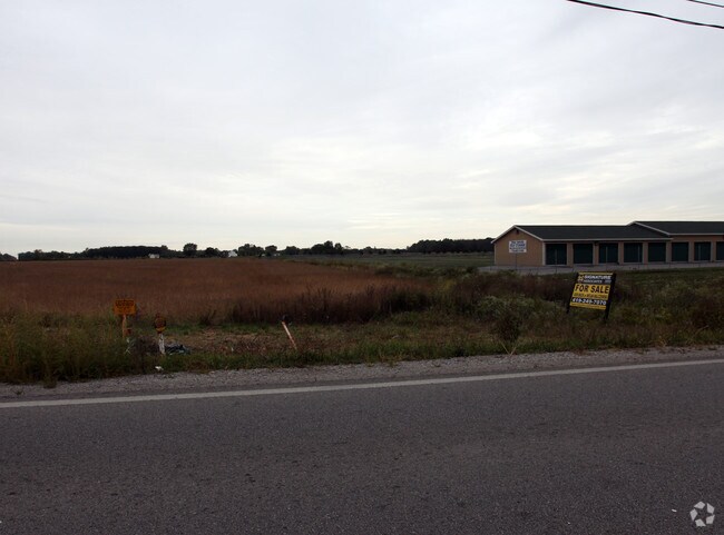
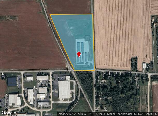
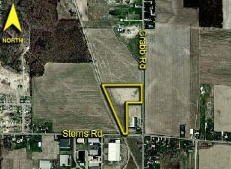
Property Record
100 W Sterns Rd, Temperance, MI 48182
NEARBY LISTINGS FOR SALE OR LEASE
Property Detail
100 W Sterns Rd
02-026-070-00
SEC 26 T8S R7E 20 ACRES S 20 AC OF SE 1/4 OF SEC 26 LYING E OF TOLEDO & ANN ARBOR RR ROW
Publicstorage
Monroe
AE
Michigan
26115C0368E
20 AC
2025
Monroe County
2025
Detroit
833500
Monroe, MI
28,144 SF
DEMOGRAPHICS near 100 W Sterns Rd
1 Mile
3 Mile
5 Mile
2024 Total Population
2,382
29,877
111,030
2029 Population
2,481
30,032
110,133
Pop Growth 2024-2029
+ 4.16%
+ 0.52%
(0.81%)
Average Age
44
42
40
2024 Total Households
1,030
12,739
46,551
HH Growth 2024-2029
+ 4.17%
+ 0.46%
(0.85%)
Median Household Inc
$56,606
$61,054
$57,635
Avg Household Size
2.30
2.30
2.30
2024 Avg HH Vehicles
2.00
2.00
2.00
Median Home Value
$253,025
$167,437
$133,141
Median Year Built
2003
1974
1959
Nearby Places
Map Layers
Map Styles
 Street
 Aerial
- Restaurants
- Banks
- Shops
- Fitness
- Groceries
PUBLIC TRANSPORTATION
COMMUTER RAIL
Toledo (Capitol Limited - Amtrak, Lake Shore Limited - Amtrak)
DRIVE
WALK
Distance
Toledo (Capitol Limited - Amtrak, Lake Shore Limited - Amtrak)
19 min
9.1 mi
AIRPORT
Eugene F Kranz Toledo Express
DRIVE
WALK
Distance
Eugene F Kranz Toledo Express
46 min
27.8 mi
Freight Ports
Port of Toledo
DRIVE
WALK
Distance
Port of Toledo
26 min
13.6 mi
Nearby Properties
Address
Land Use
TOTAL SIZE
Lot Size
Zoning
Address
Land Use
TOTAL SIZE
Lot Size
Zoning
1,972,579 SF
76.32 AC
10-IG
Address
Land Use
TOTAL SIZE
Lot Size
Zoning
693,900 SF
76.32 AC
10-IG
Address
Land Use
TOTAL SIZE
Lot Size
Zoning
76.32 AC
10-IG
Address
Land Use
TOTAL SIZE
Lot Size
Zoning
223,900 SF
17.26 AC
Address
Land Use
TOTAL SIZE
Lot Size
Zoning
163,962 SF
10.13 AC
Address
Land Use
TOTAL SIZE
Lot Size
Zoning
450,000 SF
37.30 AC
Address
Land Use
TOTAL SIZE
Lot Size
Zoning
18.70 AC
Address
Land Use
TOTAL SIZE
Lot Size
Zoning
230,400 SF
18 AC
10-CR
Address
Land Use
TOTAL SIZE
Lot Size
Zoning
6.58 AC
Address
Land Use
TOTAL SIZE
Lot Size
Zoning
Address
Land Use
TOTAL SIZE
Lot Size
Zoning
47,600 SF
5.04 AC
Address
Land Use
TOTAL SIZE
Lot Size
Zoning
87,898 SF
9.17 AC
Address
Land Use
TOTAL SIZE
Lot Size
Zoning
170,528 SF
15 AC
Address
Land Use
TOTAL SIZE
Lot Size
Zoning
302,338 SF
13.97 AC
Address
Land Use
TOTAL SIZE
Lot Size
Zoning
117,635 SF
5.30 AC
Address
Land Use
TOTAL SIZE
Lot Size
Zoning
90,507 SF
9 AC
10-CRSO
Address
Land Use
TOTAL SIZE
Lot Size
Zoning
106.75 AC
AC = AG
Address
Land Use
TOTAL SIZE
Lot Size
Zoning
75,127 SF
5.86 AC
Address
Land Use
TOTAL SIZE
Lot Size
Zoning
123,258 SF
23.59 AC
Address
Land Use
TOTAL SIZE
Lot Size
Zoning
86.45 AC
10-IG
Address
Land Use
TOTAL SIZE
Lot Size
Zoning
125,840 SF
10.50 AC
Address
Land Use
TOTAL SIZE
Lot Size
Zoning
132,601 SF
14.41 AC
10-MX
Address
Land Use
TOTAL SIZE
Lot Size
Zoning
191,297 SF
28.74 AC
10-CRSO
Address
Land Use
TOTAL SIZE
Lot Size
Zoning
2 AC
10-CR
Address
Land Use
TOTAL SIZE
Lot Size
Zoning
123,295 SF
13.22 AC
10-CR
Address
Land Use
TOTAL SIZE
Lot Size
Zoning
48,427 SF
20.29 AC
Address
Land Use
TOTAL SIZE
Lot Size
Zoning
Address
Land Use
TOTAL SIZE
Lot Size
Zoning
61,740 SF
5.91 AC
Address
Land Use
TOTAL SIZE
Lot Size
Zoning
389,812 SF
62.25 AC
10-IG
Address
Land Use
TOTAL SIZE
Lot Size
Zoning
53,306 SF
2 AC
10-CO
The World's #1 Commercial Real Estate Marketplace
Connect with us
© 2026 CoStar Group
The information above has been obtained from sources believed reliable. While we do not doubt its accuracy we have not verified it and make no guarantee, warranty or representation about it. It is your responsibility to independently confirm its accuracy and completeness. Any projections, opinions, assumptions, or estimates used are for example only and do not represent the current or future performance of the property. The value of this transaction to you depends on tax and other factors which should be evaluated by your tax, financial, and legal advisors. You and your advisors should conduct a careful, independent investigation of the property to determine to your satisfaction the suitability of the property for your needs.