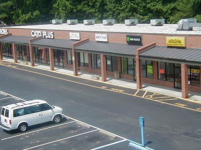
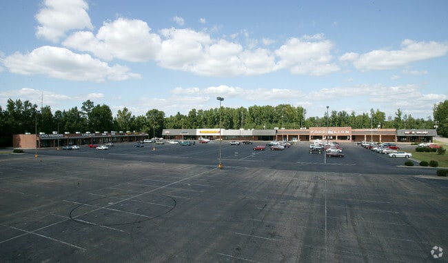
Property Record
100 Winters St, West Point, VA 23181

Property Detail
100 Winters St
63A4-2B
PARCEL B FOODLION ETC STRIP
Commercialnec
King William
MU-1
Virginia
B and X Area of moderate flood hazard, usually the area between the limits of the 100-year and 500-year floods.
11.38 AC
2025
King William County
2025
Richmond VA
950300
Richmond, VA
81,780 SF
NEARBY LISTINGS FOR SALE OR LEASE
DEMOGRAPHICS near 100 Winters St
1 mile
3 mile
5 mile
2025 Total Population
2,870
4,857
6,370
2030 Population
2,999
5,143
6,768
Pop Growth 2025-2030
+ 4.49%
+ 5.89%
+ 6.25%
Average Age
41
42
42
2025 Total Households
1,123
1,870
2,452
HH Growth 2025-2030
+ 4.54%
+ 5.61%
+ 5.87%
Median Household Inc
$79,458
$87,369
$89,092
Avg Household Size
2.50
2.50
2.50
2025 Avg HH Vehicles
2.00
2.00
2.00
Median Home Value
$265,665
$279,872
$284,252
Median Year Built
1975
1977
1979
Nearby Places
Map Layers
Map Styles
 Street
 Aerial
Layers
 Traffic
 Biking
Places
Listings with unknown addresses are not visible on the map
- Restaurants
- Banks
- Shops
- Fitness
- Groceries
PUBLIC TRANSPORTATION
AIRPORT
Richmond International
Drive
Walk
Distance
Richmond International
44 min
34.3 mi
Freight Ports
Virginia Port Authority - Richmond
Drive
Walk
Distance
Virginia Port Authority - Richmond
58 min
43.6 mi
SALE & LEASE HISTORY
LISTING DATE
SALE/LEASE

Mar 17, 2017
For Lease
Nearby Properties
Address
Land Use
TOTAL SIZE
Lot Size
Zoning
Address
Land Use
TOTAL SIZE
Lot Size
Zoning
85,500 SF
42 AC
R-1
Address
Land Use
TOTAL SIZE
Lot Size
Zoning
23,465 SF
14.12 AC
R-1
Address
Land Use
TOTAL SIZE
Lot Size
Zoning
12,960 SF
8.24 AC
M-2
Address
Land Use
TOTAL SIZE
Lot Size
Zoning
1.30 AC
M-2
Address
Land Use
TOTAL SIZE
Lot Size
Zoning
7,188 SF
6.67 AC
BUS
Address
Land Use
TOTAL SIZE
Lot Size
Zoning
31,183 SF
33.72 AC
M
Address
Land Use
TOTAL SIZE
Lot Size
Zoning
29,920 SF
0.14 AC
B-1
Address
Land Use
TOTAL SIZE
Lot Size
Zoning
5,400 SF
15.32 AC
M-1
Address
Land Use
TOTAL SIZE
Lot Size
Zoning
4,026 SF
6.93 AC
BUS
Address
Land Use
TOTAL SIZE
Lot Size
Zoning
4,290 SF
1.62 AC
B-1
Address
Land Use
TOTAL SIZE
Lot Size
Zoning
8,181 SF
7 AC
INDUSTRIAL
Address
Land Use
TOTAL SIZE
Lot Size
Zoning
11,732 SF
10 AC
GENERAL BU
Address
Land Use
TOTAL SIZE
Lot Size
Zoning
310.75 AC
A1
Address
Land Use
TOTAL SIZE
Lot Size
Zoning
8,400 SF
30.50 AC
INDUSTRIAL
Address
Land Use
TOTAL SIZE
Lot Size
Zoning
4,198 SF
2.15 AC
BUS
Address
Land Use
TOTAL SIZE
Lot Size
Zoning
18,853 SF
4.89 AC
M-1
Address
Land Use
TOTAL SIZE
Lot Size
Zoning
8,500 SF
0.27 AC
B-1
Address
Land Use
TOTAL SIZE
Lot Size
Zoning
7,208 SF
0.13 AC
R-4
Address
Land Use
TOTAL SIZE
Lot Size
Zoning
4,028 SF
0.18 AC
B-1
Address
Land Use
TOTAL SIZE
Lot Size
Zoning
20,856 SF
0.45 AC
SD-1
Address
Land Use
TOTAL SIZE
Lot Size
Zoning
2,385 SF
93.10 AC
R-1
Address
Land Use
TOTAL SIZE
Lot Size
Zoning
4,473 SF
0.13 AC
B-2
Address
Land Use
TOTAL SIZE
Lot Size
Zoning
1,152 SF
4.64 AC
A-C
Address
Land Use
TOTAL SIZE
Lot Size
Zoning
5,682 SF
0.25 AC
B-1
Address
Land Use
TOTAL SIZE
Lot Size
Zoning
121 AC
A1
Address
Land Use
TOTAL SIZE
Lot Size
Zoning
3,029 SF
B-1
Address
Land Use
TOTAL SIZE
Lot Size
Zoning
4,107 SF
0.72 AC
R-1
The World's #1 Commercial Real Estate Marketplace
Connect with us
© 2026 CoStar Group
The information above has been obtained from sources believed reliable. While we do not doubt its accuracy we have not verified it and make no guarantee, warranty or representation about it. It is your responsibility to independently confirm its accuracy and completeness. Any projections, opinions, assumptions, or estimates used are for example only and do not represent the current or future performance of the property. The value of this transaction to you depends on tax and other factors which should be evaluated by your tax, financial, and legal advisors. You and your advisors should conduct a careful, independent investigation of the property to determine to your satisfaction the suitability of the property for your needs.