Property Record
100 Woodcrest Dr, Saint Augustine, FL 32084
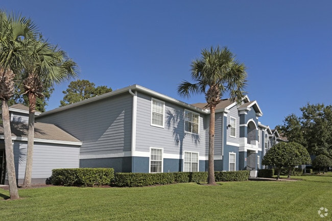


Property Detail
100 Woodcrest Dr
102820-0010
1-1 TRI PT OF DELESPINE GRANT & PT OF LOT 8 SEC1-T7S-R29E LYING E OF VARELLA AVE W OF CR16-A & N OF 70FT SCHOOLHOUSE RD (EX ANY PT IN R/W OF RDS) & (EX NLY TRI PT IN OR1205/1814) OR4148/1657
Multifamilydwelling
ST. JOHNS
PSD
Florida
AE The base floodplain where base flood elevations are provided. AE Zones are now used on new format FIRMs instead of A1-A30 Zones.
8
2025
17.38 AC
2026
Greater St Augustine
020903
Jacksonville (Florida)
93,765 SF
Jacksonville, FL
NEARBY LISTINGS FOR SALE OR LEASE
-
-
View all Saint Augustine listings for sale on LoopNet.com
DEMOGRAPHICS near 100 Woodcrest Dr
1 mile
3 mile
5 mile
2025 Total Population
6,013
33,454
57,788
2030 Population
6,998
39,027
67,505
Pop Growth 2025-2030
+ 16.38%
+ 16.66%
+ 16.81%
Average Age
43
44
45
2025 Total Households
2,561
14,191
24,791
HH Growth 2025-2030
+ 16.75%
+ 17.14%
+ 17.27%
Median Household Inc
$76,125
$78,150
$80,395
Avg Household Size
2.30
2.20
2.20
2025 Avg HH Vehicles
2.00
2.00
2.00
Median Home Value
$392,124
$415,596
$424,276
Median Year Built
2005
2000
2000
Nearby Places
Map Layers
Map Styles
 Street
 Aerial
Layers
 Traffic
 Biking
Places
Listings with unknown addresses are not visible on the map
- Restaurants
- Banks
- Shops
- Fitness
- Groceries
Nearby Properties
Address
Land Use
TOTAL SIZE
Lot Size
Zoning
Address
Land Use
TOTAL SIZE
Lot Size
Zoning
322,553 SF
10.54 AC
Address
Land Use
TOTAL SIZE
Lot Size
Zoning
198,608 SF
54.13 AC
AD
Address
Land Use
TOTAL SIZE
Lot Size
Zoning
323,748 SF
4.62 AC
Address
Land Use
TOTAL SIZE
Lot Size
Zoning
657,013 SF
77.07 AC
Address
Land Use
TOTAL SIZE
Lot Size
Zoning
274,007 SF
22.11 AC
Address
Land Use
TOTAL SIZE
Lot Size
Zoning
343,365 SF
127.66 AC
Address
Land Use
TOTAL SIZE
Lot Size
Zoning
422,807 SF
80.60 AC
OR
Address
Land Use
TOTAL SIZE
Lot Size
Zoning
250,683 SF
41.99 AC
PS
Address
Land Use
TOTAL SIZE
Lot Size
Zoning
312,840 SF
19.29 AC
CG
Address
Land Use
TOTAL SIZE
Lot Size
Zoning
325,487 SF
19.20 AC
PS
Address
Land Use
TOTAL SIZE
Lot Size
Zoning
286,292 SF
16.55 AC
Address
Land Use
TOTAL SIZE
Lot Size
Zoning
320,571 SF
15.91 AC
Address
Land Use
TOTAL SIZE
Lot Size
Zoning
44,656 SF
16.56 AC
Address
Land Use
TOTAL SIZE
Lot Size
Zoning
Address
Land Use
TOTAL SIZE
Lot Size
Zoning
167,115 SF
1.58 AC
TCMU
Address
Land Use
TOTAL SIZE
Lot Size
Zoning
184,752 SF
7.80 AC
Address
Land Use
TOTAL SIZE
Lot Size
Zoning
100,199 SF
1.56 AC
Address
Land Use
TOTAL SIZE
Lot Size
Zoning
53,451 SF
1.23 AC
CM2
Address
Land Use
TOTAL SIZE
Lot Size
Zoning
76,020 SF
2.22 AC
CM2
Address
Land Use
TOTAL SIZE
Lot Size
Zoning
115,134 SF
4.54 AC
Address
Land Use
TOTAL SIZE
Lot Size
Zoning
132,489 SF
74.83 AC
AD
Address
Land Use
TOTAL SIZE
Lot Size
Zoning
117,811 SF
1.17 AC
HP4
Address
Land Use
TOTAL SIZE
Lot Size
Zoning
154,685 SF
82.60 AC
RS3
Address
Land Use
TOTAL SIZE
Lot Size
Zoning
53,172 SF
2.65 AC
Address
Land Use
TOTAL SIZE
Lot Size
Zoning
138,677 SF
4.08 AC
Address
Land Use
TOTAL SIZE
Lot Size
Zoning
116,861 SF
18.08 AC
PS
Address
Land Use
TOTAL SIZE
Lot Size
Zoning
74,085 SF
2.86 AC
Address
Land Use
TOTAL SIZE
Lot Size
Zoning
Address
Land Use
TOTAL SIZE
Lot Size
Zoning
60,889 SF
2.57 AC
CHT
Address
Land Use
TOTAL SIZE
Lot Size
Zoning
44,727 SF
27.26 AC
PS
The World's #1 Commercial Real Estate Marketplace
Connect with us
© 2026 CoStar Group
The information above has been obtained from sources believed reliable. While we do not doubt its accuracy we have not verified it and make no guarantee, warranty or representation about it. It is your responsibility to independently confirm its accuracy and completeness. Any projections, opinions, assumptions, or estimates used are for example only and do not represent the current or future performance of the property. The value of this transaction to you depends on tax and other factors which should be evaluated by your tax, financial, and legal advisors. You and your advisors should conduct a careful, independent investigation of the property to determine to your satisfaction the suitability of the property for your needs.