Property Record
1000 Beltline Rd Sw, Decatur, AL 35601
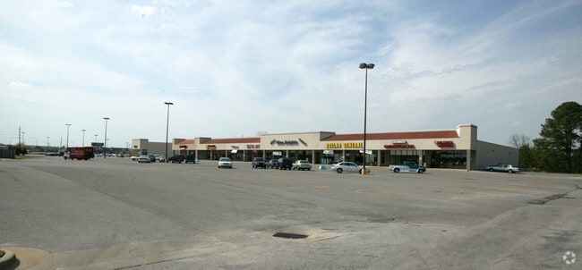


Property Detail
1000 Beltline Rd Sw
Decatur, AL
LOT 1 PLUMTREE CENTER SUBDIVISION MAP BOOK 2012 PAGE 4 SEC 36, T5S, R5W
02-07-36-4-003-092.003
Morgan
Storebuilding
Alabama
B and X Area of moderate flood hazard, usually the area between the limits of the 100-year and 500-year floods.
1
2025
6.90 AC
2024
Alabama North Area
000900
Other Market Areas
78,999 SF
NEARBY LISTINGS FOR SALE OR LEASE
DEMOGRAPHICS near 1000 Beltline Rd Sw
1 mile
3 mile
5 mile
2024 Total Population
8,614
42,810
61,498
2029 Population
8,656
43,306
62,542
Pop Growth 2024-2029
+ 0.49%
+ 1.16%
+ 1.70%
Average Age
40
40
40
2024 Total Households
3,747
17,526
24,987
HH Growth 2024-2029
+ 0.51%
+ 1.20%
+ 1.77%
Median Household Inc
$57,504
$63,139
$66,126
Avg Household Size
2.20
2.40
2.30
2024 Avg HH Vehicles
2.00
2.00
2.00
Median Home Value
$206,444
$198,093
$208,900
Median Year Built
1983
1979
1977
Nearby Places
Map Layers
Map Styles
 Street
 Aerial
Transit
 Traffic
 Biking
Places
Listings with unknown addresses are not visible on the map
- Restaurants
- Banks
- Shops
- Fitness
- Groceries
PUBLIC TRANSPORTATION
AIRPORT
Huntsville International-Carl T Jones Field
Drive
Walk
Distance
Huntsville International-Carl T Jones Field
32 min
19.9 mi
Freight Ports
Port of Mobile
Drive
Walk
Distance
Port of Mobile
368 min
335.0 mi
SALE & LEASE HISTORY
LISTING DATE
SALE/LEASE

Jan 21, 2025
For Lease
Nearby Properties
Address
Land Use
TOTAL SIZE
Lot Size
Zoning
Address
Land Use
TOTAL SIZE
Lot Size
Zoning
103,569 SF
6.69 AC
Address
Land Use
TOTAL SIZE
Lot Size
Zoning
35,727 SF
10 AC
Address
Land Use
TOTAL SIZE
Lot Size
Zoning
157,720 SF
22 AC
Address
Land Use
TOTAL SIZE
Lot Size
Zoning
48,364 SF
1.80 AC
Address
Land Use
TOTAL SIZE
Lot Size
Zoning
54,544 SF
6.53 AC
Address
Land Use
TOTAL SIZE
Lot Size
Zoning
128,239 SF
7.10 AC
Address
Land Use
TOTAL SIZE
Lot Size
Zoning
51,958 SF
14 AC
Address
Land Use
TOTAL SIZE
Lot Size
Zoning
106,165 SF
0.80 AC
Address
Land Use
TOTAL SIZE
Lot Size
Zoning
377,685 SF
17 AC
Address
Land Use
TOTAL SIZE
Lot Size
Zoning
81,682 SF
13 AC
Address
Land Use
TOTAL SIZE
Lot Size
Zoning
205,279 SF
25.45 AC
Address
Land Use
TOTAL SIZE
Lot Size
Zoning
135,440 SF
6.76 AC
Address
Land Use
TOTAL SIZE
Lot Size
Zoning
54,352 SF
10.70 AC
Address
Land Use
TOTAL SIZE
Lot Size
Zoning
40,712 SF
12 AC
Address
Land Use
TOTAL SIZE
Lot Size
Zoning
2,546 SF
9.30 AC
Address
Land Use
TOTAL SIZE
Lot Size
Zoning
64,449 SF
12 AC
Address
Land Use
TOTAL SIZE
Lot Size
Zoning
19,239 SF
4.50 AC
Address
Land Use
TOTAL SIZE
Lot Size
Zoning
4,865 SF
22 AC
Address
Land Use
TOTAL SIZE
Lot Size
Zoning
4,181 SF
6.70 AC
Address
Land Use
TOTAL SIZE
Lot Size
Zoning
49,384 SF
1.07 AC
Address
Land Use
TOTAL SIZE
Lot Size
Zoning
81,042 SF
2.39 AC
Address
Land Use
TOTAL SIZE
Lot Size
Zoning
52,800 SF
14.50 AC
Address
Land Use
TOTAL SIZE
Lot Size
Zoning
42,197 SF
3.75 AC
Address
Land Use
TOTAL SIZE
Lot Size
Zoning
31,473 SF
2.90 AC
Address
Land Use
TOTAL SIZE
Lot Size
Zoning
19,198 SF
15 AC
Address
Land Use
TOTAL SIZE
Lot Size
Zoning
53,680 SF
0.50 AC
Address
Land Use
TOTAL SIZE
Lot Size
Zoning
55,283 SF
4.48 AC
Address
Land Use
TOTAL SIZE
Lot Size
Zoning
175,314 SF
Address
Land Use
TOTAL SIZE
Lot Size
Zoning
33,878 SF
3.52 AC
The World's #1 Commercial Real Estate Marketplace
Connect with us
© 2026 CoStar Group
The information above has been obtained from sources believed reliable. While we do not doubt its accuracy we have not verified it and make no guarantee, warranty or representation about it. It is your responsibility to independently confirm its accuracy and completeness. Any projections, opinions, assumptions, or estimates used are for example only and do not represent the current or future performance of the property. The value of this transaction to you depends on tax and other factors which should be evaluated by your tax, financial, and legal advisors. You and your advisors should conduct a careful, independent investigation of the property to determine to your satisfaction the suitability of the property for your needs.