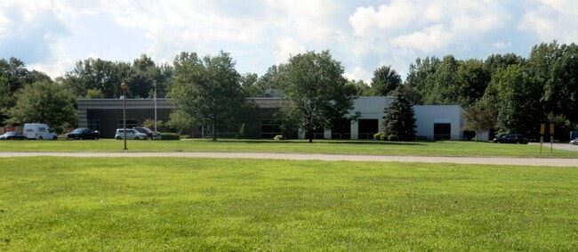
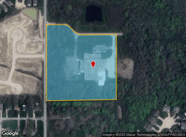
Property Record
1000 Bacon Rd, Painesville, OH 44077
NEARBY LISTINGS FOR SALE OR LEASE
-
-
View all Painesville listings for lease on LoopNet.com
Property Detail
1000 Bacon Rd
Cleveland-Elyria, OH
I
11-B-046-0-00-006
LOT 2 TRACT 1
Industrialgeneral
Lake
X
Ohio
39085C0039G
2
0
10.21 AC
2025
East Lake County
204800
Cleveland
59,922 SF
DEMOGRAPHICS near 1000 Bacon Rd
1 Mile
3 Mile
5 Mile
2024 Total Population
3,856
14,482
41,441
2029 Population
3,869
14,458
41,392
Pop Growth 2024-2029
+ 0.34%
(0.17%)
(0.12%)
Average Age
43
41
41
2024 Total Households
1,578
5,631
16,339
HH Growth 2024-2029
+ 0.44%
(0.12%)
(0.15%)
Median Household Inc
$83,890
$75,799
$65,400
Avg Household Size
2.40
2.50
2.40
2024 Avg HH Vehicles
2.00
2.00
2.00
Median Home Value
$170,279
$169,715
$163,667
Median Year Built
1999
1980
1971
Nearby Places
Map Layers
Map Styles
 Street
 Aerial
- Restaurants
- Banks
- Shops
- Fitness
- Groceries
PUBLIC TRANSPORTATION
AIRPORT
Cleveland-Hopkins International
DRIVE
WALK
Distance
Cleveland-Hopkins International
65 min
46.4 mi
SALE & LEASE HISTORY
LISTING DATE
SALE/LEASE

Sep 28, 2020
For Sale
Jan 12, 2021
For Lease
Nearby Properties
Address
Land Use
TOTAL SIZE
Lot Size
Zoning
Address
Land Use
TOTAL SIZE
Lot Size
Zoning
47,436 SF
16.83 AC
R1
Address
Land Use
TOTAL SIZE
Lot Size
Zoning
50,644 SF
250.64 AC
I-2
Address
Land Use
TOTAL SIZE
Lot Size
Zoning
74,502 SF
6.35 AC
R-1
Address
Land Use
TOTAL SIZE
Lot Size
Zoning
142,593 SF
11.81 AC
Address
Land Use
TOTAL SIZE
Lot Size
Zoning
14,400 SF
173.24 AC
I1
Address
Land Use
TOTAL SIZE
Lot Size
Zoning
1,099,977 SF
142.16 AC
I-2
Address
Land Use
TOTAL SIZE
Lot Size
Zoning
134,697 SF
8.72 AC
Address
Land Use
TOTAL SIZE
Lot Size
Zoning
217.09 AC
Address
Land Use
TOTAL SIZE
Lot Size
Zoning
95,628 SF
8.95 AC
R-3
Address
Land Use
TOTAL SIZE
Lot Size
Zoning
50,908 SF
71.84 AC
I-2
Address
Land Use
TOTAL SIZE
Lot Size
Zoning
100,142 SF
25.07 AC
Address
Land Use
TOTAL SIZE
Lot Size
Zoning
179,516 SF
28.69 AC
I2
Address
Land Use
TOTAL SIZE
Lot Size
Zoning
50,580 SF
7.26 AC
B
Address
Land Use
TOTAL SIZE
Lot Size
Zoning
233.79 AC
R-1
Address
Land Use
TOTAL SIZE
Lot Size
Zoning
87,433 SF
55.12 AC
I-2
Address
Land Use
TOTAL SIZE
Lot Size
Zoning
37,500 SF
20 AC
I-2
Address
Land Use
TOTAL SIZE
Lot Size
Zoning
55,480 SF
3 AC
Address
Land Use
TOTAL SIZE
Lot Size
Zoning
49,862 SF
12.69 AC
I-2
Address
Land Use
TOTAL SIZE
Lot Size
Zoning
70,837 SF
12.26 AC
B-3
Address
Land Use
TOTAL SIZE
Lot Size
Zoning
50,746 SF
7.76 AC
Address
Land Use
TOTAL SIZE
Lot Size
Zoning
16,466 SF
4.18 AC
Address
Land Use
TOTAL SIZE
Lot Size
Zoning
48,632 SF
3.72 AC
B-4
Address
Land Use
TOTAL SIZE
Lot Size
Zoning
43,160 SF
2.34 AC
R3
Address
Land Use
TOTAL SIZE
Lot Size
Zoning
50.90 AC
Address
Land Use
TOTAL SIZE
Lot Size
Zoning
50.90 AC
I1
Address
Land Use
TOTAL SIZE
Lot Size
Zoning
25,000 SF
3 AC
Address
Land Use
TOTAL SIZE
Lot Size
Zoning
95.70 AC
Address
Land Use
TOTAL SIZE
Lot Size
Zoning
18,488 SF
0.96 AC
R-2
Address
Land Use
TOTAL SIZE
Lot Size
Zoning
10,410 SF
16.93 AC
S-1
The World's #1 Commercial Real Estate Marketplace
Connect with us
© 2026 CoStar Group
The information above has been obtained from sources believed reliable. While we do not doubt its accuracy we have not verified it and make no guarantee, warranty or representation about it. It is your responsibility to independently confirm its accuracy and completeness. Any projections, opinions, assumptions, or estimates used are for example only and do not represent the current or future performance of the property. The value of this transaction to you depends on tax and other factors which should be evaluated by your tax, financial, and legal advisors. You and your advisors should conduct a careful, independent investigation of the property to determine to your satisfaction the suitability of the property for your needs.