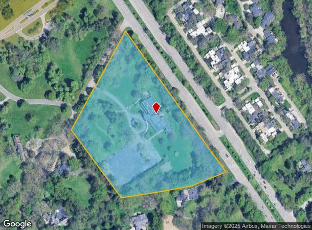
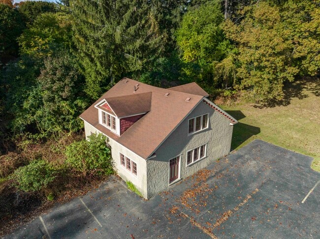
Property Record
1000 Cranbrook Rd, Bloomfield Hills, MI 48304

This Property Is For Sale
NEARBY LISTINGS FOR SALE OR LEASE
Property Detail
1000 Cranbrook Rd
Detroit-Warren-Dearborn, MI
Uplands
19-14-376-001
T2N, R10E, SEC 14 & 23 UPLANDS LOTS 1 TO 5 INCL
Residentialacreage
Oakland
X
Michigan
26125C0528F
1-5
0
8.99 AC
2025
Bloomfield
152000
Detroit
DEMOGRAPHICS near 1000 Cranbrook Rd
1 Mile
3 Mile
5 Mile
2024 Total Population
2,948
60,615
188,309
2029 Population
3,051
61,975
193,822
Pop Growth 2024-2029
+ 3.49%
+ 2.24%
+ 2.93%
Average Age
47
44
43
2024 Total Households
1,074
23,392
76,785
HH Growth 2024-2029
+ 3.63%
+ 2.35%
+ 2.98%
Median Household Inc
$184,999
$167,077
$112,193
Avg Household Size
2.50
2.50
2.40
2024 Avg HH Vehicles
2.00
2.00
2.00
Median Home Value
$942,737
$681,219
$463,371
Median Year Built
1973
1966
1969
Nearby Places
Map Layers
Map Styles
 Street
 Aerial
- Restaurants
- Banks
- Shops
- Fitness
- Groceries
PUBLIC TRANSPORTATION
COMMUTER RAIL
Troy Amtrak Station (Wolverine - Amtrak)
DRIVE
WALK
Distance
Troy Amtrak Station (Wolverine - Amtrak)
9 min
4.3 mi
Pontiac Amtrak Station (Wolverine - Amtrak)
DRIVE
WALK
Distance
Pontiac Amtrak Station (Wolverine - Amtrak)
11 min
5.6 mi
AIRPORT
Detroit Metro Wayne County
DRIVE
WALK
Distance
Detroit Metro Wayne County
54 min
33.1 mi
Windsor International
DRIVE
WALK
Distance
Windsor International
55 min
33.5 mi
Freight Ports
Port of Toledo
DRIVE
WALK
Distance
Port of Toledo
103 min
75.2 mi
Nearby Properties
Address
Land Use
TOTAL SIZE
Lot Size
Zoning
Address
Land Use
TOTAL SIZE
Lot Size
Zoning
399,735 SF
19.71 AC
B2
Address
Land Use
TOTAL SIZE
Lot Size
Zoning
224,766 SF
19.92 AC
B2
Address
Land Use
TOTAL SIZE
Lot Size
Zoning
711,360 SF
43.86 AC
Address
Land Use
TOTAL SIZE
Lot Size
Zoning
111,030 SF
0.97 AC
BI
Address
Land Use
TOTAL SIZE
Lot Size
Zoning
149,395 SF
1.02 AC
BI
Address
Land Use
TOTAL SIZE
Lot Size
Zoning
143,160 SF
0.84 AC
BI
Address
Land Use
TOTAL SIZE
Lot Size
Zoning
236,140 SF
1.67 AC
BI
Address
Land Use
TOTAL SIZE
Lot Size
Zoning
99,661 SF
0.62 AC
Address
Land Use
TOTAL SIZE
Lot Size
Zoning
160,796 SF
1.84 AC
Address
Land Use
TOTAL SIZE
Lot Size
Zoning
365,104 SF
2.03 AC
Address
Land Use
TOTAL SIZE
Lot Size
Zoning
301,728 SF
2.83 AC
B2
Address
Land Use
TOTAL SIZE
Lot Size
Zoning
289,110 SF
6.07 AC
BI
Address
Land Use
TOTAL SIZE
Lot Size
Zoning
83,244 SF
0.38 AC
Address
Land Use
TOTAL SIZE
Lot Size
Zoning
101,409 SF
5.90 AC
Address
Land Use
TOTAL SIZE
Lot Size
Zoning
206,590 SF
6.14 AC
RI
Address
Land Use
TOTAL SIZE
Lot Size
Zoning
203,643 SF
9.85 AC
IV
Address
Land Use
TOTAL SIZE
Lot Size
Zoning
242,512 SF
6.60 AC
BI
Address
Land Use
TOTAL SIZE
Lot Size
Zoning
96,774 SF
6.34 AC
BI
Address
Land Use
TOTAL SIZE
Lot Size
Zoning
154,370 SF
8.80 AC
BI
Address
Land Use
TOTAL SIZE
Lot Size
Zoning
218,023 SF
21.80 AC
AI
Address
Land Use
TOTAL SIZE
Lot Size
Zoning
84,711 SF
5.05 AC
BI
Address
Land Use
TOTAL SIZE
Lot Size
Zoning
454,573 SF
Address
Land Use
TOTAL SIZE
Lot Size
Zoning
225,890 SF
10.10 AC
OM
Address
Land Use
TOTAL SIZE
Lot Size
Zoning
80,334 SF
0.57 AC
BI
Address
Land Use
TOTAL SIZE
Lot Size
Zoning
267,393 SF
11.11 AC
BI
Address
Land Use
TOTAL SIZE
Lot Size
Zoning
79,935 SF
1.02 AC
BI
Address
Land Use
TOTAL SIZE
Lot Size
Zoning
109,570 SF
0.68 AC
BI
Address
Land Use
TOTAL SIZE
Lot Size
Zoning
245,740 SF
1.06 AC
BI
Address
Land Use
TOTAL SIZE
Lot Size
Zoning
72,029 SF
0.57 AC
BV
Address
Land Use
TOTAL SIZE
Lot Size
Zoning
56,867 SF
3.80 AC
BI
The World's #1 Commercial Real Estate Marketplace
Connect with us
© 2025 CoStar Group
The information above has been obtained from sources believed reliable. While we do not doubt its accuracy we have not verified it and make no guarantee, warranty or representation about it. It is your responsibility to independently confirm its accuracy and completeness. Any projections, opinions, assumptions, or estimates used are for example only and do not represent the current or future performance of the property. The value of this transaction to you depends on tax and other factors which should be evaluated by your tax, financial, and legal advisors. You and your advisors should conduct a careful, independent investigation of the property to determine to your satisfaction the suitability of the property for your needs.