Property Record
1000 Highway 138 Se, Conyers, GA 30013
NEARBY LISTINGS FOR SALE OR LEASE
Property Detail
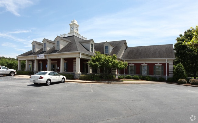
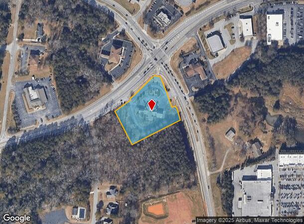
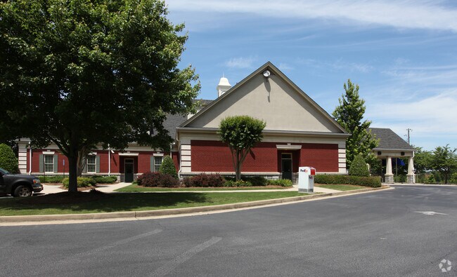
1000 Highway 138 Se
Atlanta-Sandy Springs-Roswell, GA
Commercial
046-0-01-010A
S/SIDE HWY 138
Financialbuilding
Rockdale
X
Georgia
13247C0094D
238
2024
2.25 AC
2025
Lithonia/Conyers
060311
Atlanta
10,900 SF
DEMOGRAPHICS near 1000 Highway 138 Se
1 Mile
3 Mile
5 Mile
2024 Total Population
3,743
37,892
94,416
2029 Population
3,853
39,159
98,802
Pop Growth 2024-2029
+ 2.94%
+ 3.34%
+ 4.65%
Average Age
41
39
39
2024 Total Households
1,414
13,592
33,315
HH Growth 2024-2029
+ 3.04%
+ 3.42%
+ 4.69%
Median Household Inc
$70,218
$65,418
$67,593
Avg Household Size
2.60
2.70
2.80
2024 Avg HH Vehicles
2.00
2.00
2.00
Median Home Value
$241,264
$225,928
$210,387
Median Year Built
1988
1987
1991
Nearby Places
Map Layers
Map Styles
 Street
 Aerial
- Restaurants
- Banks
- Shops
- Fitness
- Groceries
PUBLIC TRANSPORTATION
AIRPORT
Hartsfield - Jackson Atlanta International
DRIVE
WALK
Distance
Hartsfield - Jackson Atlanta International
42 min
30.5 mi
Freight Ports
Georgia Ports - Savannah
DRIVE
WALK
Distance
Georgia Ports - Savannah
275 min
238.4 mi
Nearby Properties
Address
Land Use
TOTAL SIZE
Lot Size
Zoning
Address
Land Use
TOTAL SIZE
Lot Size
Zoning
6,092 SF
37.63 AC
RM
Address
Land Use
TOTAL SIZE
Lot Size
Zoning
4,162 SF
37.52 AC
R3
Address
Land Use
TOTAL SIZE
Lot Size
Zoning
5,212 SF
21.33 AC
GV-UV
Address
Land Use
TOTAL SIZE
Lot Size
Zoning
22,362 SF
28.90 AC
MXD
Address
Land Use
TOTAL SIZE
Lot Size
Zoning
447,440 SF
47.74 AC
ID
Address
Land Use
TOTAL SIZE
Lot Size
Zoning
140,292 SF
23.74 AC
HSB
Address
Land Use
TOTAL SIZE
Lot Size
Zoning
454,480 SF
52.17 AC
ID
Address
Land Use
TOTAL SIZE
Lot Size
Zoning
3,046 SF
33.07 AC
RM
Address
Land Use
TOTAL SIZE
Lot Size
Zoning
165,171 SF
49.79 AC
BG/ID
Address
Land Use
TOTAL SIZE
Lot Size
Zoning
33,216 SF
8.26 AC
MXD/CID/MU
Address
Land Use
TOTAL SIZE
Lot Size
Zoning
8,268 SF
46.94 AC
R3
Address
Land Use
TOTAL SIZE
Lot Size
Zoning
177,123 SF
9.63 AC
MXD/CID/MU
Address
Land Use
TOTAL SIZE
Lot Size
Zoning
131,111 SF
22.17 AC
R3
Address
Land Use
TOTAL SIZE
Lot Size
Zoning
77,600 SF
9 AC
GVUV
Address
Land Use
TOTAL SIZE
Lot Size
Zoning
216,855 SF
42.21 AC
AR
Address
Land Use
TOTAL SIZE
Lot Size
Zoning
205,716 SF
22.88 AC
ID
Address
Land Use
TOTAL SIZE
Lot Size
Zoning
140,850 SF
19.09 AC
ID
Address
Land Use
TOTAL SIZE
Lot Size
Zoning
6,561 SF
7.49 AC
GVUV
Address
Land Use
TOTAL SIZE
Lot Size
Zoning
472,620 SF
55.20 AC
RS10
Address
Land Use
TOTAL SIZE
Lot Size
Zoning
76,140 SF
22.20 AC
RM
Address
Land Use
TOTAL SIZE
Lot Size
Zoning
233,600 SF
69.15 AC
ID
Address
Land Use
TOTAL SIZE
Lot Size
Zoning
94,400 SF
12.50 AC
RS14
Address
Land Use
TOTAL SIZE
Lot Size
Zoning
11,600 SF
4.32 AC
GV/SU
Address
Land Use
TOTAL SIZE
Lot Size
Zoning
78,980 SF
13.64 AC
HSB
Address
Land Use
TOTAL SIZE
Lot Size
Zoning
28,472 SF
42.73 AC
OI
Address
Land Use
TOTAL SIZE
Lot Size
Zoning
174,720 SF
13.54 AC
ID
Address
Land Use
TOTAL SIZE
Lot Size
Zoning
502,000 SF
24.69 AC
M1
Address
Land Use
TOTAL SIZE
Lot Size
Zoning
199,146 SF
22.60 AC
HSB
Address
Land Use
TOTAL SIZE
Lot Size
Zoning
235,000 SF
16.25 AC
M1
Address
Land Use
TOTAL SIZE
Lot Size
Zoning
57,600 SF
10.20 AC
ID
The World's #1 Commercial Real Estate Marketplace
Connect with us
© 2025 CoStar Group
The information above has been obtained from sources believed reliable. While we do not doubt its accuracy we have not verified it and make no guarantee, warranty or representation about it. It is your responsibility to independently confirm its accuracy and completeness. Any projections, opinions, assumptions, or estimates used are for example only and do not represent the current or future performance of the property. The value of this transaction to you depends on tax and other factors which should be evaluated by your tax, financial, and legal advisors. You and your advisors should conduct a careful, independent investigation of the property to determine to your satisfaction the suitability of the property for your needs.