Property Record
1000 Howard Ave, New Orleans, LA 70113
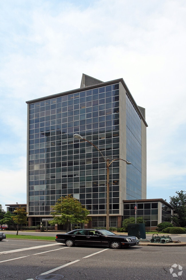

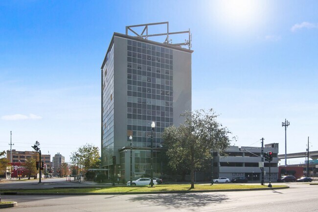

Property Detail
1000 Howard Ave
1-02-1-064-13
SQ 276 UNDESIGNATED LOT 104.3 X 132.7 X 167 X 128 X 53 X 128X 2.7 X 117.11
Commercialnec
Orleans
CBD-1
Louisiana
AE The base floodplain where base flood elevations are provided. AE Zones are now used on new format FIRMs instead of A1-A30 Zones.
vari
2025
0.89 AC
2025
New Orleans CBD
013400
New Orleans/Metairie/Kenner
112,960 SF
New Orleans-Metairie, LA
NEARBY LISTINGS FOR SALE OR LEASE
DEMOGRAPHICS near 1000 Howard Ave
1 mile
3 mile
5 mile
2025 Total Population
23,292
176,122
351,256
2030 Population
23,438
172,416
342,438
Pop Growth 2025-2030
+ 0.63%
(2.10%)
(2.51%)
Average Age
42
41
41
2025 Total Households
13,443
83,683
155,435
HH Growth 2025-2030
+ 0.88%
(2.22%)
(2.65%)
Median Household Inc
$60,479
$62,234
$56,797
Avg Household Size
1.60
1.90
2.10
2025 Avg HH Vehicles
1.00
1.00
1.00
Median Home Value
$445,000
$420,487
$321,662
Median Year Built
1951
1947
1954
Nearby Places
Map Layers
Map Styles
 Street
 Aerial
Layers
 Traffic
 Biking
Places
Listings with unknown addresses are not visible on the map
- Restaurants
- Banks
- Shops
- Fitness
- Groceries
PUBLIC TRANSPORTATION
TRANSIT/SUBWAY
Howard and Carondelet (St. Charles Streetcar - New Orleans Regional Transit Authority Streetcars (New Orleans Streetcars))
Drive
Walk
Distance
Howard and Carondelet (St. Charles Streetcar - New Orleans Regional Transit Authority Streetcars (New Orleans Streetcars))
1 min
6 min
0.3 mi
St Charles at Lee Circle (St. Charles Streetcar - New Orleans Regional Transit Authority Streetcars (New Orleans Streetcars))
Drive
Walk
Distance
St Charles at Lee Circle (St. Charles Streetcar - New Orleans Regional Transit Authority Streetcars (New Orleans Streetcars))
2 min
8 min
0.4 mi
Carondelet and Girod (St. Charles Streetcar - New Orleans Regional Transit Authority Streetcars (New Orleans Streetcars))
Drive
Walk
Distance
Carondelet and Girod (St. Charles Streetcar - New Orleans Regional Transit Authority Streetcars (New Orleans Streetcars))
2 min
9 min
0.4 mi
St Charles and Erato (St. Charles Streetcar - New Orleans Regional Transit Authority Streetcars (New Orleans Streetcars))
Drive
Walk
Distance
St Charles and Erato (St. Charles Streetcar - New Orleans Regional Transit Authority Streetcars (New Orleans Streetcars))
2 min
10 min
0.5 mi
St Charles and MLK Blvd/Melpomene (St. Charles Streetcar - New Orleans Regional Transit Authority Streetcars (New Orleans Streetcars))
Drive
Walk
Distance
St Charles and MLK Blvd/Melpomene (St. Charles Streetcar - New Orleans Regional Transit Authority Streetcars (New Orleans Streetcars))
2 min
12 min
0.6 mi
COMMUTER RAIL
Drive
Walk
Distance
1 min
2 min
0.1 mi
AIRPORT
Louis Armstrong New Orleans International
Drive
Walk
Distance
Louis Armstrong New Orleans International
21 min
14.9 mi
Freight Ports
Port of New Orleans
Drive
Walk
Distance
Port of New Orleans
9 min
2.5 mi
SALE & LEASE HISTORY
LISTING DATE
SALE/LEASE

Feb 16, 2022
For Sale
Nearby Properties
Address
Land Use
TOTAL SIZE
Lot Size
Zoning
Address
Land Use
TOTAL SIZE
Lot Size
Zoning
300 SF
2.19 AC
LS
Address
Land Use
TOTAL SIZE
Lot Size
Zoning
85,052 SF
2.19 AC
LS
Address
Land Use
TOTAL SIZE
Lot Size
Zoning
80.92 AC
EC
Address
Land Use
TOTAL SIZE
Lot Size
Zoning
44.43 AC
CBD-4
Address
Land Use
TOTAL SIZE
Lot Size
Zoning
68.69 AC
CBD-4
Address
Land Use
TOTAL SIZE
Lot Size
Zoning
Address
Land Use
TOTAL SIZE
Lot Size
Zoning
2.02 AC
CBD-7
Address
Land Use
TOTAL SIZE
Lot Size
Zoning
3.66 AC
MC
Address
Land Use
TOTAL SIZE
Lot Size
Zoning
834,043 SF
1.40 AC
CBD-2
Address
Land Use
TOTAL SIZE
Lot Size
Zoning
18.31 AC
CBD-4
Address
Land Use
TOTAL SIZE
Lot Size
Zoning
1.87 AC
CBD-2
Address
Land Use
TOTAL SIZE
Lot Size
Zoning
6.64 AC
Address
Land Use
TOTAL SIZE
Lot Size
Zoning
844,362 SF
5.85 AC
CBD-4
Address
Land Use
TOTAL SIZE
Lot Size
Zoning
0.12 AC
Address
Land Use
TOTAL SIZE
Lot Size
Zoning
30.63 AC
Address
Land Use
TOTAL SIZE
Lot Size
Zoning
444,121 SF
1.46 AC
CBD-1
Address
Land Use
TOTAL SIZE
Lot Size
Zoning
0.88 AC
CBD-2
Address
Land Use
TOTAL SIZE
Lot Size
Zoning
1.91 AC
CBD-1
Address
Land Use
TOTAL SIZE
Lot Size
Zoning
576,962 SF
3.31 AC
CBD-4
Address
Land Use
TOTAL SIZE
Lot Size
Zoning
1.79 AC
Address
Land Use
TOTAL SIZE
Lot Size
Zoning
609,449 SF
1 AC
EC
Address
Land Use
TOTAL SIZE
Lot Size
Zoning
512,729 SF
6.60 AC
Address
Land Use
TOTAL SIZE
Lot Size
Zoning
1.24 AC
CBD-1
Address
Land Use
TOTAL SIZE
Lot Size
Zoning
190,708 SF
1.09 AC
CBD-2
Address
Land Use
TOTAL SIZE
Lot Size
Zoning
499,287 SF
1.44 AC
VCE
Address
Land Use
TOTAL SIZE
Lot Size
Zoning
0.67 AC
CBD-3
Address
Land Use
TOTAL SIZE
Lot Size
Zoning
0.14 AC
HMC-2
Address
Land Use
TOTAL SIZE
Lot Size
Zoning
202,291 SF
4.04 AC
HU-RD2
Address
Land Use
TOTAL SIZE
Lot Size
Zoning
162,382 SF
1.25 AC
CBD-2
Address
Land Use
TOTAL SIZE
Lot Size
Zoning
258,024 SF
0.63 AC
CBD-2
The World's #1 Commercial Real Estate Marketplace
Connect with us
© 2026 CoStar Group
The information above has been obtained from sources believed reliable. While we do not doubt its accuracy we have not verified it and make no guarantee, warranty or representation about it. It is your responsibility to independently confirm its accuracy and completeness. Any projections, opinions, assumptions, or estimates used are for example only and do not represent the current or future performance of the property. The value of this transaction to you depends on tax and other factors which should be evaluated by your tax, financial, and legal advisors. You and your advisors should conduct a careful, independent investigation of the property to determine to your satisfaction the suitability of the property for your needs.