Property Record
1000 Lydias Way, Durham, NC 27713
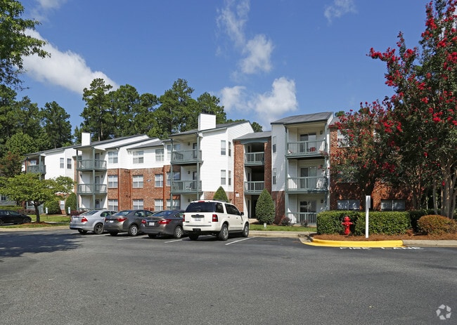

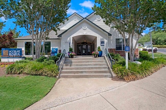
Property Detail
1000 Lydias Way
148153
PROP-WALSJ/WOODCROFT LP/C ROSSLAND SAVINGS FSB DBA PL:000119-000056
Gardenaptcourtapt5plusunits
Durham
PDR 12.000
North Carolina
AE The base floodplain where base flood elevations are provided. AE Zones are now used on new format FIRMs instead of A1-A30 Zones.
20.36 AC
2025
Woodcroft
2025
Raleigh/Durham
002022
Durham-Chapel Hill, NC
12,906 SF
NEARBY LISTINGS FOR SALE OR LEASE
-
-
View all Durham listings for sale on LoopNet.com
DEMOGRAPHICS near 1000 Lydias Way
1 mile
3 mile
5 mile
2025 Total Population
13,325
62,989
142,891
2030 Population
13,946
66,184
151,480
Pop Growth 2025-2030
+ 4.66%
+ 5.07%
+ 6.01%
Average Age
39
39
38
2025 Total Households
6,401
27,651
62,553
HH Growth 2025-2030
+ 4.91%
+ 5.23%
+ 6.23%
Median Household Inc
$104,406
$102,704
$91,742
Avg Household Size
2.00
2.20
2.20
2025 Avg HH Vehicles
2.00
2.00
2.00
Median Home Value
$404,718
$438,408
$455,383
Median Year Built
1995
1995
1996
Nearby Places
Map Layers
Map Styles
 Street
 Aerial
Layers
 Traffic
 Biking
Places
Listings with unknown addresses are not visible on the map
- Restaurants
- Banks
- Shops
- Fitness
- Groceries
PUBLIC TRANSPORTATION
COMMUTER RAIL
Durham Amtrak Station (Carolinian - Amtrak, Piedmont - Amtrak)
Drive
Walk
Distance
Durham Amtrak Station (Carolinian - Amtrak, Piedmont - Amtrak)
15 min
7.4 mi
AIRPORT
Raleigh-Durham International
Drive
Walk
Distance
Raleigh-Durham International
19 min
11.7 mi
Freight Ports
Port of Wilmington
Drive
Walk
Distance
Port of Wilmington
179 min
155.9 mi
Nearby Properties
Address
Land Use
TOTAL SIZE
Lot Size
Zoning
Address
Land Use
TOTAL SIZE
Lot Size
Zoning
778,433 SF
90.38 AC
CC(D)
Address
Land Use
TOTAL SIZE
Lot Size
Zoning
11,568 SF
39.56 AC
RS-M(D)
Address
Land Use
TOTAL SIZE
Lot Size
Zoning
444,254 SF
58.71 AC
SRP
Address
Land Use
TOTAL SIZE
Lot Size
Zoning
35.03 AC
RS-M(D)
Address
Land Use
TOTAL SIZE
Lot Size
Zoning
23,889 SF
50.95 AC
OI
Address
Land Use
TOTAL SIZE
Lot Size
Zoning
7,080 SF
30.67 AC
OI,RS-M
Address
Land Use
TOTAL SIZE
Lot Size
Zoning
6,948 SF
21.22 AC
RS-M(D)
Address
Land Use
TOTAL SIZE
Lot Size
Zoning
10,143 SF
46.78 AC
PDR 5.940
Address
Land Use
TOTAL SIZE
Lot Size
Zoning
7,241 SF
25.34 AC
PDR 5.370
Address
Land Use
TOTAL SIZE
Lot Size
Zoning
8,199 SF
28.28 AC
PDR 12.000
Address
Land Use
TOTAL SIZE
Lot Size
Zoning
555,485 SF
34.84 AC
SRP
Address
Land Use
TOTAL SIZE
Lot Size
Zoning
4,744 SF
12.90 AC
MU(D)
Address
Land Use
TOTAL SIZE
Lot Size
Zoning
9,816 SF
26.57 AC
RS-M
Address
Land Use
TOTAL SIZE
Lot Size
Zoning
9,696 SF
20.94 AC
RS-M(D)
Address
Land Use
TOTAL SIZE
Lot Size
Zoning
13,634 SF
32.31 AC
RS-M
Address
Land Use
TOTAL SIZE
Lot Size
Zoning
12,864 SF
24.27 AC
RS-M
Address
Land Use
TOTAL SIZE
Lot Size
Zoning
240,537 SF
43.98 AC
IL
Address
Land Use
TOTAL SIZE
Lot Size
Zoning
217,507 SF
71.32 AC
CG(D)
Address
Land Use
TOTAL SIZE
Lot Size
Zoning
12,432 SF
26.15 AC
RS-M(D)
Address
Land Use
TOTAL SIZE
Lot Size
Zoning
373,374 SF
109.27 AC
RU-5
Address
Land Use
TOTAL SIZE
Lot Size
Zoning
411,834 SF
29.02 AC
IP(D)
Address
Land Use
TOTAL SIZE
Lot Size
Zoning
11,748 SF
35.02 AC
PDR 8.130
Address
Land Use
TOTAL SIZE
Lot Size
Zoning
1,846 SF
31.05 AC
PDR 3.650
Address
Land Use
TOTAL SIZE
Lot Size
Zoning
105.27 AC
SRP
Address
Land Use
TOTAL SIZE
Lot Size
Zoning
6,000 SF
27.57 AC
RS-M
Address
Land Use
TOTAL SIZE
Lot Size
Zoning
199,294 SF
21.63 AC
MU(D)
Address
Land Use
TOTAL SIZE
Lot Size
Zoning
4,074 SF
33.53 AC
RS-M(D)
Address
Land Use
TOTAL SIZE
Lot Size
Zoning
130,390 SF
7.98 AC
OI(D)
Address
Land Use
TOTAL SIZE
Lot Size
Zoning
214,678 SF
15.87 AC
MU(D)
Address
Land Use
TOTAL SIZE
Lot Size
Zoning
15,908 SF
24.38 AC
RS-M(D)
The World's #1 Commercial Real Estate Marketplace
Connect with us
© 2026 CoStar Group
The information above has been obtained from sources believed reliable. While we do not doubt its accuracy we have not verified it and make no guarantee, warranty or representation about it. It is your responsibility to independently confirm its accuracy and completeness. Any projections, opinions, assumptions, or estimates used are for example only and do not represent the current or future performance of the property. The value of this transaction to you depends on tax and other factors which should be evaluated by your tax, financial, and legal advisors. You and your advisors should conduct a careful, independent investigation of the property to determine to your satisfaction the suitability of the property for your needs.