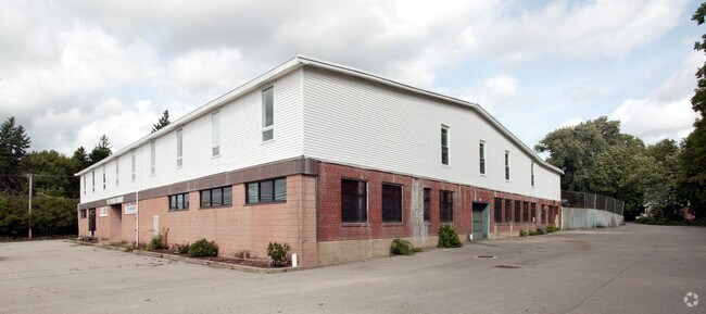
Property Record
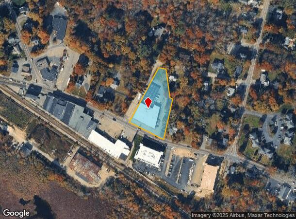
1012 Main St, Hanson, MA 02341
NEARBY LISTINGS FOR SALE OR LEASE
-
-
View all Hanson listings for lease on LoopNet.com
Property Detail
1012 Main St
Storebuilding
Plymouth
X
Massachusetts
25023C0192J
1.40 AC
2025
Route 3 South
2025
Boston
522102
Boston-Cambridge-Newton, MA-NH
37,470 SF
HANS-000042-000000-000056
DEMOGRAPHICS near 1012 Main St
1 Mile
3 Mile
5 Mile
2024 Total Population
1,584
17,375
65,761
2029 Population
1,598
17,391
65,633
Pop Growth 2024-2029
+ 0.88%
+ 0.09%
(0.19%)
Average Age
42
42
42
2024 Total Households
596
6,300
24,003
HH Growth 2024-2029
+ 0.84%
(0.02%)
(0.29%)
Median Household Inc
$88,970
$120,224
$112,366
Avg Household Size
2.70
2.70
2.70
2024 Avg HH Vehicles
2.00
2.00
2.00
Median Home Value
$422,706
$468,127
$458,992
Median Year Built
1970
1970
1972
Nearby Places
Map Layers
Map Styles
 Street
 Aerial
- Restaurants
- Banks
- Shops
- Fitness
- Groceries
PUBLIC TRANSPORTATION
TRANSIT/SUBWAY
Hanson (Kingston/Plymouth Line - Massachusetts Bay Transportation Authority Commuter Rail (Purple Line))
DRIVE
WALK
Distance
Hanson (Kingston/Plymouth Line - Massachusetts Bay Transportation Authority Commuter Rail (Purple Line))
1 min
6 min
0.3 mi
COMMUTER RAIL
Hanson (Kingston/Plymouth Line - Massachusetts Bay Transportation Authority Commuter Rail (Purple Line))
DRIVE
WALK
Distance
Hanson (Kingston/Plymouth Line - Massachusetts Bay Transportation Authority Commuter Rail (Purple Line))
1 min
6 min
0.3 mi
Whitman (Kingston/Plymouth Line - Massachusetts Bay Transportation Authority Commuter Rail (Purple Line))
DRIVE
WALK
Distance
Whitman (Kingston/Plymouth Line - Massachusetts Bay Transportation Authority Commuter Rail (Purple Line))
10 min
4.6 mi
AIRPORT
General Edward Lawrence Logan International
DRIVE
WALK
Distance
General Edward Lawrence Logan International
48 min
30.4 mi
Rhode Island Tf Green International
DRIVE
WALK
Distance
Rhode Island Tf Green International
79 min
44.4 mi
Freight Ports
Port of Boston
DRIVE
WALK
Distance
Port of Boston
46 min
28.2 mi
SALE & LEASE HISTORY
LISTING DATE
SALE/LEASE

Jun 07, 2022
For Lease
Nearby Properties
Address
Land Use
TOTAL SIZE
Lot Size
Zoning
Address
Land Use
TOTAL SIZE
Lot Size
Zoning
69.93 AC
100
Address
Land Use
TOTAL SIZE
Lot Size
Zoning
99,138 SF
83.32 AC
100
Address
Land Use
TOTAL SIZE
Lot Size
Zoning
103,880 SF
30.51 AC
Address
Land Use
TOTAL SIZE
Lot Size
Zoning
64,168 SF
10 AC
100
Address
Land Use
TOTAL SIZE
Lot Size
Zoning
16.12 AC
100
Address
Land Use
TOTAL SIZE
Lot Size
Zoning
78,601 SF
6.83 AC
100
Address
Land Use
TOTAL SIZE
Lot Size
Zoning
36,129 SF
36.70 AC
Address
Land Use
TOTAL SIZE
Lot Size
Zoning
51,280 SF
3.90 AC
100
Address
Land Use
TOTAL SIZE
Lot Size
Zoning
8.20 AC
100
Address
Land Use
TOTAL SIZE
Lot Size
Zoning
38,790 SF
7.82 AC
Address
Land Use
TOTAL SIZE
Lot Size
Zoning
57.50 AC
100
Address
Land Use
TOTAL SIZE
Lot Size
Zoning
1,640 SF
854.31 AC
100
Address
Land Use
TOTAL SIZE
Lot Size
Zoning
14,464 SF
3.94 AC
100
Address
Land Use
TOTAL SIZE
Lot Size
Zoning
54,705 SF
14.77 AC
100
Address
Land Use
TOTAL SIZE
Lot Size
Zoning
56,750 SF
2.85 AC
COMMER
Address
Land Use
TOTAL SIZE
Lot Size
Zoning
32,568 SF
1.89 AC
FLEX O
Address
Land Use
TOTAL SIZE
Lot Size
Zoning
9,000 SF
105.77 AC
Address
Land Use
TOTAL SIZE
Lot Size
Zoning
64,000 SF
3.25 AC
Address
Land Use
TOTAL SIZE
Lot Size
Zoning
34,136 SF
3.45 AC
100
Address
Land Use
TOTAL SIZE
Lot Size
Zoning
22.97 AC
100
Address
Land Use
TOTAL SIZE
Lot Size
Zoning
63.40 AC
100
Address
Land Use
TOTAL SIZE
Lot Size
Zoning
3.44 AC
100
Address
Land Use
TOTAL SIZE
Lot Size
Zoning
13,018 SF
5.91 AC
100
Address
Land Use
TOTAL SIZE
Lot Size
Zoning
12,686 SF
0.66 AC
BUSINE
Address
Land Use
TOTAL SIZE
Lot Size
Zoning
75,519 SF
17.80 AC
100
Address
Land Use
TOTAL SIZE
Lot Size
Zoning
12,272 SF
3.33 AC
100
Address
Land Use
TOTAL SIZE
Lot Size
Zoning
13,535 SF
1.79 AC
100
Address
Land Use
TOTAL SIZE
Lot Size
Zoning
19,592 SF
2.20 AC
CORNER
Address
Land Use
TOTAL SIZE
Lot Size
Zoning
3.35 AC
100
Address
Land Use
TOTAL SIZE
Lot Size
Zoning
10,451 SF
2.98 AC
100
The World's #1 Commercial Real Estate Marketplace
Connect with us
© 2025 CoStar Group
The information above has been obtained from sources believed reliable. While we do not doubt its accuracy we have not verified it and make no guarantee, warranty or representation about it. It is your responsibility to independently confirm its accuracy and completeness. Any projections, opinions, assumptions, or estimates used are for example only and do not represent the current or future performance of the property. The value of this transaction to you depends on tax and other factors which should be evaluated by your tax, financial, and legal advisors. You and your advisors should conduct a careful, independent investigation of the property to determine to your satisfaction the suitability of the property for your needs.