Property Record
1000 N Pine St, Rolla, MO 65401
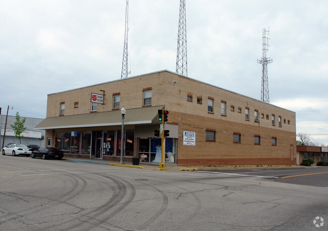

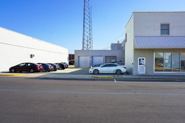
This Property Is For Sale
Property Detail
1000 N Pine St
71-09-1.0-02-004-039-003.000
FRACTIONAL PART BLOCK 89 BISHOP'S THIRD ADDITION SEC 2 TWP 37 N RNG 8 W
Storebuilding
Phelps
B and X Area of moderate flood hazard, usually the area between the limits of the 100-year and 500-year floods.
Missouri
2024
0.30 AC
2025
Missouri South Central Area
890800
Other Market Areas
16,930 SF
Rolla, MO
NEARBY LISTINGS FOR SALE OR LEASE
-
-
View all Rolla listings for sale on LoopNet.com
DEMOGRAPHICS near 1000 N Pine St
1 mile
3 mile
5 mile
2025 Total Population
9,222
23,341
28,111
2030 Population
9,447
23,757
28,644
Pop Growth 2025-2030
+ 2.44%
+ 1.78%
+ 1.90%
Average Age
33
36
37
2025 Total Households
3,411
9,462
11,293
HH Growth 2025-2030
+ 3.05%
+ 1.96%
+ 2.04%
Median Household Inc
$31,246
$45,570
$49,743
Avg Household Size
2.10
2.20
2.20
2025 Avg HH Vehicles
2.00
2.00
2.00
Median Home Value
$139,855
$194,610
$215,552
Median Year Built
1978
1983
1984
Nearby Places
Map Layers
Map Styles
 Street
 Aerial
Layers
 Traffic
 Biking
Places
Listings with unknown addresses are not visible on the map
- Restaurants
- Banks
- Shops
- Fitness
- Groceries
Nearby Properties
Address
Land Use
TOTAL SIZE
Lot Size
Zoning
Address
Land Use
TOTAL SIZE
Lot Size
Zoning
672 SF
9 AC
Address
Land Use
TOTAL SIZE
Lot Size
Zoning
55,554 SF
20.40 AC
Address
Land Use
TOTAL SIZE
Lot Size
Zoning
11,964 SF
8.70 AC
Address
Land Use
TOTAL SIZE
Lot Size
Zoning
173,404 SF
20.30 AC
Address
Land Use
TOTAL SIZE
Lot Size
Zoning
12,050 SF
9.90 AC
Address
Land Use
TOTAL SIZE
Lot Size
Zoning
121,000 SF
20.40 AC
Address
Land Use
TOTAL SIZE
Lot Size
Zoning
129,863 SF
11.80 AC
Address
Land Use
TOTAL SIZE
Lot Size
Zoning
96,905 SF
11.70 AC
Address
Land Use
TOTAL SIZE
Lot Size
Zoning
55,481 SF
8.20 AC
Address
Land Use
TOTAL SIZE
Lot Size
Zoning
4,792 SF
20.90 AC
Address
Land Use
TOTAL SIZE
Lot Size
Zoning
30,776 SF
9.90 AC
Address
Land Use
TOTAL SIZE
Lot Size
Zoning
62,623 SF
7.70 AC
Address
Land Use
TOTAL SIZE
Lot Size
Zoning
68,728 SF
22.90 AC
Address
Land Use
TOTAL SIZE
Lot Size
Zoning
63,810 SF
20.60 AC
Address
Land Use
TOTAL SIZE
Lot Size
Zoning
45,006 SF
2.70 AC
Address
Land Use
TOTAL SIZE
Lot Size
Zoning
45,354 SF
3.40 AC
Address
Land Use
TOTAL SIZE
Lot Size
Zoning
44,919 SF
2.60 AC
Address
Land Use
TOTAL SIZE
Lot Size
Zoning
37,035 SF
1.80 AC
Address
Land Use
TOTAL SIZE
Lot Size
Zoning
105,208 SF
8.70 AC
Address
Land Use
TOTAL SIZE
Lot Size
Zoning
38,550 SF
5.20 AC
Address
Land Use
TOTAL SIZE
Lot Size
Zoning
24,144 SF
2.70 AC
Address
Land Use
TOTAL SIZE
Lot Size
Zoning
4,800 SF
2.10 AC
Address
Land Use
TOTAL SIZE
Lot Size
Zoning
28,604 SF
6.80 AC
Address
Land Use
TOTAL SIZE
Lot Size
Zoning
3,670 SF
5.20 AC
Address
Land Use
TOTAL SIZE
Lot Size
Zoning
38,726 SF
8 AC
Address
Land Use
TOTAL SIZE
Lot Size
Zoning
168,500 SF
6.90 AC
Address
Land Use
TOTAL SIZE
Lot Size
Zoning
33,329 SF
2 AC
Address
Land Use
TOTAL SIZE
Lot Size
Zoning
19,255 SF
2.60 AC
Address
Land Use
TOTAL SIZE
Lot Size
Zoning
12,492 SF
2.90 AC
Address
Land Use
TOTAL SIZE
Lot Size
Zoning
14,607 SF
6.90 AC
The World's #1 Commercial Real Estate Marketplace
Connect with us
© 2026 CoStar Group
The information above has been obtained from sources believed reliable. While we do not doubt its accuracy we have not verified it and make no guarantee, warranty or representation about it. It is your responsibility to independently confirm its accuracy and completeness. Any projections, opinions, assumptions, or estimates used are for example only and do not represent the current or future performance of the property. The value of this transaction to you depends on tax and other factors which should be evaluated by your tax, financial, and legal advisors. You and your advisors should conduct a careful, independent investigation of the property to determine to your satisfaction the suitability of the property for your needs.