Property Record
1000 Pendleton Pky, Neenah, WI 54956
NEARBY LISTINGS FOR SALE OR LEASE
Property Detail
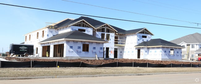
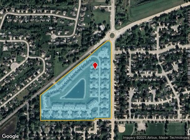
1000 Pendleton Pky
12-0010-0000
Certified Survey Map No 7209
Commercialnec
CSM 7209: PART OF THE SOUTHWEST 1/4 OF THE SOUTHWEST 1/4 SECTI ON 29, PART OF THE SOUTHEAST 1/ 4 OF THE SOUTHEAST 1/4 OF SECTI ON 30 AND PART OF NORTHEAST 1/4 AND NORTHEAST 1/4 ALL LOCATED IN SECTION 31, TOWNSHIP 20 NORT H, RANGE 17 EAST, CITY OF NEE
X
Winnebago
55087C0425D
Wisconsin
2023
2.40 AC
2024
Appleton/Oshkosh
003703
Other Market Areas
12,014 SF
Oshkosh-Neenah, WI
DEMOGRAPHICS near 1000 Pendleton Pky
1 Mile
3 Mile
5 Mile
2024 Total Population
5,026
32,374
56,056
2029 Population
5,000
32,328
55,983
Pop Growth 2024-2029
(0.52%)
(0.14%)
(0.13%)
Average Age
42
40
40
2024 Total Households
2,053
13,538
23,529
HH Growth 2024-2029
(0.63%)
(0.30%)
(0.29%)
Median Household Inc
$77,766
$69,798
$70,000
Avg Household Size
2.40
2.30
2.30
2024 Avg HH Vehicles
2.00
2.00
2.00
Median Home Value
$184,661
$187,201
$188,836
Median Year Built
1978
1972
1972
Nearby Places
Map Layers
Map Styles
 Street
 Aerial
- Restaurants
- Banks
- Shops
- Fitness
- Groceries
PUBLIC TRANSPORTATION
AIRPORT
Appleton International
DRIVE
WALK
Distance
Appleton International
14 min
7.3 mi
Green Bay/Austin Straubel International
DRIVE
WALK
Distance
Green Bay/Austin Straubel International
46 min
37.4 mi
Freight Ports
Port Milwaukee
DRIVE
WALK
Distance
Port Milwaukee
118 min
101.1 mi
Nearby Properties
Address
Land Use
TOTAL SIZE
Lot Size
Zoning
Address
Land Use
TOTAL SIZE
Lot Size
Zoning
156.36 AC
M1
Address
Land Use
TOTAL SIZE
Lot Size
Zoning
800 SF
19.84 AC
I1
Address
Land Use
TOTAL SIZE
Lot Size
Zoning
9.40 AC
Address
Land Use
TOTAL SIZE
Lot Size
Zoning
178,750 SF
0.43 AC
C2
Address
Land Use
TOTAL SIZE
Lot Size
Zoning
59,584 SF
12.11 AC
C1
Address
Land Use
TOTAL SIZE
Lot Size
Zoning
103,427 SF
0.56 AC
PDD
Address
Land Use
TOTAL SIZE
Lot Size
Zoning
6.75 AC
M1
Address
Land Use
TOTAL SIZE
Lot Size
Zoning
89,042 SF
2.83 AC
C2
Address
Land Use
TOTAL SIZE
Lot Size
Zoning
32.54 AC
Address
Land Use
TOTAL SIZE
Lot Size
Zoning
89,576 SF
1.03 AC
C2
Address
Land Use
TOTAL SIZE
Lot Size
Zoning
105,852 SF
0.39 AC
PDD
Address
Land Use
TOTAL SIZE
Lot Size
Zoning
67.41 AC
I2
Address
Land Use
TOTAL SIZE
Lot Size
Zoning
29.32 AC
I1
Address
Land Use
TOTAL SIZE
Lot Size
Zoning
210,214 SF
16.44 AC
I1
Address
Land Use
TOTAL SIZE
Lot Size
Zoning
86,455 SF
PDD
Address
Land Use
TOTAL SIZE
Lot Size
Zoning
361,899 SF
18.54 AC
I2
Address
Land Use
TOTAL SIZE
Lot Size
Zoning
74,603 SF
4.96 AC
I1
Address
Land Use
TOTAL SIZE
Lot Size
Zoning
92,030 SF
7.79 AC
I1
Address
Land Use
TOTAL SIZE
Lot Size
Zoning
145,322 SF
11.20 AC
PDD
Address
Land Use
TOTAL SIZE
Lot Size
Zoning
10.13 AC
M2
Address
Land Use
TOTAL SIZE
Lot Size
Zoning
92,039 SF
13.55 AC
I2
Address
Land Use
TOTAL SIZE
Lot Size
Zoning
11.77 AC
R5
Address
Land Use
TOTAL SIZE
Lot Size
Zoning
32.60 AC
Address
Land Use
TOTAL SIZE
Lot Size
Zoning
31,400 SF
0.37 AC
PDD
Address
Land Use
TOTAL SIZE
Lot Size
Zoning
9.27 AC
I1
Address
Land Use
TOTAL SIZE
Lot Size
Zoning
48,933 SF
2.80 AC
PDD
Address
Land Use
TOTAL SIZE
Lot Size
Zoning
4.71 AC
Address
Land Use
TOTAL SIZE
Lot Size
Zoning
22.72 AC
I1
Address
Land Use
TOTAL SIZE
Lot Size
Zoning
80,914 SF
1.30 AC
C2
The World's #1 Commercial Real Estate Marketplace
Connect with us
© 2026 CoStar Group
The information above has been obtained from sources believed reliable. While we do not doubt its accuracy we have not verified it and make no guarantee, warranty or representation about it. It is your responsibility to independently confirm its accuracy and completeness. Any projections, opinions, assumptions, or estimates used are for example only and do not represent the current or future performance of the property. The value of this transaction to you depends on tax and other factors which should be evaluated by your tax, financial, and legal advisors. You and your advisors should conduct a careful, independent investigation of the property to determine to your satisfaction the suitability of the property for your needs.