Property Record
1000 Pine Top Rd, Belton, SC 29627

Property Detail
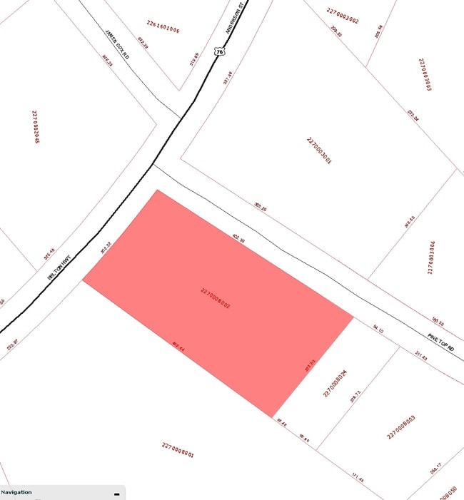
1000 Pine Top Rd
227-00-08-002
CP 080/117 F000 D000 PINE TOP RD 1.94 AC
Officebuilding
Anderson
B and X Area of moderate flood hazard, usually the area between the limits of the 100-year and 500-year floods.
South Carolina
2025
1.94 AC
2025
Anderson County
011302
Greenville/Spartanburg
4,717 SF
Greenville-Anderson-Greer, SC
NEARBY LISTINGS FOR SALE OR LEASE
-
-
View all Belton listings for sale on LoopNet.com
DEMOGRAPHICS near 1000 Pine Top Rd
1 mile
3 mile
5 mile
2025 Total Population
920
8,925
19,690
2030 Population
977
9,429
20,740
Pop Growth 2025-2030
+ 6.20%
+ 5.65%
+ 5.33%
Average Age
42
42
42
2025 Total Households
370
3,603
7,759
HH Growth 2025-2030
+ 6.49%
+ 5.86%
+ 5.49%
Median Household Inc
$70,914
$61,904
$61,429
Avg Household Size
2.50
2.40
2.50
2025 Avg HH Vehicles
2.00
2.00
2.00
Median Home Value
$170,678
$172,067
$175,967
Median Year Built
1987
1973
1978
Nearby Places
Map Layers
Map Styles
 Street
 Aerial
Layers
 Traffic
 Biking
Places
Listings with unknown addresses are not visible on the map
- Restaurants
- Banks
- Shops
- Fitness
- Groceries
PUBLIC TRANSPORTATION
AIRPORT
Greenville Spartanburg International
Drive
Walk
Distance
Greenville Spartanburg International
55 min
39.9 mi
Nearby Properties
Address
Land Use
TOTAL SIZE
Lot Size
Zoning
Address
Land Use
TOTAL SIZE
Lot Size
Zoning
230,048 SF
16.62 AC
Address
Land Use
TOTAL SIZE
Lot Size
Zoning
53,387 SF
2.57 AC
Address
Land Use
TOTAL SIZE
Lot Size
Zoning
696 SF
4.57 AC
Address
Land Use
TOTAL SIZE
Lot Size
Zoning
8,425 SF
1.37 AC
Address
Land Use
TOTAL SIZE
Lot Size
Zoning
59,545 SF
15.42 AC
Address
Land Use
TOTAL SIZE
Lot Size
Zoning
12,276 SF
1.97 AC
Address
Land Use
TOTAL SIZE
Lot Size
Zoning
158,791 SF
54.55 AC
Address
Land Use
TOTAL SIZE
Lot Size
Zoning
2,070 SF
2.50 AC
Address
Land Use
TOTAL SIZE
Lot Size
Zoning
2,905 SF
1.13 AC
Address
Land Use
TOTAL SIZE
Lot Size
Zoning
2,347 SF
1.38 AC
Address
Land Use
TOTAL SIZE
Lot Size
Zoning
59.40 AC
Address
Land Use
TOTAL SIZE
Lot Size
Zoning
50,849 SF
7.07 AC
Address
Land Use
TOTAL SIZE
Lot Size
Zoning
2,482 SF
5.93 AC
Address
Land Use
TOTAL SIZE
Lot Size
Zoning
2,619 SF
1.03 AC
Address
Land Use
TOTAL SIZE
Lot Size
Zoning
3,421 SF
1.18 AC
Address
Land Use
TOTAL SIZE
Lot Size
Zoning
42,248 SF
2.22 AC
Address
Land Use
TOTAL SIZE
Lot Size
Zoning
2,774 SF
2.12 AC
Address
Land Use
TOTAL SIZE
Lot Size
Zoning
2,877 SF
1.17 AC
Address
Land Use
TOTAL SIZE
Lot Size
Zoning
14,970 SF
3.86 AC
Address
Land Use
TOTAL SIZE
Lot Size
Zoning
9,760 SF
2.92 AC
Address
Land Use
TOTAL SIZE
Lot Size
Zoning
54,666 SF
10.40 AC
Address
Land Use
TOTAL SIZE
Lot Size
Zoning
4,229 SF
6.17 AC
Address
Land Use
TOTAL SIZE
Lot Size
Zoning
7,000 SF
0.66 AC
Address
Land Use
TOTAL SIZE
Lot Size
Zoning
4,784 SF
0.78 AC
Address
Land Use
TOTAL SIZE
Lot Size
Zoning
6,190 SF
10.04 AC
Address
Land Use
TOTAL SIZE
Lot Size
Zoning
3,190 SF
0.95 AC
Address
Land Use
TOTAL SIZE
Lot Size
Zoning
2,693 SF
3.11 AC
Address
Land Use
TOTAL SIZE
Lot Size
Zoning
54,269 SF
10.76 AC
Address
Land Use
TOTAL SIZE
Lot Size
Zoning
12,000 SF
2.86 AC
The World's #1 Commercial Real Estate Marketplace
Connect with us
© 2026 CoStar Group
The information above has been obtained from sources believed reliable. While we do not doubt its accuracy we have not verified it and make no guarantee, warranty or representation about it. It is your responsibility to independently confirm its accuracy and completeness. Any projections, opinions, assumptions, or estimates used are for example only and do not represent the current or future performance of the property. The value of this transaction to you depends on tax and other factors which should be evaluated by your tax, financial, and legal advisors. You and your advisors should conduct a careful, independent investigation of the property to determine to your satisfaction the suitability of the property for your needs.