Property Record
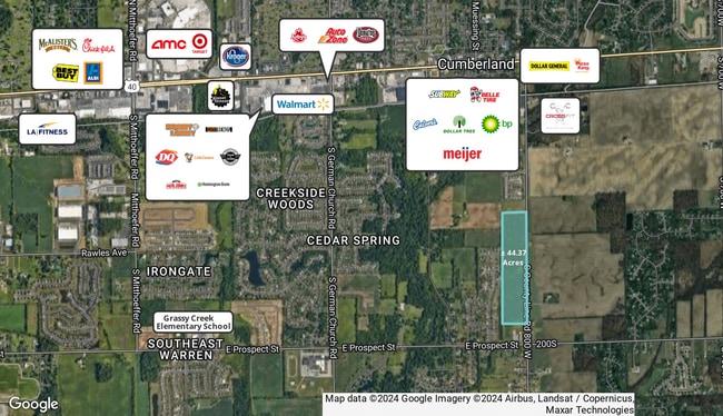
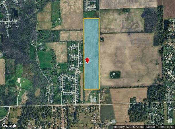
1000 S Carroll Rd, Indianapolis, IN 46239
This Property Is For Sale
NEARBY LISTINGS FOR SALE OR LEASE
Property Detail
1000 S Carroll Rd
49-09-10-110-001.000-700
PT SE1/4 & PT NE1/4 S10 T15N R5E COMM SE COR SE1/4 N660.00 TO P.O.B. W661.02 N2916.90 E664.21 S2916.01 TO BEG 44.373 AC. (43.225 AC. TAXABLE)
Agriculturalland
Marion
X
Indiana
18097C0190F
44.37 AC
2023
Lawrence/East County
2024
Indianapolis
390200
Indianapolis-Carmel-Anderson, IN
DEMOGRAPHICS near 1000 S Carroll Rd
1 Mile
3 Mile
5 Mile
2024 Total Population
2,320
32,405
97,586
2029 Population
2,356
33,030
98,562
Pop Growth 2024-2029
+ 1.55%
+ 1.93%
+ 1.00%
Average Age
41
40
37
2024 Total Households
866
12,021
36,271
HH Growth 2024-2029
+ 1.73%
+ 2.05%
+ 1.08%
Median Household Inc
$97,485
$84,380
$68,419
Avg Household Size
2.60
2.60
2.60
2024 Avg HH Vehicles
2.00
2.00
2.00
Median Home Value
$188,049
$206,556
$189,706
Median Year Built
1995
1991
1982
Nearby Places
- Restaurants
- Banks
- Shops
- Fitness
- Groceries
PUBLIC TRANSPORTATION
AIRPORT
Indianapolis International
DRIVE
WALK
Distance
Indianapolis International
45 min
24.6 mi
Freight Ports
Port of Toledo
DRIVE
WALK
Distance
Port of Toledo
272 min
220.5 mi
Nearby Properties
Address
Land Use
TOTAL SIZE
Lot Size
Zoning
Address
Land Use
TOTAL SIZE
Lot Size
Zoning
4,379 SF
11.48 AC
ZO01
Address
Land Use
TOTAL SIZE
Lot Size
Zoning
213,102 SF
14.51 AC
Address
Land Use
TOTAL SIZE
Lot Size
Zoning
234,064 SF
29.49 AC
ZO01
Address
Land Use
TOTAL SIZE
Lot Size
Zoning
2,730 SF
21.24 AC
Address
Land Use
TOTAL SIZE
Lot Size
Zoning
5,560 SF
10.88 AC
ZO01
Address
Land Use
TOTAL SIZE
Lot Size
Zoning
170,000 SF
11.29 AC
ZO01
Address
Land Use
TOTAL SIZE
Lot Size
Zoning
169,094 SF
10.43 AC
ZO01
Address
Land Use
TOTAL SIZE
Lot Size
Zoning
140,976 SF
15.46 AC
ZO01
Address
Land Use
TOTAL SIZE
Lot Size
Zoning
51,390 SF
40.43 AC
Address
Land Use
TOTAL SIZE
Lot Size
Zoning
48,838 SF
15.09 AC
Address
Land Use
TOTAL SIZE
Lot Size
Zoning
113,863 SF
13.60 AC
Address
Land Use
TOTAL SIZE
Lot Size
Zoning
107,656 SF
7.66 AC
Address
Land Use
TOTAL SIZE
Lot Size
Zoning
160,410 SF
13.71 AC
Address
Land Use
TOTAL SIZE
Lot Size
Zoning
12,786 SF
24.78 AC
ZO01
Address
Land Use
TOTAL SIZE
Lot Size
Zoning
121,697 SF
10.05 AC
ZO01
Address
Land Use
TOTAL SIZE
Lot Size
Zoning
2,784 SF
23 AC
ZO01
Address
Land Use
TOTAL SIZE
Lot Size
Zoning
5,287 SF
16.61 AC
ZO01
Address
Land Use
TOTAL SIZE
Lot Size
Zoning
37,364 SF
10 AC
ZO01
Address
Land Use
TOTAL SIZE
Lot Size
Zoning
54,354 SF
5.11 AC
ZO01
Address
Land Use
TOTAL SIZE
Lot Size
Zoning
86,932 SF
9.99 AC
Address
Land Use
TOTAL SIZE
Lot Size
Zoning
78,500 SF
7.63 AC
ZO01
Address
Land Use
TOTAL SIZE
Lot Size
Zoning
82,702 SF
7.34 AC
ZO01
Address
Land Use
TOTAL SIZE
Lot Size
Zoning
69,620 SF
7.16 AC
ZO01
Address
Land Use
TOTAL SIZE
Lot Size
Zoning
3,507 SF
28.32 AC
Address
Land Use
TOTAL SIZE
Lot Size
Zoning
18,154 SF
1.36 AC
ZO01
Address
Land Use
TOTAL SIZE
Lot Size
Zoning
103,032 SF
10.60 AC
Address
Land Use
TOTAL SIZE
Lot Size
Zoning
41,992 SF
4 AC
ZO01
Address
Land Use
TOTAL SIZE
Lot Size
Zoning
16,282 SF
10.23 AC
Address
Land Use
TOTAL SIZE
Lot Size
Zoning
32,000 SF
5.67 AC
ZO01
Address
Land Use
TOTAL SIZE
Lot Size
Zoning
47,427 SF
3.04 AC
ZO01
The World's #1 Commercial Real Estate Marketplace
Connect with us
© 2025 CoStar Group
The information above has been obtained from sources believed reliable. While we do not doubt its accuracy we have not verified it and make no guarantee, warranty or representation about it. It is your responsibility to independently confirm its accuracy and completeness. Any projections, opinions, assumptions, or estimates used are for example only and do not represent the current or future performance of the property. The value of this transaction to you depends on tax and other factors which should be evaluated by your tax, financial, and legal advisors. You and your advisors should conduct a careful, independent investigation of the property to determine to your satisfaction the suitability of the property for your needs.