Property Record
1000 Whitlock Ave Nw, Marietta, GA 30064

NEARBY LISTINGS FOR SALE OR LEASE
Property Detail
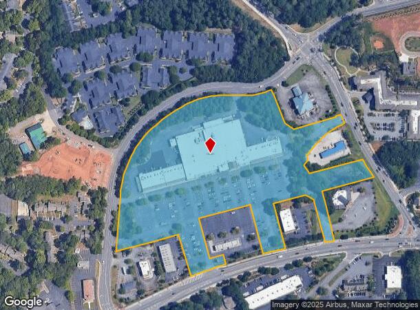
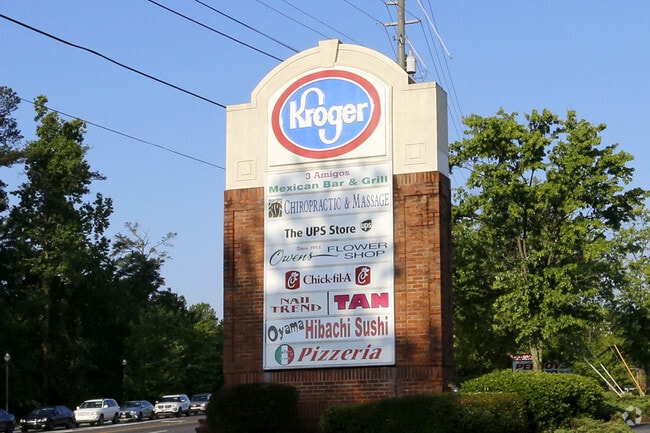
1000 Whitlock Ave Nw
20-0323-0-003-0
Hayley-Redd Lllp
Regionalshoppingcenterormallwithanchorstore
Cobb
X
Georgia
13067C0104H
9.45 AC
2025
Kennesaw/NW Cobb
2025
Atlanta
030602
Atlanta-Sandy Springs-Roswell, GA
93,128 SF
DEMOGRAPHICS near 1000 Whitlock Ave Nw
1 Mile
3 Mile
5 Mile
2024 Total Population
6,580
59,511
179,459
2029 Population
6,670
60,885
183,467
Pop Growth 2024-2029
+ 1.37%
+ 2.31%
+ 2.23%
Average Age
43
40
38
2024 Total Households
2,740
23,440
67,646
HH Growth 2024-2029
+ 1.35%
+ 2.32%
+ 2.30%
Median Household Inc
$119,146
$84,984
$75,474
Avg Household Size
2.30
2.40
2.50
2024 Avg HH Vehicles
2.00
2.00
2.00
Median Home Value
$395,680
$385,316
$335,206
Median Year Built
1985
1988
1988
Nearby Places
Map Layers
Map Styles
 Street
 Aerial
- Restaurants
- Banks
- Shops
- Fitness
- Groceries
PUBLIC TRANSPORTATION
AIRPORT
Hartsfield - Jackson Atlanta International
DRIVE
WALK
Distance
Hartsfield - Jackson Atlanta International
45 min
30.7 mi
SALE & LEASE HISTORY
LISTING DATE
SALE/LEASE

Sep 24, 2016
For Lease
Jun 06, 2019
For Lease
Jan 04, 2017
For Lease
Nearby Properties
Address
Land Use
TOTAL SIZE
Lot Size
Zoning
Address
Land Use
TOTAL SIZE
Lot Size
Zoning
379,750 SF
11.14 AC
Address
Land Use
TOTAL SIZE
Lot Size
Zoning
507,196 SF
67.83 AC
RM-12
Address
Land Use
TOTAL SIZE
Lot Size
Zoning
283,134 SF
13.10 AC
PVC
Address
Land Use
TOTAL SIZE
Lot Size
Zoning
129,168 SF
0.82 AC
OI
Address
Land Use
TOTAL SIZE
Lot Size
Zoning
284,213 SF
19.85 AC
RM-12
Address
Land Use
TOTAL SIZE
Lot Size
Zoning
225,315 SF
17.10 AC
RM-12
Address
Land Use
TOTAL SIZE
Lot Size
Zoning
236,808 SF
29.38 AC
PRD MF
Address
Land Use
TOTAL SIZE
Lot Size
Zoning
222,906 SF
18.96 AC
RM-12
Address
Land Use
TOTAL SIZE
Lot Size
Zoning
225,728 SF
8.11 AC
PVC
Address
Land Use
TOTAL SIZE
Lot Size
Zoning
176,350 SF
19.56 AC
PRD MF
Address
Land Use
TOTAL SIZE
Lot Size
Zoning
143,362 SF
1.61 AC
OI
Address
Land Use
TOTAL SIZE
Lot Size
Zoning
82,012 SF
9.53 AC
Address
Land Use
TOTAL SIZE
Lot Size
Zoning
213,318 SF
19.28 AC
PRD MF
Address
Land Use
TOTAL SIZE
Lot Size
Zoning
13.17 AC
LI
Address
Land Use
TOTAL SIZE
Lot Size
Zoning
180,508 SF
21.88 AC
RM-8
Address
Land Use
TOTAL SIZE
Lot Size
Zoning
147,029 SF
3.05 AC
PRD MF
Address
Land Use
TOTAL SIZE
Lot Size
Zoning
217,980 SF
12.61 AC
PRD MF
Address
Land Use
TOTAL SIZE
Lot Size
Zoning
188,789 SF
8.88 AC
PRD MF
Address
Land Use
TOTAL SIZE
Lot Size
Zoning
Address
Land Use
TOTAL SIZE
Lot Size
Zoning
1,093 SF
3.73 AC
RM-8/SLO
Address
Land Use
TOTAL SIZE
Lot Size
Zoning
276,095 SF
13.77 AC
HI
Address
Land Use
TOTAL SIZE
Lot Size
Zoning
133,813 SF
10 AC
RM-12
Address
Land Use
TOTAL SIZE
Lot Size
Zoning
127,776 SF
10.37 AC
RM-12
Address
Land Use
TOTAL SIZE
Lot Size
Zoning
77,699 SF
3.84 AC
O&I/WS
Address
Land Use
TOTAL SIZE
Lot Size
Zoning
72,572 SF
0.53 AC
OI
Address
Land Use
TOTAL SIZE
Lot Size
Zoning
97,836 SF
8.88 AC
NRC/CRC
Address
Land Use
TOTAL SIZE
Lot Size
Zoning
53.78 AC
R20
Address
Land Use
TOTAL SIZE
Lot Size
Zoning
157,524 SF
1.97 AC
OI
Address
Land Use
TOTAL SIZE
Lot Size
Zoning
61,455 SF
0.50 AC
OI
Address
Land Use
TOTAL SIZE
Lot Size
Zoning
316,952 SF
3.23 AC
O&I
The World's #1 Commercial Real Estate Marketplace
Connect with us
© 2025 CoStar Group
The information above has been obtained from sources believed reliable. While we do not doubt its accuracy we have not verified it and make no guarantee, warranty or representation about it. It is your responsibility to independently confirm its accuracy and completeness. Any projections, opinions, assumptions, or estimates used are for example only and do not represent the current or future performance of the property. The value of this transaction to you depends on tax and other factors which should be evaluated by your tax, financial, and legal advisors. You and your advisors should conduct a careful, independent investigation of the property to determine to your satisfaction the suitability of the property for your needs.