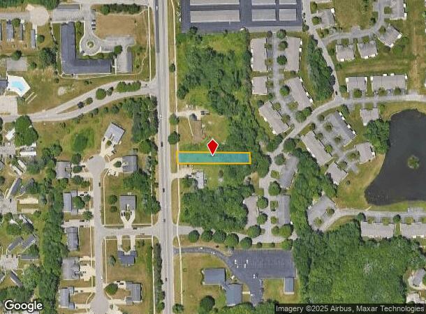
Property Record
1000 Wilson Ave Nw, Grand Rapids, MI 49534
NEARBY LISTINGS FOR SALE OR LEASE
Property Detail
1000 Wilson Ave Nw
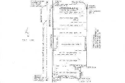
41-13-19-201-036
PART NE 1/4 COM 1340 FT N FROM CEN OF SEC TH S 88D 10M E 350 FT TH NLY PAR WITH CL OF WILSON AVE TO A LINE BEARING S 88D 10M
Commercialacreage
Kent
X
Michigan
26081C0382D
0.37 AC
2024
W Grand Rapids/Walker
2025
West Michigan
011701
Grand Rapids-Wyoming, MI
DEMOGRAPHICS near 1000 Wilson Ave Nw
1 Mile
3 Mile
5 Mile
2024 Total Population
6,607
32,689
81,311
2029 Population
6,720
33,446
82,351
Pop Growth 2024-2029
+ 1.71%
+ 2.32%
+ 1.28%
Average Age
39
41
38
2024 Total Households
2,603
13,477
32,566
HH Growth 2024-2029
+ 1.58%
+ 2.16%
+ 1.28%
Median Household Inc
$72,699
$75,290
$69,331
Avg Household Size
2.50
2.40
2.40
2024 Avg HH Vehicles
2.00
2.00
2.00
Median Home Value
$238,516
$250,772
$230,334
Median Year Built
1986
1983
1969
Nearby Places
Map Layers
Map Styles
 Street
 Aerial
- Restaurants
- Banks
- Shops
- Fitness
- Groceries
PUBLIC TRANSPORTATION
COMMUTER RAIL
DRIVE
WALK
Distance
13 min
6.8 mi
AIRPORT
Gerald R Ford International
DRIVE
WALK
Distance
Gerald R Ford International
32 min
21.0 mi
Nearby Properties
Address
Land Use
TOTAL SIZE
Lot Size
Zoning
Address
Land Use
TOTAL SIZE
Lot Size
Zoning
390,682 SF
47.73 AC
ARM - MULT
Address
Land Use
TOTAL SIZE
Lot Size
Zoning
389,181 SF
51.01 AC
RPUD - 2
Address
Land Use
TOTAL SIZE
Lot Size
Zoning
32.89 AC
TN-LDR
Address
Land Use
TOTAL SIZE
Lot Size
Zoning
340,744 SF
69.50 AC
RPUD - 2
Address
Land Use
TOTAL SIZE
Lot Size
Zoning
343,973 SF
29.15 AC
MON-LDR
Address
Land Use
TOTAL SIZE
Lot Size
Zoning
278,832 SF
NOT APP
Address
Land Use
TOTAL SIZE
Lot Size
Zoning
245,620 SF
20.13 AC
RPUD - 2
Address
Land Use
TOTAL SIZE
Lot Size
Zoning
410,206 SF
54.36 AC
MH
Address
Land Use
TOTAL SIZE
Lot Size
Zoning
162,765 SF
22.63 AC
MP
Address
Land Use
TOTAL SIZE
Lot Size
Zoning
209,522 SF
27.89 AC
CPUD
Address
Land Use
TOTAL SIZE
Lot Size
Zoning
147,232 SF
18.42 AC
ARM - MULT
Address
Land Use
TOTAL SIZE
Lot Size
Zoning
247,168 SF
9.60 AC
MP
Address
Land Use
TOTAL SIZE
Lot Size
Zoning
332,315 SF
17.71 AC
MP
Address
Land Use
TOTAL SIZE
Lot Size
Zoning
107,800 SF
13.29 AC
CPUD
Address
Land Use
TOTAL SIZE
Lot Size
Zoning
250,469 SF
14.11 AC
ML
Address
Land Use
TOTAL SIZE
Lot Size
Zoning
200,831 SF
11.69 AC
MH
Address
Land Use
TOTAL SIZE
Lot Size
Zoning
140,841 SF
8.96 AC
Address
Land Use
TOTAL SIZE
Lot Size
Zoning
197,220 SF
10.94 AC
MP
Address
Land Use
TOTAL SIZE
Lot Size
Zoning
222,833 SF
20.49 AC
MH
Address
Land Use
TOTAL SIZE
Lot Size
Zoning
85,472 SF
12.17 AC
ARM - MULT
Address
Land Use
TOTAL SIZE
Lot Size
Zoning
104,000 SF
NOT APP
Address
Land Use
TOTAL SIZE
Lot Size
Zoning
Address
Land Use
TOTAL SIZE
Lot Size
Zoning
141,672 SF
11.82 AC
MP
Address
Land Use
TOTAL SIZE
Lot Size
Zoning
78,872 SF
3.09 AC
MON-LDR
Address
Land Use
TOTAL SIZE
Lot Size
Zoning
200,000 SF
13.41 AC
MP
Address
Land Use
TOTAL SIZE
Lot Size
Zoning
65,491 SF
7.29 AC
MP
Address
Land Use
TOTAL SIZE
Lot Size
Zoning
195,000 SF
11.09 AC
MP
Address
Land Use
TOTAL SIZE
Lot Size
Zoning
88,113 SF
12.50 AC
Address
Land Use
TOTAL SIZE
Lot Size
Zoning
104,399 SF
16.83 AC
ML
Address
Land Use
TOTAL SIZE
Lot Size
Zoning
162,020 SF
20 AC
MH
The World's #1 Commercial Real Estate Marketplace
Connect with us
© 2025 CoStar Group
The information above has been obtained from sources believed reliable. While we do not doubt its accuracy we have not verified it and make no guarantee, warranty or representation about it. It is your responsibility to independently confirm its accuracy and completeness. Any projections, opinions, assumptions, or estimates used are for example only and do not represent the current or future performance of the property. The value of this transaction to you depends on tax and other factors which should be evaluated by your tax, financial, and legal advisors. You and your advisors should conduct a careful, independent investigation of the property to determine to your satisfaction the suitability of the property for your needs.