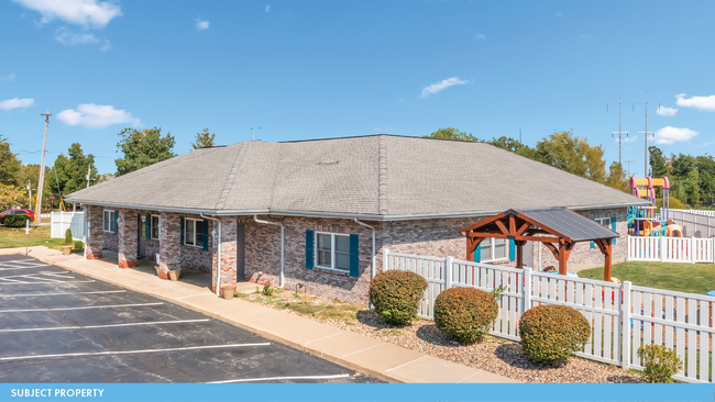
Property Record
1000 Wyndgate Ridge Dr, Lake Saint Louis, MO 63367


NEARBY LISTINGS FOR SALE OR LEASE
Property Detail
1000 Wyndgate Ridge Dr
St. Louis, MO-IL
Wyndgate Vlg #1
4-0066-9972-OL-000A.0000000
WYNDGATE VLG B #1 LOT OUTLOT A
Commercialnec
St. Charles
X
Missouri
29183C0220G
a
2024
1.40 AC
2025
St Charles County
312209
St. Louis
7,634 SF
DEMOGRAPHICS near 1000 Wyndgate Ridge Dr
1 Mile
3 Mile
5 Mile
2024 Total Population
7,753
40,727
95,075
2029 Population
8,346
43,623
101,430
Pop Growth 2024-2029
+ 7.65%
+ 7.11%
+ 6.68%
Average Age
35
38
39
2024 Total Households
2,500
14,517
34,228
HH Growth 2024-2029
+ 7.72%
+ 7.20%
+ 6.74%
Median Household Inc
$134,110
$112,891
$108,126
Avg Household Size
3.10
2.80
2.70
2024 Avg HH Vehicles
2.00
2.00
2.00
Median Home Value
$379,023
$342,130
$328,021
Median Year Built
2010
2006
2003
Nearby Places
Map Layers
Map Styles
 Street
 Aerial
- Restaurants
- Banks
- Shops
- Fitness
- Groceries
PUBLIC TRANSPORTATION
AIRPORT
St Louis Lambert International
DRIVE
WALK
Distance
St Louis Lambert International
41 min
29.4 mi
Freight Ports
Tulsa Port of Inola
DRIVE
WALK
Distance
Tulsa Port of Inola
421 min
370.8 mi
SALE & LEASE HISTORY
LISTING DATE
SALE/LEASE

Nov 02, 2023
For Sale
Nearby Properties
Address
Land Use
TOTAL SIZE
Lot Size
Zoning
Address
Land Use
TOTAL SIZE
Lot Size
Zoning
482.60 AC
AC7
Address
Land Use
TOTAL SIZE
Lot Size
Zoning
67,680 SF
7.08 AC
Address
Land Use
TOTAL SIZE
Lot Size
Zoning
420,705 SF
37.21 AC
Address
Land Use
TOTAL SIZE
Lot Size
Zoning
244,087 SF
7.24 AC
Address
Land Use
TOTAL SIZE
Lot Size
Zoning
479,232 SF
36.53 AC
AA7
Address
Land Use
TOTAL SIZE
Lot Size
Zoning
44,952 SF
19.67 AC
Address
Land Use
TOTAL SIZE
Lot Size
Zoning
Address
Land Use
TOTAL SIZE
Lot Size
Zoning
200,008 SF
14.30 AC
Address
Land Use
TOTAL SIZE
Lot Size
Zoning
36,607 SF
6.10 AC
AF0
Address
Land Use
TOTAL SIZE
Lot Size
Zoning
77.65 AC
AC7
Address
Land Use
TOTAL SIZE
Lot Size
Zoning
161,427 SF
8.80 AC
Address
Land Use
TOTAL SIZE
Lot Size
Zoning
7,793 SF
26.43 AC
Address
Land Use
TOTAL SIZE
Lot Size
Zoning
140,826 SF
7.09 AC
Address
Land Use
TOTAL SIZE
Lot Size
Zoning
66,782 SF
6.72 AC
Address
Land Use
TOTAL SIZE
Lot Size
Zoning
218,526 SF
21.26 AC
Address
Land Use
TOTAL SIZE
Lot Size
Zoning
183,416 SF
40.46 AC
Address
Land Use
TOTAL SIZE
Lot Size
Zoning
375,136 SF
34.40 AC
Address
Land Use
TOTAL SIZE
Lot Size
Zoning
144,151 SF
4.36 AC
Address
Land Use
TOTAL SIZE
Lot Size
Zoning
108.37 AC
Address
Land Use
TOTAL SIZE
Lot Size
Zoning
101,305 SF
11.11 AC
Address
Land Use
TOTAL SIZE
Lot Size
Zoning
5,205 SF
161.53 AC
AA1
Address
Land Use
TOTAL SIZE
Lot Size
Zoning
121,518 SF
3.40 AC
Address
Land Use
TOTAL SIZE
Lot Size
Zoning
137,814 SF
15.08 AC
Address
Land Use
TOTAL SIZE
Lot Size
Zoning
127,764 SF
9.67 AC
Address
Land Use
TOTAL SIZE
Lot Size
Zoning
10,690 SF
11.23 AC
AA2
Address
Land Use
TOTAL SIZE
Lot Size
Zoning
106,447 SF
6.53 AC
Address
Land Use
TOTAL SIZE
Lot Size
Zoning
25.36 AC
Address
Land Use
TOTAL SIZE
Lot Size
Zoning
84,327 SF
4.36 AC
Address
Land Use
TOTAL SIZE
Lot Size
Zoning
76,849 SF
14.24 AC
Address
Land Use
TOTAL SIZE
Lot Size
Zoning
127.98 AC
AA1
The World's #1 Commercial Real Estate Marketplace
Connect with us
© 2026 CoStar Group
The information above has been obtained from sources believed reliable. While we do not doubt its accuracy we have not verified it and make no guarantee, warranty or representation about it. It is your responsibility to independently confirm its accuracy and completeness. Any projections, opinions, assumptions, or estimates used are for example only and do not represent the current or future performance of the property. The value of this transaction to you depends on tax and other factors which should be evaluated by your tax, financial, and legal advisors. You and your advisors should conduct a careful, independent investigation of the property to determine to your satisfaction the suitability of the property for your needs.