Property Record
10201 Pringle Ave, Galt, CA 95632
This Property Is For Sale
NEARBY LISTINGS FOR SALE OR LEASE
Property Detail
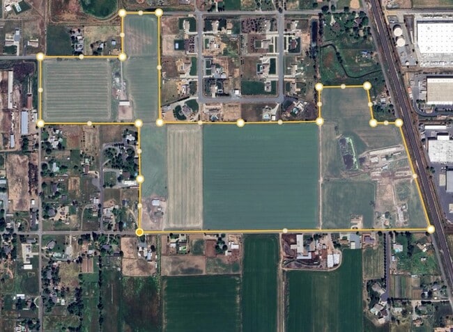
10201 Pringle Ave
Sacramento--Roseville--Arden-Arcade, CA
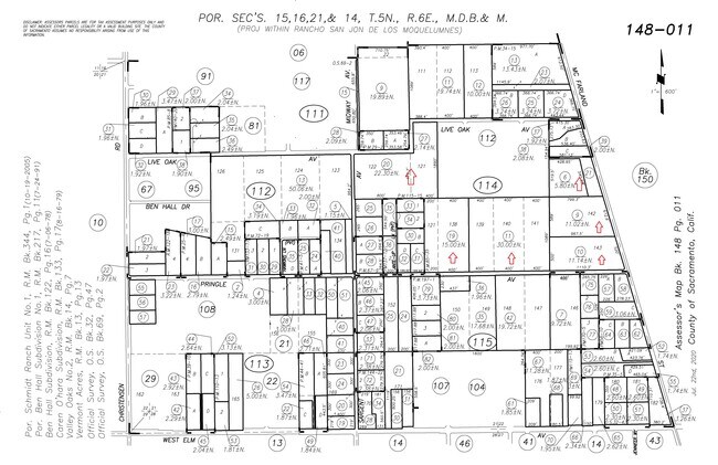
Valley Oaks 02
148-0114-010
LOT139-142; POR LOT116
Multifamilydwelling
Sacramento
X
California
06077C0050G
116
2024
11.14 AC
2025
Outer Sacramento County
009408
Sacramento
2,720 SF
DEMOGRAPHICS near 10201 Pringle Ave
1 Mile
3 Mile
5 Mile
2024 Total Population
4,267
28,352
31,136
2029 Population
4,196
28,387
31,099
Pop Growth 2024-2029
(1.66%)
+ 0.12%
(0.12%)
Average Age
42
39
39
2024 Total Households
1,452
9,059
9,925
HH Growth 2024-2029
(1.65%)
+ 0.03%
(0.20%)
Median Household Inc
$92,791
$84,394
$85,262
Avg Household Size
2.90
3.10
3.10
2024 Avg HH Vehicles
3.00
2.00
2.00
Median Home Value
$474,456
$450,571
$460,564
Median Year Built
1987
1993
1992
Nearby Places
Map Layers
Map Styles
 Street
 Aerial
- Restaurants
- Banks
- Shops
- Fitness
- Groceries
PUBLIC TRANSPORTATION
AIRPORT
Stockton Metro
DRIVE
WALK
Distance
Stockton Metro
39 min
29.5 mi
Freight Ports
Port of Stockton
DRIVE
WALK
Distance
Port of Stockton
38 min
28.0 mi
Nearby Properties
Address
Land Use
TOTAL SIZE
Lot Size
Zoning
Address
Land Use
TOTAL SIZE
Lot Size
Zoning
284,700 SF
19.12 AC
LM
Address
Land Use
TOTAL SIZE
Lot Size
Zoning
223,974 SF
12.06 AC
LM
Address
Land Use
TOTAL SIZE
Lot Size
Zoning
127,249 SF
11.18 AC
HC
Address
Land Use
TOTAL SIZE
Lot Size
Zoning
65,200 SF
5.04 AC
HC
Address
Land Use
TOTAL SIZE
Lot Size
Zoning
77,052 SF
0.93 AC
DC
Address
Land Use
TOTAL SIZE
Lot Size
Zoning
0.99 AC
HC
Address
Land Use
TOTAL SIZE
Lot Size
Zoning
149.14 AC
OS (SP) R2
Address
Land Use
TOTAL SIZE
Lot Size
Zoning
46,376 SF
4.18 AC
C
Address
Land Use
TOTAL SIZE
Lot Size
Zoning
95,616 SF
8.42 AC
R3
Address
Land Use
TOTAL SIZE
Lot Size
Zoning
4,986 SF
1.62 AC
HC
Address
Land Use
TOTAL SIZE
Lot Size
Zoning
52,000 SF
3.28 AC
C
Address
Land Use
TOTAL SIZE
Lot Size
Zoning
1.53 AC
LM
Address
Land Use
TOTAL SIZE
Lot Size
Zoning
316.88 AC
AG-80
Address
Land Use
TOTAL SIZE
Lot Size
Zoning
18,089 SF
10.36 AC
LM
Address
Land Use
TOTAL SIZE
Lot Size
Zoning
67,312 SF
10.20 AC
LM
Address
Land Use
TOTAL SIZE
Lot Size
Zoning
102,790 SF
6.29 AC
LM
Address
Land Use
TOTAL SIZE
Lot Size
Zoning
50,732 SF
6.19 AC
R2
Address
Land Use
TOTAL SIZE
Lot Size
Zoning
58 AC
R1C OS
Address
Land Use
TOTAL SIZE
Lot Size
Zoning
21,304 SF
2.91 AC
C
Address
Land Use
TOTAL SIZE
Lot Size
Zoning
47,710 SF
2.60 AC
R4
Address
Land Use
TOTAL SIZE
Lot Size
Zoning
17,340 SF
1.80 AC
C
Address
Land Use
TOTAL SIZE
Lot Size
Zoning
R1C OS
Address
Land Use
TOTAL SIZE
Lot Size
Zoning
760 SF
8.35 AC
LM
Address
Land Use
TOTAL SIZE
Lot Size
Zoning
32,567 SF
6.27 AC
R3
Address
Land Use
TOTAL SIZE
Lot Size
Zoning
8,844 SF
6.16 AC
OP
Address
Land Use
TOTAL SIZE
Lot Size
Zoning
12,804 SF
9.89 AC
PQ
Address
Land Use
TOTAL SIZE
Lot Size
Zoning
64,868 SF
3.69 AC
LM
Address
Land Use
TOTAL SIZE
Lot Size
Zoning
4.51 AC
LM
Address
Land Use
TOTAL SIZE
Lot Size
Zoning
43,000 SF
1.90 AC
HC
Address
Land Use
TOTAL SIZE
Lot Size
Zoning
32,196 SF
2.89 AC
C
The World's #1 Commercial Real Estate Marketplace
Connect with us
© 2025 CoStar Group
The information above has been obtained from sources believed reliable. While we do not doubt its accuracy we have not verified it and make no guarantee, warranty or representation about it. It is your responsibility to independently confirm its accuracy and completeness. Any projections, opinions, assumptions, or estimates used are for example only and do not represent the current or future performance of the property. The value of this transaction to you depends on tax and other factors which should be evaluated by your tax, financial, and legal advisors. You and your advisors should conduct a careful, independent investigation of the property to determine to your satisfaction the suitability of the property for your needs.