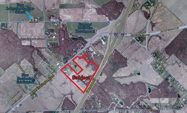
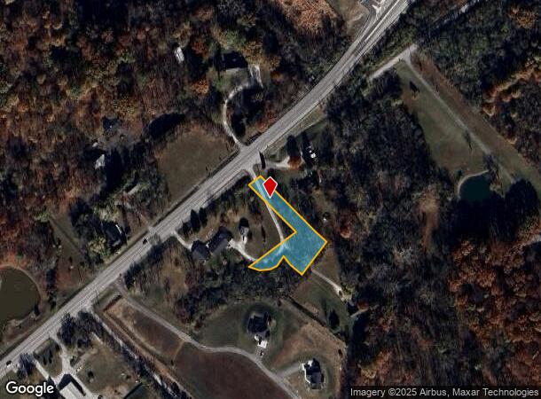
Property Record
10000 Lower Huntington Rd, Roanoke, IN 46783
NEARBY LISTINGS FOR SALE OR LEASE
Property Detail
10000 Lower Huntington Rd
Fort Wayne, IN
Seeks Reserve
02-16-10-126-004.000-048
LOT 8 SEEKS RES S OF HUNT RD EX N 900 OF W 542FT & EX TRACTS & EX PT TO
Recreationalacreage
Allen
A
Indiana
18069C0200D
8
2023
0.68 AC
2024
Outlying Allen County
011701
Fort Wayne
DEMOGRAPHICS near 10000 Lower Huntington Rd
1 Mile
3 Mile
5 Mile
2024 Total Population
1,546
9,085
24,798
2029 Population
1,601
9,395
25,621
Pop Growth 2024-2029
+ 3.56%
+ 3.41%
+ 3.32%
Average Age
38
41
41
2024 Total Households
545
3,392
9,671
HH Growth 2024-2029
+ 3.67%
+ 3.57%
+ 3.52%
Median Household Inc
$112,162
$98,686
$95,606
Avg Household Size
2.80
2.60
2.50
2024 Avg HH Vehicles
3.00
2.00
2.00
Median Home Value
$283,443
$269,059
$244,444
Median Year Built
2000
1990
1986
Nearby Places
Map Layers
Map Styles
 Street
 Aerial
- Restaurants
- Banks
- Shops
- Fitness
- Groceries
PUBLIC TRANSPORTATION
AIRPORT
Fort Wayne International
DRIVE
WALK
Distance
Fort Wayne International
11 min
5.3 mi
Freight Ports
Port of Toledo
DRIVE
WALK
Distance
Port of Toledo
151 min
120.7 mi
SALE & LEASE HISTORY
LISTING DATE
SALE/LEASE

Sep 24, 2016
For Sale
Nearby Properties
Address
Land Use
TOTAL SIZE
Lot Size
Zoning
Address
Land Use
TOTAL SIZE
Lot Size
Zoning
5,843,317 SF
704.47 AC
Address
Land Use
TOTAL SIZE
Lot Size
Zoning
806,403 SF
61.42 AC
Address
Land Use
TOTAL SIZE
Lot Size
Zoning
427,200 SF
68.74 AC
Address
Land Use
TOTAL SIZE
Lot Size
Zoning
378,063 SF
37.84 AC
Address
Land Use
TOTAL SIZE
Lot Size
Zoning
52,892 SF
137 AC
Address
Land Use
TOTAL SIZE
Lot Size
Zoning
181,852 SF
16.38 AC
Address
Land Use
TOTAL SIZE
Lot Size
Zoning
120,682 SF
95.21 AC
Address
Land Use
TOTAL SIZE
Lot Size
Zoning
99,688 SF
8.79 AC
Address
Land Use
TOTAL SIZE
Lot Size
Zoning
105,467 SF
16.33 AC
Address
Land Use
TOTAL SIZE
Lot Size
Zoning
201,000 SF
16.14 AC
Address
Land Use
TOTAL SIZE
Lot Size
Zoning
94,605 SF
11.15 AC
Address
Land Use
TOTAL SIZE
Lot Size
Zoning
39,354 SF
8.08 AC
Address
Land Use
TOTAL SIZE
Lot Size
Zoning
114,304 SF
28.33 AC
Address
Land Use
TOTAL SIZE
Lot Size
Zoning
57,993 SF
2.91 AC
Address
Land Use
TOTAL SIZE
Lot Size
Zoning
13,846 SF
5.66 AC
Address
Land Use
TOTAL SIZE
Lot Size
Zoning
17,991 SF
10 AC
Address
Land Use
TOTAL SIZE
Lot Size
Zoning
15,976 SF
6.17 AC
Address
Land Use
TOTAL SIZE
Lot Size
Zoning
76,960 SF
15.27 AC
Address
Land Use
TOTAL SIZE
Lot Size
Zoning
8,800 SF
3.59 AC
Address
Land Use
TOTAL SIZE
Lot Size
Zoning
12,736 SF
14.85 AC
Address
Land Use
TOTAL SIZE
Lot Size
Zoning
9,252 SF
12 AC
Address
Land Use
TOTAL SIZE
Lot Size
Zoning
33,420 SF
57.77 AC
Address
Land Use
TOTAL SIZE
Lot Size
Zoning
14,412 SF
2.70 AC
Address
Land Use
TOTAL SIZE
Lot Size
Zoning
11,737 SF
117.87 AC
Address
Land Use
TOTAL SIZE
Lot Size
Zoning
9,304 SF
21.27 AC
Address
Land Use
TOTAL SIZE
Lot Size
Zoning
9,302 SF
12.79 AC
Address
Land Use
TOTAL SIZE
Lot Size
Zoning
9,601 SF
88.61 AC
Address
Land Use
TOTAL SIZE
Lot Size
Zoning
51,590 SF
12.42 AC
Address
Land Use
TOTAL SIZE
Lot Size
Zoning
16,696 SF
2.99 AC
Address
Land Use
TOTAL SIZE
Lot Size
Zoning
16,150 SF
28.55 AC
The World's #1 Commercial Real Estate Marketplace
Connect with us
© 2025 CoStar Group
The information above has been obtained from sources believed reliable. While we do not doubt its accuracy we have not verified it and make no guarantee, warranty or representation about it. It is your responsibility to independently confirm its accuracy and completeness. Any projections, opinions, assumptions, or estimates used are for example only and do not represent the current or future performance of the property. The value of this transaction to you depends on tax and other factors which should be evaluated by your tax, financial, and legal advisors. You and your advisors should conduct a careful, independent investigation of the property to determine to your satisfaction the suitability of the property for your needs.