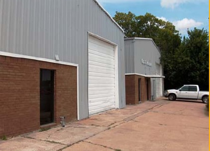
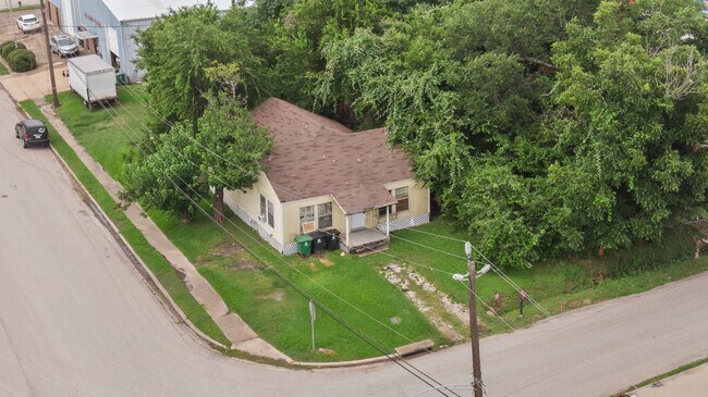
Property Record
6001 Teague Rd, Houston, TX 77041


Property Detail
6001 Teague Rd
Houston-Pasadena-The Woodlands, TX
LTS 353 & 354 BLK H CARVERDALE SEC 1
0771970080353
HARRIS
Warehouse
Texas
B and X Area of moderate flood hazard, usually the area between the limits of the 100-year and 500-year floods.
353
2025
0.32 AC
2025
Northwest Inner Loop
521600
Houston
7,500 SF
NEARBY LISTINGS FOR SALE OR LEASE
DEMOGRAPHICS near 6001 Teague Rd
1 mile
3 mile
5 mile
2025 Total Population
3,302
90,673
292,099
2030 Population
3,568
96,348
310,369
Pop Growth 2025-2030
+ 8.06%
+ 6.26%
+ 6.25%
Average Age
36
38
37
2025 Total Households
1,049
32,517
104,051
HH Growth 2025-2030
+ 7.91%
+ 6.46%
+ 6.47%
Median Household Inc
$82,886
$69,610
$66,234
Avg Household Size
3.00
2.70
2.70
2025 Avg HH Vehicles
2.00
2.00
2.00
Median Home Value
$242,857
$292,173
$288,193
Median Year Built
2000
1982
1982
Nearby Places
Map Layers
Map Styles
 Street
 Aerial
Layers
 Traffic
 Biking
Places
Listings with unknown addresses are not visible on the map
- Restaurants
- Banks
- Shops
- Fitness
- Groceries
PUBLIC TRANSPORTATION
AIRPORT
George Bush Intcntl/Houston
Drive
Walk
Distance
George Bush Intcntl/Houston
29 min
22.1 mi
William P Hobby
Drive
Walk
Distance
William P Hobby
44 min
28.1 mi
Freight Ports
Port of Houston
Drive
Walk
Distance
Port of Houston
36 min
23.7 mi
SALE & LEASE HISTORY
LISTING DATE
SALE/LEASE

Aug 23, 2025
For Sale
Nearby Properties
Address
Land Use
TOTAL SIZE
Lot Size
Zoning
Address
Land Use
TOTAL SIZE
Lot Size
Zoning
578,530 SF
32.81 AC
Address
Land Use
TOTAL SIZE
Lot Size
Zoning
793,669 SF
121.83 AC
Address
Land Use
TOTAL SIZE
Lot Size
Zoning
643,804 SF
31.40 AC
Address
Land Use
TOTAL SIZE
Lot Size
Zoning
342,163 SF
8.50 AC
Address
Land Use
TOTAL SIZE
Lot Size
Zoning
427,921 SF
18.14 AC
Address
Land Use
TOTAL SIZE
Lot Size
Zoning
336,681 SF
16.10 AC
Address
Land Use
TOTAL SIZE
Lot Size
Zoning
456,294 SF
19.02 AC
Address
Land Use
TOTAL SIZE
Lot Size
Zoning
647,228 SF
9.85 AC
Address
Land Use
TOTAL SIZE
Lot Size
Zoning
408,730 SF
24.68 AC
Address
Land Use
TOTAL SIZE
Lot Size
Zoning
802,913 SF
27.11 AC
Address
Land Use
TOTAL SIZE
Lot Size
Zoning
281,843 SF
13.97 AC
Address
Land Use
TOTAL SIZE
Lot Size
Zoning
312,065 SF
17.83 AC
Address
Land Use
TOTAL SIZE
Lot Size
Zoning
157,698 SF
5.98 AC
Address
Land Use
TOTAL SIZE
Lot Size
Zoning
426,748 SF
26.09 AC
Address
Land Use
TOTAL SIZE
Lot Size
Zoning
401,600 SF
20.48 AC
Address
Land Use
TOTAL SIZE
Lot Size
Zoning
172,326 SF
8.07 AC
Address
Land Use
TOTAL SIZE
Lot Size
Zoning
350,057 SF
19.96 AC
Address
Land Use
TOTAL SIZE
Lot Size
Zoning
409,271 SF
20.70 AC
Address
Land Use
TOTAL SIZE
Lot Size
Zoning
347,694 SF
17.61 AC
Address
Land Use
TOTAL SIZE
Lot Size
Zoning
447,480 SF
18.48 AC
Address
Land Use
TOTAL SIZE
Lot Size
Zoning
357,300 SF
23.38 AC
Address
Land Use
TOTAL SIZE
Lot Size
Zoning
185,252 SF
17.14 AC
Address
Land Use
TOTAL SIZE
Lot Size
Zoning
287,212 SF
12.52 AC
Address
Land Use
TOTAL SIZE
Lot Size
Zoning
472,988 SF
9 AC
Address
Land Use
TOTAL SIZE
Lot Size
Zoning
212,017 SF
14.11 AC
Address
Land Use
TOTAL SIZE
Lot Size
Zoning
251,461 SF
21.74 AC
Address
Land Use
TOTAL SIZE
Lot Size
Zoning
418,892 SF
19.81 AC
Address
Land Use
TOTAL SIZE
Lot Size
Zoning
358,361 SF
11.35 AC
Address
Land Use
TOTAL SIZE
Lot Size
Zoning
403,200 SF
20.53 AC
Address
Land Use
TOTAL SIZE
Lot Size
Zoning
272,209 SF
18.15 AC
The World's #1 Commercial Real Estate Marketplace
Connect with us
© 2026 CoStar Group
The information above has been obtained from sources believed reliable. While we do not doubt its accuracy we have not verified it and make no guarantee, warranty or representation about it. It is your responsibility to independently confirm its accuracy and completeness. Any projections, opinions, assumptions, or estimates used are for example only and do not represent the current or future performance of the property. The value of this transaction to you depends on tax and other factors which should be evaluated by your tax, financial, and legal advisors. You and your advisors should conduct a careful, independent investigation of the property to determine to your satisfaction the suitability of the property for your needs.