Property Record
10002 Johns Rd, Boerne, TX 78006
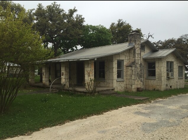

Property Detail
10002 Johns Rd
14445
A10311 - SURVEY 177 A LOCKMAR 1.296 ACRES
Commercialbuilding
Kendall
B and X Area of moderate flood hazard, usually the area between the limits of the 100-year and 500-year floods.
Texas
2024
1.30 AC
2025
Kendall County
970302
San Antonio
4,747 SF
San Antonio-New Braunfels, TX
NEARBY LISTINGS FOR SALE OR LEASE
DEMOGRAPHICS near 10002 Johns Rd
1 mile
3 mile
5 mile
2025 Total Population
706
11,391
28,749
2030 Population
786
12,837
32,494
Pop Growth 2025-2030
+ 11.33%
+ 12.69%
+ 13.03%
Average Age
46
44
43
2025 Total Households
292
4,538
10,795
HH Growth 2025-2030
+ 11.30%
+ 12.78%
+ 13.15%
Median Household Inc
$71,785
$84,296
$93,740
Avg Household Size
2.40
2.50
2.60
2025 Avg HH Vehicles
2.00
2.00
2.00
Median Home Value
$399,999
$479,479
$485,981
Median Year Built
1993
2002
2003
Nearby Places
Map Layers
Map Styles
 Street
 Aerial
Transit
 Traffic
 Biking
Places
Listings with unknown addresses are not visible on the map
- Restaurants
- Banks
- Shops
- Fitness
- Groceries
PUBLIC TRANSPORTATION
AIRPORT
San Antonio International
Drive
Walk
Distance
San Antonio International
35 min
29.6 mi
Freight Ports
Calhoun Port
Drive
Walk
Distance
Calhoun Port
214 min
181.3 mi
SALE & LEASE HISTORY
LISTING DATE
SALE/LEASE

Sep 25, 2016
For Lease
Jan 29, 2019
For Lease
Nearby Properties
Address
Land Use
TOTAL SIZE
Lot Size
Zoning
Address
Land Use
TOTAL SIZE
Lot Size
Zoning
236,676 SF
55.67 AC
Address
Land Use
TOTAL SIZE
Lot Size
Zoning
384,453 SF
34.24 AC
Address
Land Use
TOTAL SIZE
Lot Size
Zoning
135,904 SF
10.40 AC
Address
Land Use
TOTAL SIZE
Lot Size
Zoning
86,050 SF
25.59 AC
Address
Land Use
TOTAL SIZE
Lot Size
Zoning
78,586 SF
15.36 AC
Address
Land Use
TOTAL SIZE
Lot Size
Zoning
111,517 SF
20.86 AC
Address
Land Use
TOTAL SIZE
Lot Size
Zoning
91,430 SF
3.99 AC
Address
Land Use
TOTAL SIZE
Lot Size
Zoning
90,958 SF
19.64 AC
Address
Land Use
TOTAL SIZE
Lot Size
Zoning
83,845 SF
7.32 AC
Address
Land Use
TOTAL SIZE
Lot Size
Zoning
215,475 SF
13.14 AC
Address
Land Use
TOTAL SIZE
Lot Size
Zoning
257,805 SF
15.54 AC
Address
Land Use
TOTAL SIZE
Lot Size
Zoning
4,080 SF
302.27 AC
Address
Land Use
TOTAL SIZE
Lot Size
Zoning
185,555 SF
11.76 AC
Address
Land Use
TOTAL SIZE
Lot Size
Zoning
43,470 SF
1.77 AC
Address
Land Use
TOTAL SIZE
Lot Size
Zoning
80,546 SF
4.66 AC
Address
Land Use
TOTAL SIZE
Lot Size
Zoning
1,924 SF
103.24 AC
Address
Land Use
TOTAL SIZE
Lot Size
Zoning
185,852 SF
22.38 AC
Address
Land Use
TOTAL SIZE
Lot Size
Zoning
70,036 SF
0.77 AC
Address
Land Use
TOTAL SIZE
Lot Size
Zoning
57,717 SF
3.78 AC
Address
Land Use
TOTAL SIZE
Lot Size
Zoning
54,854 SF
4.44 AC
Address
Land Use
TOTAL SIZE
Lot Size
Zoning
86,137 SF
Address
Land Use
TOTAL SIZE
Lot Size
Zoning
119,256 SF
12.59 AC
Address
Land Use
TOTAL SIZE
Lot Size
Zoning
8,515 SF
59.67 AC
Address
Land Use
TOTAL SIZE
Lot Size
Zoning
128,730 SF
Address
Land Use
TOTAL SIZE
Lot Size
Zoning
49,307 SF
1.07 AC
Address
Land Use
TOTAL SIZE
Lot Size
Zoning
29,732 SF
2.85 AC
Address
Land Use
TOTAL SIZE
Lot Size
Zoning
48,975 SF
2.98 AC
Address
Land Use
TOTAL SIZE
Lot Size
Zoning
20,834 SF
161.08 AC
Address
Land Use
TOTAL SIZE
Lot Size
Zoning
30,448 SF
4.18 AC
Address
Land Use
TOTAL SIZE
Lot Size
Zoning
21,868 SF
19.88 AC
The World's #1 Commercial Real Estate Marketplace
Connect with us
© 2026 CoStar Group
The information above has been obtained from sources believed reliable. While we do not doubt its accuracy we have not verified it and make no guarantee, warranty or representation about it. It is your responsibility to independently confirm its accuracy and completeness. Any projections, opinions, assumptions, or estimates used are for example only and do not represent the current or future performance of the property. The value of this transaction to you depends on tax and other factors which should be evaluated by your tax, financial, and legal advisors. You and your advisors should conduct a careful, independent investigation of the property to determine to your satisfaction the suitability of the property for your needs.