Property Record
10005 Hartland Rd, Fenton, MI 48430
NEARBY LISTINGS FOR SALE OR LEASE
-
-
View all Fenton listings for sale on LoopNet.com
Property Detail
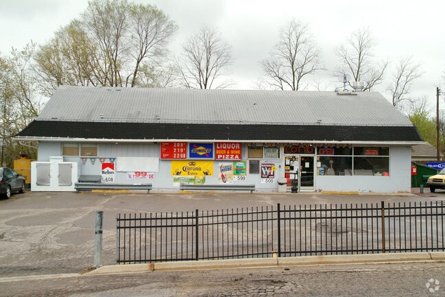
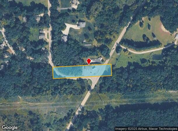
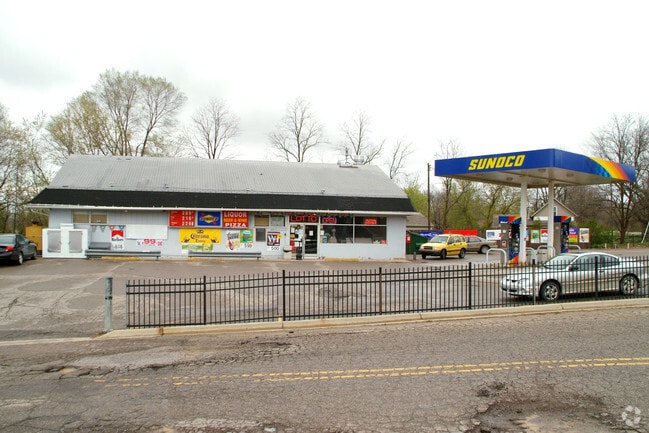
10005 Hartland Rd
04-10-300-017
SEC. 10 T4N, R6E, BEG. AT SE COR. OF SW 1/4 OF SW 1/4 SEC. 10, N 11 1/2 RDS., W 35 RDS., S 11 1/2 RDS., E 35 RDS. TO BEG.
Commercialnec
Livingston
X
Michigan
26049C0440D
1.51 AC
2025
Livingston County
2025
Detroit
710500
Detroit-Warren-Dearborn, MI
2,800 SF
DEMOGRAPHICS near 10005 Hartland Rd
1 Mile
3 Mile
5 Mile
2024 Total Population
1,208
13,423
39,002
2029 Population
1,240
13,433
38,901
Pop Growth 2024-2029
+ 2.65%
+ 0.07%
(0.26%)
Average Age
43
43
42
2024 Total Households
442
5,223
15,306
HH Growth 2024-2029
+ 2.49%
(0.19%)
(0.46%)
Median Household Inc
$111,071
$91,958
$88,829
Avg Household Size
2.70
2.50
2.50
2024 Avg HH Vehicles
2.00
2.00
2.00
Median Home Value
$380,596
$302,637
$286,579
Median Year Built
1977
1983
1984
Nearby Places
Map Layers
Map Styles
 Street
 Aerial
- Restaurants
- Banks
- Shops
- Fitness
- Groceries
PUBLIC TRANSPORTATION
AIRPORT
Bishop International
DRIVE
WALK
Distance
Bishop International
32 min
17.5 mi
Freight Ports
Port of Toledo
DRIVE
WALK
Distance
Port of Toledo
117 min
94.7 mi
SALE & LEASE HISTORY
LISTING DATE
SALE/LEASE

May 14, 2024
For Sale
Nearby Properties
Address
Land Use
TOTAL SIZE
Lot Size
Zoning
Address
Land Use
TOTAL SIZE
Lot Size
Zoning
30,286 SF
3.29 AC
SEVERAL
Address
Land Use
TOTAL SIZE
Lot Size
Zoning
215,494 SF
25.02 AC
GBD
Address
Land Use
TOTAL SIZE
Lot Size
Zoning
162,144 SF
8 AC
PUD
Address
Land Use
TOTAL SIZE
Lot Size
Zoning
82,447 SF
8.96 AC
GBD
Address
Land Use
TOTAL SIZE
Lot Size
Zoning
87,925 SF
13.49 AC
GBD
Address
Land Use
TOTAL SIZE
Lot Size
Zoning
87,847 SF
12.71 AC
GBD
Address
Land Use
TOTAL SIZE
Lot Size
Zoning
126,064 SF
10.80 AC
GBD
Address
Land Use
TOTAL SIZE
Lot Size
Zoning
192,000 SF
30.75 AC
M-1
Address
Land Use
TOTAL SIZE
Lot Size
Zoning
131,290 SF
22.33 AC
PCI
Address
Land Use
TOTAL SIZE
Lot Size
Zoning
112,330 SF
11.82 AC
IND
Address
Land Use
TOTAL SIZE
Lot Size
Zoning
46,732 SF
10.50 AC
SEVERAL
Address
Land Use
TOTAL SIZE
Lot Size
Zoning
8,902 SF
233.33 AC
RE
Address
Land Use
TOTAL SIZE
Lot Size
Zoning
44,343 SF
3.94 AC
NO DATA TO
Address
Land Use
TOTAL SIZE
Lot Size
Zoning
48,096 SF
6.39 AC
GBD
Address
Land Use
TOTAL SIZE
Lot Size
Zoning
26,719 SF
4.07 AC
GBD
Address
Land Use
TOTAL SIZE
Lot Size
Zoning
96,750 SF
10.15 AC
PCI
Address
Land Use
TOTAL SIZE
Lot Size
Zoning
47,372 SF
7.12 AC
GBD
Address
Land Use
TOTAL SIZE
Lot Size
Zoning
20,969 SF
3.67 AC
LDR
Address
Land Use
TOTAL SIZE
Lot Size
Zoning
19,650 SF
2.70 AC
GBD
Address
Land Use
TOTAL SIZE
Lot Size
Zoning
59,089 SF
10.29 AC
IND
Address
Land Use
TOTAL SIZE
Lot Size
Zoning
2,656 SF
66 AC
MHP
Address
Land Use
TOTAL SIZE
Lot Size
Zoning
70,541 SF
6.05 AC
IND
Address
Land Use
TOTAL SIZE
Lot Size
Zoning
24,221 SF
4.74 AC
GBD
Address
Land Use
TOTAL SIZE
Lot Size
Zoning
47 AC
SEVERAL
Address
Land Use
TOTAL SIZE
Lot Size
Zoning
23,627 SF
3.38 AC
GBD
Address
Land Use
TOTAL SIZE
Lot Size
Zoning
7,343 SF
95 AC
FR
Address
Land Use
TOTAL SIZE
Lot Size
Zoning
85,698 SF
10.66 AC
IND
Address
Land Use
TOTAL SIZE
Lot Size
Zoning
8,026 SF
2.77 AC
GBD
Address
Land Use
TOTAL SIZE
Lot Size
Zoning
24,984 SF
22.82 AC
RM-1
Address
Land Use
TOTAL SIZE
Lot Size
Zoning
20.71 AC
MHP
The World's #1 Commercial Real Estate Marketplace
Connect with us
© 2026 CoStar Group
The information above has been obtained from sources believed reliable. While we do not doubt its accuracy we have not verified it and make no guarantee, warranty or representation about it. It is your responsibility to independently confirm its accuracy and completeness. Any projections, opinions, assumptions, or estimates used are for example only and do not represent the current or future performance of the property. The value of this transaction to you depends on tax and other factors which should be evaluated by your tax, financial, and legal advisors. You and your advisors should conduct a careful, independent investigation of the property to determine to your satisfaction the suitability of the property for your needs.