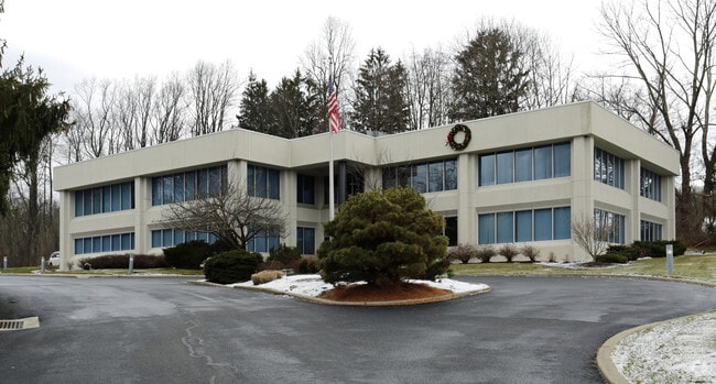
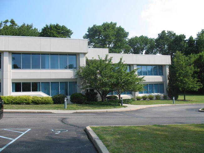
Property Record
1001 County Road 517, Hackettstown, NJ 07840


NEARBY LISTINGS FOR SALE OR LEASE
-
-
View all Hackettstown listings for sale on LoopNet.com
Property Detail
1001 County Road 517
01-00802-0000-00010
Warren
Officebuilding
New Jersey
A
10
34041C0165E
6.69 AC
2024
Warren County
2025
Northern New Jersey
031302
Allentown-Bethlehem-Easton, PA-NJ
DEMOGRAPHICS near 1001 County Road 517
1 Mile
3 Mile
5 Mile
2024 Total Population
709
18,757
43,196
2029 Population
727
18,980
43,394
Pop Growth 2024-2029
+ 2.54%
+ 1.19%
+ 0.46%
Average Age
45
43
42
2024 Total Households
328
7,551
16,852
HH Growth 2024-2029
+ 2.44%
+ 1.42%
+ 0.55%
Median Household Inc
$103,773
$98,634
$97,024
Avg Household Size
2.10
2.40
2.50
2024 Avg HH Vehicles
2.00
2.00
2.00
Median Home Value
$315,000
$341,152
$364,088
Median Year Built
1987
1980
1979
Nearby Places
Map Layers
Map Styles
 Street
 Aerial
- Restaurants
- Banks
- Shops
- Fitness
- Groceries
PUBLIC TRANSPORTATION
COMMUTER RAIL
Hackettstown (Montclair-Boonton Line - NJ Transit Commuter Rail (NJ Transit), Morris & Essex Morristown Line - NJ Transit Commuter Rail (NJ Transit))
DRIVE
WALK
Distance
Hackettstown (Montclair-Boonton Line - NJ Transit Commuter Rail (NJ Transit), Morris & Essex Morristown Line - NJ Transit Commuter Rail (NJ Transit))
7 min
2.8 mi
Mount Olive (Montclair-Boonton Line - NJ Transit Commuter Rail (NJ Transit), Morris & Essex Morristown Line - NJ Transit Commuter Rail (NJ Transit))
DRIVE
WALK
Distance
Mount Olive (Montclair-Boonton Line - NJ Transit Commuter Rail (NJ Transit), Morris & Essex Morristown Line - NJ Transit Commuter Rail (NJ Transit))
16 min
9.4 mi
AIRPORT
Lehigh Valley International
DRIVE
WALK
Distance
Lehigh Valley International
72 min
42.3 mi
Newark Liberty International
DRIVE
WALK
Distance
Newark Liberty International
61 min
47.5 mi
Freight Ports
Maher Terminal
DRIVE
WALK
Distance
Maher Terminal
65 min
48.6 mi
Nearby Properties
Address
Land Use
TOTAL SIZE
Lot Size
Zoning
Address
Land Use
TOTAL SIZE
Lot Size
Zoning
521,918 SF
61.60 AC
LM
Address
Land Use
TOTAL SIZE
Lot Size
Zoning
16,916 SF
39.96 AC
R30
Address
Land Use
TOTAL SIZE
Lot Size
Zoning
187,660 SF
15 AC
HF
Address
Land Use
TOTAL SIZE
Lot Size
Zoning
Address
Land Use
TOTAL SIZE
Lot Size
Zoning
127,307 SF
26.84 AC
C2
Address
Land Use
TOTAL SIZE
Lot Size
Zoning
161,776 SF
18.75 AC
FTZ2
Address
Land Use
TOTAL SIZE
Lot Size
Zoning
2,420 SF
2.55 AC
Address
Land Use
TOTAL SIZE
Lot Size
Zoning
180,814 SF
15 AC
LM
Address
Land Use
TOTAL SIZE
Lot Size
Zoning
49,430 SF
5 AC
HF
Address
Land Use
TOTAL SIZE
Lot Size
Zoning
74.59 AC
PPE
Address
Land Use
TOTAL SIZE
Lot Size
Zoning
2,046 SF
13.54 AC
C2
Address
Land Use
TOTAL SIZE
Lot Size
Zoning
41,361 SF
8.86 AC
HF
Address
Land Use
TOTAL SIZE
Lot Size
Zoning
45,090 SF
4.78 AC
LM
Address
Land Use
TOTAL SIZE
Lot Size
Zoning
69,380 SF
3.58 AC
HF
Address
Land Use
TOTAL SIZE
Lot Size
Zoning
37,794 SF
14.28 AC
HF
Address
Land Use
TOTAL SIZE
Lot Size
Zoning
8,008 SF
6.94 AC
APT
Address
Land Use
TOTAL SIZE
Lot Size
Zoning
40,630 SF
14.10 AC
HF
Address
Land Use
TOTAL SIZE
Lot Size
Zoning
36,196 SF
3.57 AC
HF
Address
Land Use
TOTAL SIZE
Lot Size
Zoning
94,420 SF
2.49 AC
R125
Address
Land Use
TOTAL SIZE
Lot Size
Zoning
77,900 SF
5.60 AC
LM
Address
Land Use
TOTAL SIZE
Lot Size
Zoning
Address
Land Use
TOTAL SIZE
Lot Size
Zoning
1,512 SF
1.85 AC
CC
Address
Land Use
TOTAL SIZE
Lot Size
Zoning
3.20 AC
Address
Land Use
TOTAL SIZE
Lot Size
Zoning
13,488 SF
0.31 AC
APT
Address
Land Use
TOTAL SIZE
Lot Size
Zoning
7.84 AC
CC
Address
Land Use
TOTAL SIZE
Lot Size
Zoning
3,600 SF
43.10 AC
LM
Address
Land Use
TOTAL SIZE
Lot Size
Zoning
8,736 SF
12.33 AC
C-2
Address
Land Use
TOTAL SIZE
Lot Size
Zoning
57,498 SF
4.21 AC
LM
Address
Land Use
TOTAL SIZE
Lot Size
Zoning
5.96 AC
CC
Address
Land Use
TOTAL SIZE
Lot Size
Zoning
20,946 SF
4.20 AC
LM
The World's #1 Commercial Real Estate Marketplace
Connect with us
© 2025 CoStar Group
The information above has been obtained from sources believed reliable. While we do not doubt its accuracy we have not verified it and make no guarantee, warranty or representation about it. It is your responsibility to independently confirm its accuracy and completeness. Any projections, opinions, assumptions, or estimates used are for example only and do not represent the current or future performance of the property. The value of this transaction to you depends on tax and other factors which should be evaluated by your tax, financial, and legal advisors. You and your advisors should conduct a careful, independent investigation of the property to determine to your satisfaction the suitability of the property for your needs.