Property Record
1001 Crossroads Pl, High Ridge, MO 63049


Save to a Folder
{{folder.Name}}
{{folder.ListingIds.length}} Properties
{{folder.ListingIds.length}} Property
Create a New Folder
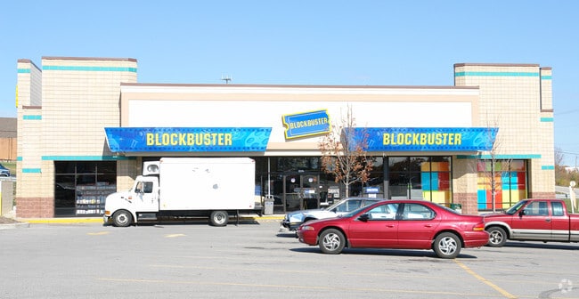
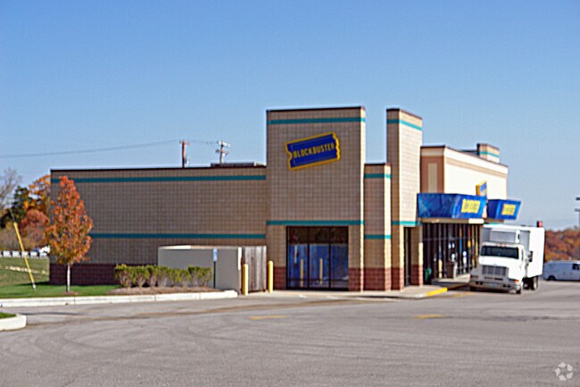
Property Detail
1001 Crossroads Pl
03-6.0-13.0-3-001-002
RIDGEWOOD ACRES BDRY ADJ LOT 2A
Storebuilding
Jefferson
CC2
Missouri
B and X Area of moderate flood hazard, usually the area between the limits of the 100-year and 500-year floods.
2a
2024
8.41 AC
2025
Southwest County
700306
St. Louis
76,636 SF
St. Louis, MO-IL
NEARBY LISTINGS FOR SALE OR LEASE
-
-
View all High Ridge listings for sale on LoopNet.com
DEMOGRAPHICS near 1001 Crossroads Pl
1 mile
3 mile
5 mile
2025 Total Population
4,685
22,861
65,975
2030 Population
4,730
23,259
66,739
Pop Growth 2025-2030
+ 0.96%
+ 1.74%
+ 1.16%
Average Age
42
42
41
2025 Total Households
1,909
9,022
25,291
HH Growth 2025-2030
+ 1.10%
+ 1.78%
+ 1.21%
Median Household Inc
$78,468
$87,657
$91,369
Avg Household Size
2.40
2.50
2.60
2025 Avg HH Vehicles
2.00
2.00
2.00
Median Home Value
$190,224
$221,847
$258,189
Median Year Built
1978
1983
1985
Nearby Places
Map Layers
Map Styles
 Street
 Aerial
Layers
 Traffic
 Biking
Places
Listings with unknown addresses are not visible on the map
- Restaurants
- Banks
- Shops
- Fitness
- Groceries
PUBLIC TRANSPORTATION
AIRPORT
St Louis Lambert International
Drive
Walk
Distance
St Louis Lambert International
43 min
29.5 mi
Freight Ports
Tulsa Port of Inola
Drive
Walk
Distance
Tulsa Port of Inola
408 min
367.7 mi
Nearby Properties
Address
Land Use
TOTAL SIZE
Lot Size
Zoning
Address
Land Use
TOTAL SIZE
Lot Size
Zoning
28,790 SF
1,196.80 AC
NU
Address
Land Use
TOTAL SIZE
Lot Size
Zoning
258,312 SF
16.34 AC
CC2
Address
Land Use
TOTAL SIZE
Lot Size
Zoning
155,242 SF
22.76 AC
R09
Address
Land Use
TOTAL SIZE
Lot Size
Zoning
108,535 SF
14.09 AC
PUD
Address
Land Use
TOTAL SIZE
Lot Size
Zoning
186,525 SF
20.80 AC
R20
Address
Land Use
TOTAL SIZE
Lot Size
Zoning
30,189 SF
7.80 AC
CC2
Address
Land Use
TOTAL SIZE
Lot Size
Zoning
1,910 SF
5.19 AC
R40
Address
Land Use
TOTAL SIZE
Lot Size
Zoning
273,663 SF
18.81 AC
R09
Address
Land Use
TOTAL SIZE
Lot Size
Zoning
108,211 SF
15.18 AC
PI
Address
Land Use
TOTAL SIZE
Lot Size
Zoning
57,518 SF
4.88 AC
R09
Address
Land Use
TOTAL SIZE
Lot Size
Zoning
22,768 SF
2.91 AC
Address
Land Use
TOTAL SIZE
Lot Size
Zoning
75,099 SF
2.74 AC
CC2
Address
Land Use
TOTAL SIZE
Lot Size
Zoning
93,250 SF
2.63 AC
PUD
Address
Land Use
TOTAL SIZE
Lot Size
Zoning
14,612 SF
2.19 AC
CC2
Address
Land Use
TOTAL SIZE
Lot Size
Zoning
15,064 SF
2.34 AC
CC2
Address
Land Use
TOTAL SIZE
Lot Size
Zoning
85,156 SF
9.27 AC
CC2
Address
Land Use
TOTAL SIZE
Lot Size
Zoning
39,276 SF
4.93 AC
CC2
Address
Land Use
TOTAL SIZE
Lot Size
Zoning
30,896 SF
6.01 AC
CC2
Address
Land Use
TOTAL SIZE
Lot Size
Zoning
50,353 SF
2.59 AC
CC2
Address
Land Use
TOTAL SIZE
Lot Size
Zoning
51,166 SF
6.09 AC
CC2
Address
Land Use
TOTAL SIZE
Lot Size
Zoning
4,514 SF
1.76 AC
CC2
Address
Land Use
TOTAL SIZE
Lot Size
Zoning
6,488 SF
1.06 AC
PUD
Address
Land Use
TOTAL SIZE
Lot Size
Zoning
31,680 SF
1.45 AC
PI
Address
Land Use
TOTAL SIZE
Lot Size
Zoning
4,392 SF
1.71 AC
Address
Land Use
TOTAL SIZE
Lot Size
Zoning
3,426 SF
1.76 AC
Address
Land Use
TOTAL SIZE
Lot Size
Zoning
2,340 SF
1.67 AC
CC2
Address
Land Use
TOTAL SIZE
Lot Size
Zoning
4,476 SF
1.37 AC
PUD
Address
Land Use
TOTAL SIZE
Lot Size
Zoning
11,484 SF
2.11 AC
CC2
Address
Land Use
TOTAL SIZE
Lot Size
Zoning
54,575 SF
3.78 AC
CC2
The World's #1 Commercial Real Estate Marketplace
Connect with us
© 2026 CoStar Group
The information above has been obtained from sources believed reliable. While we do not doubt its accuracy we have not verified it and make no guarantee, warranty or representation about it. It is your responsibility to independently confirm its accuracy and completeness. Any projections, opinions, assumptions, or estimates used are for example only and do not represent the current or future performance of the property. The value of this transaction to you depends on tax and other factors which should be evaluated by your tax, financial, and legal advisors. You and your advisors should conduct a careful, independent investigation of the property to determine to your satisfaction the suitability of the property for your needs.