Property Record
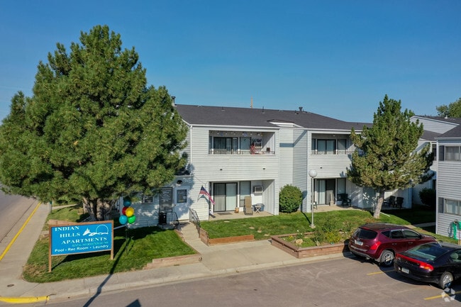
1001 E 12Th St, Gillette, WY 82716


Property Detail
1001 E 12Th St
R0002561
INDIAN HILLS PUD APT COMPLEX, TRACT 37
Apartmenthouse5plusunits
Campbell
B and X Area of moderate flood hazard, usually the area between the limits of the 100-year and 500-year floods.
Wyoming
2024
3.96 AC
2025
Wyoming Area
000400
Other Market Areas
90,760 SF
Gillette, WY
NEARBY LISTINGS FOR SALE OR LEASE
-
-
View all Gillette listings for sale on LoopNet.com
DEMOGRAPHICS near 1001 E 12Th St
1 mile
3 mile
5 mile
2025 Total Population
6,323
30,913
38,342
2030 Population
6,559
32,132
39,763
Pop Growth 2025-2030
+ 3.73%
+ 3.94%
+ 3.71%
Average Age
37
36
36
2025 Total Households
2,644
11,867
14,616
HH Growth 2025-2030
+ 3.86%
+ 4.03%
+ 3.80%
Median Household Inc
$72,980
$85,416
$89,901
Avg Household Size
2.30
2.50
2.50
2025 Avg HH Vehicles
2.00
2.00
2.00
Median Home Value
$240,608
$259,400
$268,097
Median Year Built
1976
1988
1989
Nearby Places
Map Layers
Map Styles
 Street
 Aerial
Layers
 Traffic
 Biking
Places
Listings with unknown addresses are not visible on the map
- Restaurants
- Banks
- Shops
- Fitness
- Groceries
Nearby Properties
Address
Land Use
TOTAL SIZE
Lot Size
Zoning
Address
Land Use
TOTAL SIZE
Lot Size
Zoning
154,664 SF
33.94 AC
Address
Land Use
TOTAL SIZE
Lot Size
Zoning
251,351 SF
9.22 AC
Address
Land Use
TOTAL SIZE
Lot Size
Zoning
212,478 SF
16.33 AC
Address
Land Use
TOTAL SIZE
Lot Size
Zoning
121,282 SF
7 AC
Address
Land Use
TOTAL SIZE
Lot Size
Zoning
112,541 SF
4.22 AC
Address
Land Use
TOTAL SIZE
Lot Size
Zoning
208,513 SF
11.57 AC
Address
Land Use
TOTAL SIZE
Lot Size
Zoning
95,399 SF
9.64 AC
Address
Land Use
TOTAL SIZE
Lot Size
Zoning
139,392 SF
7.35 AC
Address
Land Use
TOTAL SIZE
Lot Size
Zoning
101,890 SF
12.89 AC
Address
Land Use
TOTAL SIZE
Lot Size
Zoning
87,293 SF
6.15 AC
Address
Land Use
TOTAL SIZE
Lot Size
Zoning
121,543 SF
0.79 AC
Address
Land Use
TOTAL SIZE
Lot Size
Zoning
54,956 SF
1.85 AC
Address
Land Use
TOTAL SIZE
Lot Size
Zoning
68,510 SF
2.53 AC
Address
Land Use
TOTAL SIZE
Lot Size
Zoning
121,307 SF
5.28 AC
Address
Land Use
TOTAL SIZE
Lot Size
Zoning
70,450 SF
6.57 AC
Address
Land Use
TOTAL SIZE
Lot Size
Zoning
67,200 SF
4.89 AC
Address
Land Use
TOTAL SIZE
Lot Size
Zoning
53,670 SF
1.67 AC
Address
Land Use
TOTAL SIZE
Lot Size
Zoning
48,094 SF
2.64 AC
Address
Land Use
TOTAL SIZE
Lot Size
Zoning
65,966 SF
9.89 AC
Address
Land Use
TOTAL SIZE
Lot Size
Zoning
78,320 SF
7.52 AC
Address
Land Use
TOTAL SIZE
Lot Size
Zoning
53,373 SF
4.26 AC
Address
Land Use
TOTAL SIZE
Lot Size
Zoning
61,928 SF
3.63 AC
Address
Land Use
TOTAL SIZE
Lot Size
Zoning
42,891 SF
2.15 AC
Address
Land Use
TOTAL SIZE
Lot Size
Zoning
85,920 SF
3.25 AC
Address
Land Use
TOTAL SIZE
Lot Size
Zoning
65,512 SF
3.14 AC
Address
Land Use
TOTAL SIZE
Lot Size
Zoning
71,720 SF
10 AC
Address
Land Use
TOTAL SIZE
Lot Size
Zoning
42,369 SF
40.97 AC
Address
Land Use
TOTAL SIZE
Lot Size
Zoning
41,466 SF
1.77 AC
Address
Land Use
TOTAL SIZE
Lot Size
Zoning
41,295 SF
7.61 AC
The World's #1 Commercial Real Estate Marketplace
Connect with us
© 2026 CoStar Group
The information above has been obtained from sources believed reliable. While we do not doubt its accuracy we have not verified it and make no guarantee, warranty or representation about it. It is your responsibility to independently confirm its accuracy and completeness. Any projections, opinions, assumptions, or estimates used are for example only and do not represent the current or future performance of the property. The value of this transaction to you depends on tax and other factors which should be evaluated by your tax, financial, and legal advisors. You and your advisors should conduct a careful, independent investigation of the property to determine to your satisfaction the suitability of the property for your needs.