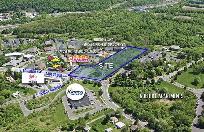
Property Record
1001 E Brighton Ave, Syracuse, NY 13205

Property Detail
1001 E Brighton Ave
311500-062-000-0002-011-000-0000
ONONDAGA
Autorepair
New York
04 - FARM
11.001
B and X Area of moderate flood hazard, usually the area between the limits of the 100-year and 500-year floods.
1.68 AC
2025
SE Outer Onondaga County
2025
Syracuse
006102
Syracuse, NY
1,440 SF
NEARBY LISTINGS FOR SALE OR LEASE
-
-
No Photo
-
-
View all Syracuse listings for sale on LoopNet.com
DEMOGRAPHICS near 1001 E Brighton Ave
1 mile
3 mile
5 mile
2025 Total Population
8,481
74,439
173,934
2030 Population
8,497
74,318
173,022
Pop Growth 2025-2030
+ 0.19%
(0.16%)
(0.52%)
Average Age
43
37
38
2025 Total Households
3,716
26,008
68,581
HH Growth 2025-2030
+ 0.05%
(0.33%)
(0.55%)
Median Household Inc
$49,582
$54,827
$55,446
Avg Household Size
2.00
2.30
2.20
2025 Avg HH Vehicles
1.00
1.00
1.00
Median Home Value
$172,359
$179,065
$179,128
Median Year Built
1969
1955
1952
Nearby Places
Map Layers
Map Styles
 Street
 Aerial
Layers
 Traffic
 Biking
Places
Listings with unknown addresses are not visible on the map
- Restaurants
- Banks
- Shops
- Fitness
- Groceries
PUBLIC TRANSPORTATION
COMMUTER RAIL
Syracuse Regional Transportation Center (Empire Service - Amtrak, Lake Shore Limited - Amtrak, Maple Leaf - Amtrak)
Drive
Walk
Distance
Syracuse Regional Transportation Center (Empire Service - Amtrak, Lake Shore Limited - Amtrak, Maple Leaf - Amtrak)
11 min
6.4 mi
AIRPORT
Syracuse Hancock International
Drive
Walk
Distance
Syracuse Hancock International
17 min
11.0 mi
Freight Ports
Albany, NY Port
Drive
Walk
Distance
Albany, NY Port
176 min
148.0 mi
SALE & LEASE HISTORY
LISTING DATE
SALE/LEASE

Jul 01, 2019
For Sale
Dec 20, 2021
For Sale
Apr 03, 2017
For Lease
Nearby Properties
Address
Land Use
TOTAL SIZE
Lot Size
Zoning
Address
Land Use
TOTAL SIZE
Lot Size
Zoning
70,284 SF
74.57 AC
25
Address
Land Use
TOTAL SIZE
Lot Size
Zoning
459,040 SF
4.71 AC
06 - INDUS
Address
Land Use
TOTAL SIZE
Lot Size
Zoning
12.08 AC
Address
Land Use
TOTAL SIZE
Lot Size
Zoning
826,528 SF
2.28 AC
06 - INDUS
Address
Land Use
TOTAL SIZE
Lot Size
Zoning
269,030 SF
11.90 AC
05 - COMME
Address
Land Use
TOTAL SIZE
Lot Size
Zoning
412,577 SF
39.43 AC
08 - GOVER
Address
Land Use
TOTAL SIZE
Lot Size
Zoning
348,998 SF
65.59 AC
25
Address
Land Use
TOTAL SIZE
Lot Size
Zoning
72,200 SF
12.39 AC
06 - INDUS
Address
Land Use
TOTAL SIZE
Lot Size
Zoning
354,492 SF
6.90 AC
25
Address
Land Use
TOTAL SIZE
Lot Size
Zoning
72,800 SF
1.89 AC
06 - INDUS
Address
Land Use
TOTAL SIZE
Lot Size
Zoning
218,051 SF
2.32 AC
25
Address
Land Use
TOTAL SIZE
Lot Size
Zoning
24,360 SF
3.99 AC
10
Address
Land Use
TOTAL SIZE
Lot Size
Zoning
2,709 SF
39.74 AC
06 - INDUS
Address
Land Use
TOTAL SIZE
Lot Size
Zoning
1.67 AC
06 - INDUS
Address
Land Use
TOTAL SIZE
Lot Size
Zoning
164,837 SF
0.66 AC
10
Address
Land Use
TOTAL SIZE
Lot Size
Zoning
105,004 SF
2.81 AC
25
Address
Land Use
TOTAL SIZE
Lot Size
Zoning
165,800 SF
1.27 AC
25
Address
Land Use
TOTAL SIZE
Lot Size
Zoning
168,000 SF
2.18 AC
06 - INDUS
Address
Land Use
TOTAL SIZE
Lot Size
Zoning
25,646 SF
88.85 AC
02 - SINGL
Address
Land Use
TOTAL SIZE
Lot Size
Zoning
307,860 SF
1.17 AC
25
Address
Land Use
TOTAL SIZE
Lot Size
Zoning
6,400 SF
86.36 AC
06 - INDUS
Address
Land Use
TOTAL SIZE
Lot Size
Zoning
50,472 SF
4.89 AC
10
Address
Land Use
TOTAL SIZE
Lot Size
Zoning
31,947 SF
1.23 AC
Address
Land Use
TOTAL SIZE
Lot Size
Zoning
278,208 SF
1.92 AC
25
Address
Land Use
TOTAL SIZE
Lot Size
Zoning
134,400 SF
1.18 AC
25
Address
Land Use
TOTAL SIZE
Lot Size
Zoning
172,600 SF
3.19 AC
06 - INDUS
Address
Land Use
TOTAL SIZE
Lot Size
Zoning
194,261 SF
2.62 AC
25
Address
Land Use
TOTAL SIZE
Lot Size
Zoning
74,700 SF
3.83 AC
25
Address
Land Use
TOTAL SIZE
Lot Size
Zoning
92,724 SF
2.98 AC
25
Address
Land Use
TOTAL SIZE
Lot Size
Zoning
256,704 SF
3.46 AC
07 - MIXED
The World's #1 Commercial Real Estate Marketplace
Connect with us
© 2026 CoStar Group
The information above has been obtained from sources believed reliable. While we do not doubt its accuracy we have not verified it and make no guarantee, warranty or representation about it. It is your responsibility to independently confirm its accuracy and completeness. Any projections, opinions, assumptions, or estimates used are for example only and do not represent the current or future performance of the property. The value of this transaction to you depends on tax and other factors which should be evaluated by your tax, financial, and legal advisors. You and your advisors should conduct a careful, independent investigation of the property to determine to your satisfaction the suitability of the property for your needs.