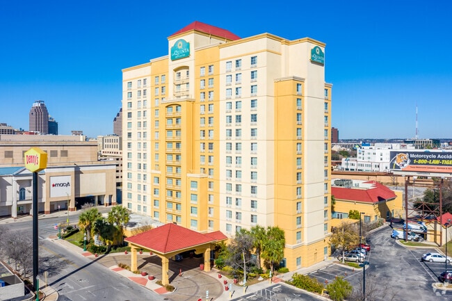
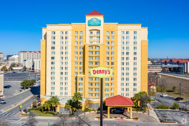
Property Record
1001 E Commerce St, San Antonio, TX 78205
Save to a Folder
{{folder.Name}}
{{folder.ListingIds.length}} Properties
{{folder.ListingIds.length}} Property
Create a New Folder
Property Detail
1001 E Commerce St
San Antonio-New Braunfels, TX
NCB 153 BLK 3 LOT 91 LA QUINTA/CONVENTION CTR SUBD 2013-NEW ACCT PER SPLIT PER CR# 27676
00153-003-0900
BEXAR
Hotel
Texas
B and X Area of moderate flood hazard, usually the area between the limits of the 100-year and 500-year floods.
90
2025
3.29 AC
2025
San Antonio CBD
110100
San Antonio
61,749 SF
NEARBY LISTINGS FOR SALE OR LEASE
DEMOGRAPHICS near 1001 E Commerce St
1 mile
3 mile
5 mile
2025 Total Population
14,018
143,597
357,672
2030 Population
15,251
153,418
377,647
Pop Growth 2025-2030
+ 8.80%
+ 6.84%
+ 5.58%
Average Age
41
38
39
2025 Total Households
7,328
54,910
130,385
HH Growth 2025-2030
+ 9.39%
+ 7.34%
+ 5.91%
Median Household Inc
$58,530
$47,989
$48,658
Avg Household Size
1.80
2.40
2.60
2025 Avg HH Vehicles
1.00
1.00
2.00
Median Home Value
$439,274
$220,762
$177,514
Median Year Built
1997
1955
1957
Nearby Places
Map Layers
Map Styles
 Street
 Aerial
Layers
 Traffic
 Biking
Places
Listings with unknown addresses are not visible on the map
- Restaurants
- Banks
- Shops
- Fitness
- Groceries
PUBLIC TRANSPORTATION
COMMUTER RAIL
San Antonio Amtrak Station (Sunset Limited - Amtrak, Texas Eagle - Amtrak)
Drive
Walk
Distance
San Antonio Amtrak Station (Sunset Limited - Amtrak, Texas Eagle - Amtrak)
2 min
12 min
0.6 mi
AIRPORT
San Antonio International
Drive
Walk
Distance
San Antonio International
11 min
7.9 mi
Freight Ports
Calhoun Port
Drive
Walk
Distance
Calhoun Port
181 min
147.0 mi
Nearby Properties
Address
Land Use
TOTAL SIZE
Lot Size
Zoning
Address
Land Use
TOTAL SIZE
Lot Size
Zoning
2,544.56 AC
Address
Land Use
TOTAL SIZE
Lot Size
Zoning
26.51 AC
Address
Land Use
TOTAL SIZE
Lot Size
Zoning
443,000 SF
4.16 AC
Address
Land Use
TOTAL SIZE
Lot Size
Zoning
738,650 SF
2.93 AC
Address
Land Use
TOTAL SIZE
Lot Size
Zoning
1,049,861 SF
1.50 AC
Address
Land Use
TOTAL SIZE
Lot Size
Zoning
339,590 SF
3.12 AC
Address
Land Use
TOTAL SIZE
Lot Size
Zoning
922,468 SF
10.78 AC
Address
Land Use
TOTAL SIZE
Lot Size
Zoning
21,386 SF
1.03 AC
Address
Land Use
TOTAL SIZE
Lot Size
Zoning
443,560 SF
2.77 AC
Address
Land Use
TOTAL SIZE
Lot Size
Zoning
400,228 SF
0.78 AC
Address
Land Use
TOTAL SIZE
Lot Size
Zoning
290,794 SF
0.62 AC
Address
Land Use
TOTAL SIZE
Lot Size
Zoning
8.10 AC
Address
Land Use
TOTAL SIZE
Lot Size
Zoning
5,106 SF
2.30 AC
Address
Land Use
TOTAL SIZE
Lot Size
Zoning
387,443 SF
0.89 AC
Address
Land Use
TOTAL SIZE
Lot Size
Zoning
43,834 SF
3.11 AC
Address
Land Use
TOTAL SIZE
Lot Size
Zoning
178,534 SF
1.32 AC
Address
Land Use
TOTAL SIZE
Lot Size
Zoning
254,108 SF
2.40 AC
Address
Land Use
TOTAL SIZE
Lot Size
Zoning
103,425 SF
4.76 AC
Address
Land Use
TOTAL SIZE
Lot Size
Zoning
521,935 SF
2.17 AC
Address
Land Use
TOTAL SIZE
Lot Size
Zoning
495,840 SF
1.20 AC
Address
Land Use
TOTAL SIZE
Lot Size
Zoning
308,878 SF
1.23 AC
Address
Land Use
TOTAL SIZE
Lot Size
Zoning
254,908 SF
1.92 AC
Address
Land Use
TOTAL SIZE
Lot Size
Zoning
11,915 SF
4.06 AC
Address
Land Use
TOTAL SIZE
Lot Size
Zoning
173,422 SF
5.85 AC
Address
Land Use
TOTAL SIZE
Lot Size
Zoning
15,468 SF
4.18 AC
Address
Land Use
TOTAL SIZE
Lot Size
Zoning
221,865 SF
3.12 AC
Address
Land Use
TOTAL SIZE
Lot Size
Zoning
262,082 SF
1.60 AC
Address
Land Use
TOTAL SIZE
Lot Size
Zoning
7,018 SF
3.24 AC
Address
Land Use
TOTAL SIZE
Lot Size
Zoning
163,858 SF
0.62 AC
Address
Land Use
TOTAL SIZE
Lot Size
Zoning
481,589 SF
5.29 AC
The World's #1 Commercial Real Estate Marketplace
Connect with us
© 2026 CoStar Group
The information above has been obtained from sources believed reliable. While we do not doubt its accuracy we have not verified it and make no guarantee, warranty or representation about it. It is your responsibility to independently confirm its accuracy and completeness. Any projections, opinions, assumptions, or estimates used are for example only and do not represent the current or future performance of the property. The value of this transaction to you depends on tax and other factors which should be evaluated by your tax, financial, and legal advisors. You and your advisors should conduct a careful, independent investigation of the property to determine to your satisfaction the suitability of the property for your needs.