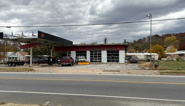
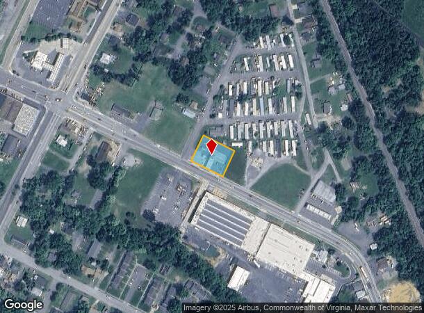
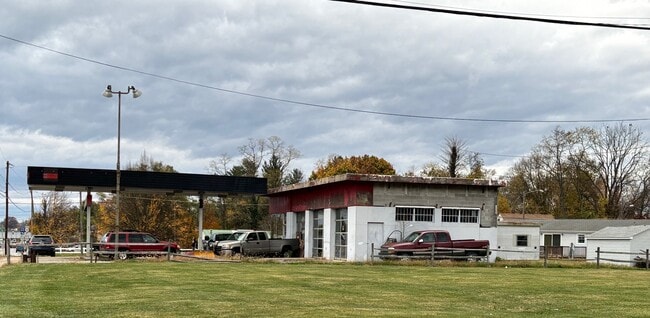
Property Record
1001 E Main St, Waynesboro, VA 22980
NEARBY LISTINGS FOR SALE OR LEASE
Property Detail
1001 E Main St
57-2-24A
PARCEL FRONTING 150' ON MAIN ST ADJ PATCH SMALL ACREAGE
Commercialnec
Waynesboro
X
Virginia
51125C0050C
0.43 AC
2025
Staunton & Harrisonburg
2025
Other Market Areas
003200
Staunton-Waynesboro, VA
1,680 SF
DEMOGRAPHICS near 1001 E Main St
1 Mile
3 Mile
5 Mile
2024 Total Population
5,550
23,334
32,647
2029 Population
6,009
25,081
34,678
Pop Growth 2024-2029
+ 8.27%
+ 7.49%
+ 6.22%
Average Age
39
41
43
2024 Total Households
2,403
10,047
13,909
HH Growth 2024-2029
+ 8.24%
+ 7.47%
+ 6.24%
Median Household Inc
$34,766
$48,131
$54,311
Avg Household Size
2.30
2.30
2.30
2024 Avg HH Vehicles
2.00
2.00
2.00
Median Home Value
$150,549
$199,026
$236,797
Median Year Built
1977
1972
1978
Nearby Places
Map Layers
Map Styles
 Street
 Aerial
- Restaurants
- Banks
- Shops
- Fitness
- Groceries
PUBLIC TRANSPORTATION
AIRPORT
Charlottesville-Albemarle
DRIVE
WALK
Distance
Charlottesville-Albemarle
48 min
33.6 mi
Freight Ports
Virginia Port Authority - Richmond
DRIVE
WALK
Distance
Virginia Port Authority - Richmond
119 min
101.7 mi
SALE & LEASE HISTORY
LISTING DATE
SALE/LEASE

Oct 30, 2023
For Sale
Nearby Properties
Address
Land Use
TOTAL SIZE
Lot Size
Zoning
Address
Land Use
TOTAL SIZE
Lot Size
Zoning
150,944 SF
22.24 AC
RG-5
Address
Land Use
TOTAL SIZE
Lot Size
Zoning
165,670 SF
5.31 AC
R-O
Address
Land Use
TOTAL SIZE
Lot Size
Zoning
25,100 SF
11.54 AC
PUD
Address
Land Use
TOTAL SIZE
Lot Size
Zoning
11,510 SF
8.31 AC
PUD
Address
Land Use
TOTAL SIZE
Lot Size
Zoning
73,371 SF
13.23 AC
H-B
Address
Land Use
TOTAL SIZE
Lot Size
Zoning
2.08 AC
RG-5
Address
Land Use
TOTAL SIZE
Lot Size
Zoning
48,888 SF
9.01 AC
RG-5
Address
Land Use
TOTAL SIZE
Lot Size
Zoning
121,275 SF
18.39 AC
RG-5
Address
Land Use
TOTAL SIZE
Lot Size
Zoning
947 SF
13.62 AC
RG-5
Address
Land Use
TOTAL SIZE
Lot Size
Zoning
29,582 SF
5.36 AC
PUD
Address
Land Use
TOTAL SIZE
Lot Size
Zoning
301,338 SF
21.52 AC
H-I
Address
Land Use
TOTAL SIZE
Lot Size
Zoning
12.01 AC
RS-7
Address
Land Use
TOTAL SIZE
Lot Size
Zoning
5,624 SF
74.80 AC
H-I
Address
Land Use
TOTAL SIZE
Lot Size
Zoning
31,977 SF
5.07 AC
RS-12
Address
Land Use
TOTAL SIZE
Lot Size
Zoning
460 SF
144.09 AC
H-I
Address
Land Use
TOTAL SIZE
Lot Size
Zoning
7,512 SF
6.39 AC
R-MF
Address
Land Use
TOTAL SIZE
Lot Size
Zoning
1,844 SF
8.39 AC
R-MF
Address
Land Use
TOTAL SIZE
Lot Size
Zoning
2,460 SF
31.78 AC
PUD
Address
Land Use
TOTAL SIZE
Lot Size
Zoning
5,108 SF
20.66 AC
RG-5
Address
Land Use
TOTAL SIZE
Lot Size
Zoning
840 SF
1.70 AC
C-B
Address
Land Use
TOTAL SIZE
Lot Size
Zoning
41,574 SF
5.29 AC
H-B
Address
Land Use
TOTAL SIZE
Lot Size
Zoning
2,393 SF
6.81 AC
R-MF
Address
Land Use
TOTAL SIZE
Lot Size
Zoning
7,128 SF
3.75 AC
R-MF
Address
Land Use
TOTAL SIZE
Lot Size
Zoning
62,626 SF
1.15 AC
R-MF
Address
Land Use
TOTAL SIZE
Lot Size
Zoning
54,021 SF
9.74 AC
RS-7
Address
Land Use
TOTAL SIZE
Lot Size
Zoning
36,698 SF
0.90 AC
R-MF
Address
Land Use
TOTAL SIZE
Lot Size
Zoning
1,000 SF
4.17 AC
H-B
Address
Land Use
TOTAL SIZE
Lot Size
Zoning
42,122 SF
8 AC
RG-5
Address
Land Use
TOTAL SIZE
Lot Size
Zoning
106,752 SF
7.76 AC
H-I
Address
Land Use
TOTAL SIZE
Lot Size
Zoning
301,313 SF
55.86 AC
H-I
The World's #1 Commercial Real Estate Marketplace
Connect with us
© 2025 CoStar Group
The information above has been obtained from sources believed reliable. While we do not doubt its accuracy we have not verified it and make no guarantee, warranty or representation about it. It is your responsibility to independently confirm its accuracy and completeness. Any projections, opinions, assumptions, or estimates used are for example only and do not represent the current or future performance of the property. The value of this transaction to you depends on tax and other factors which should be evaluated by your tax, financial, and legal advisors. You and your advisors should conduct a careful, independent investigation of the property to determine to your satisfaction the suitability of the property for your needs.