Property Record
1001 Elberta Rd, Warner Robins, GA 31093
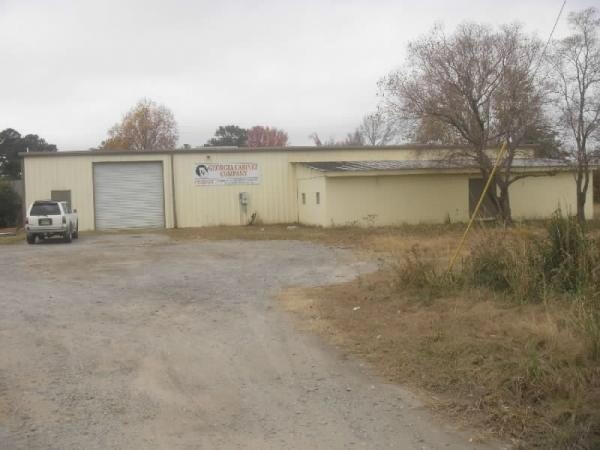

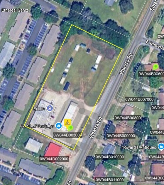
Property Detail
1001 Elberta Rd
0W044D003000
TRACT A 2.02 ACRES 176/5TH
Conveniencestore
Houston
C2
Georgia
B and X Area of moderate flood hazard, usually the area between the limits of the 100-year and 500-year floods.
176
2025
2.02 AC
2025
Perry/Warner Robins
020110
Other Market Areas
5,150 SF
Warner Robins, GA
NEARBY LISTINGS FOR SALE OR LEASE
DEMOGRAPHICS near 1001 Elberta Rd
1 mile
3 mile
5 mile
2025 Total Population
11,362
48,362
90,425
2030 Population
11,903
50,925
95,350
Pop Growth 2025-2030
+ 4.76%
+ 5.30%
+ 5.45%
Average Age
37
38
38
2025 Total Households
4,482
19,260
35,919
HH Growth 2025-2030
+ 4.73%
+ 5.35%
+ 5.50%
Median Household Inc
$45,665
$51,311
$60,996
Avg Household Size
2.40
2.40
2.40
2025 Avg HH Vehicles
2.00
2.00
2.00
Median Home Value
$136,439
$136,668
$165,336
Median Year Built
1974
1975
1985
Nearby Places
Map Layers
Map Styles
 Street
 Aerial
Transit
 Traffic
 Biking
Places
Listings with unknown addresses are not visible on the map
- Restaurants
- Banks
- Shops
- Fitness
- Groceries
Nearby Properties
Address
Land Use
TOTAL SIZE
Lot Size
Zoning
Address
Land Use
TOTAL SIZE
Lot Size
Zoning
88,965 SF
18.72 AC
R2
Address
Land Use
TOTAL SIZE
Lot Size
Zoning
94,820 SF
18.66 AC
C2
Address
Land Use
TOTAL SIZE
Lot Size
Zoning
223,599 SF
22.40 AC
C2
Address
Land Use
TOTAL SIZE
Lot Size
Zoning
11,658 SF
30.23 AC
R2
Address
Land Use
TOTAL SIZE
Lot Size
Zoning
304,246 SF
23.11 AC
C2
Address
Land Use
TOTAL SIZE
Lot Size
Zoning
132,850 SF
24.05 AC
C2
Address
Land Use
TOTAL SIZE
Lot Size
Zoning
234,239 SF
24.71 AC
C2
Address
Land Use
TOTAL SIZE
Lot Size
Zoning
164,700 SF
19.20 AC
R3
Address
Land Use
TOTAL SIZE
Lot Size
Zoning
2,231 SF
11.48 AC
C2
Address
Land Use
TOTAL SIZE
Lot Size
Zoning
23,440 SF
18.96 AC
C2
Address
Land Use
TOTAL SIZE
Lot Size
Zoning
78,270 SF
3.35 AC
C2
Address
Land Use
TOTAL SIZE
Lot Size
Zoning
108,750 SF
10.85 AC
C2
Address
Land Use
TOTAL SIZE
Lot Size
Zoning
1,531 SF
27.16 AC
R4
Address
Land Use
TOTAL SIZE
Lot Size
Zoning
40,284 SF
3.74 AC
C3
Address
Land Use
TOTAL SIZE
Lot Size
Zoning
3,906 SF
12.53 AC
C2
Address
Land Use
TOTAL SIZE
Lot Size
Zoning
67,920 SF
8.28 AC
C2
Address
Land Use
TOTAL SIZE
Lot Size
Zoning
61,628 SF
45 AC
C2
Address
Land Use
TOTAL SIZE
Lot Size
Zoning
49,776 SF
14.03 AC
R4
Address
Land Use
TOTAL SIZE
Lot Size
Zoning
94,798 SF
8.17 AC
R2
Address
Land Use
TOTAL SIZE
Lot Size
Zoning
11,200 SF
7.60 AC
R4
Address
Land Use
TOTAL SIZE
Lot Size
Zoning
3,375 SF
13.72 AC
R4
Address
Land Use
TOTAL SIZE
Lot Size
Zoning
6,220 SF
13.47 AC
R4
Address
Land Use
TOTAL SIZE
Lot Size
Zoning
10,296 SF
16.21 AC
R4
Address
Land Use
TOTAL SIZE
Lot Size
Zoning
3,791 SF
11.71 AC
R4
Address
Land Use
TOTAL SIZE
Lot Size
Zoning
5,220 SF
8.66 AC
C2
Address
Land Use
TOTAL SIZE
Lot Size
Zoning
1,512 SF
309.01 AC
M2
Address
Land Use
TOTAL SIZE
Lot Size
Zoning
71,434 SF
10.58 AC
R2
Address
Land Use
TOTAL SIZE
Lot Size
Zoning
128,540 SF
32.26 AC
R2
Address
Land Use
TOTAL SIZE
Lot Size
Zoning
75,613 SF
11.51 AC
C1
Address
Land Use
TOTAL SIZE
Lot Size
Zoning
90,000 SF
12 AC
R1
The World's #1 Commercial Real Estate Marketplace
Connect with us
© 2026 CoStar Group
The information above has been obtained from sources believed reliable. While we do not doubt its accuracy we have not verified it and make no guarantee, warranty or representation about it. It is your responsibility to independently confirm its accuracy and completeness. Any projections, opinions, assumptions, or estimates used are for example only and do not represent the current or future performance of the property. The value of this transaction to you depends on tax and other factors which should be evaluated by your tax, financial, and legal advisors. You and your advisors should conduct a careful, independent investigation of the property to determine to your satisfaction the suitability of the property for your needs.