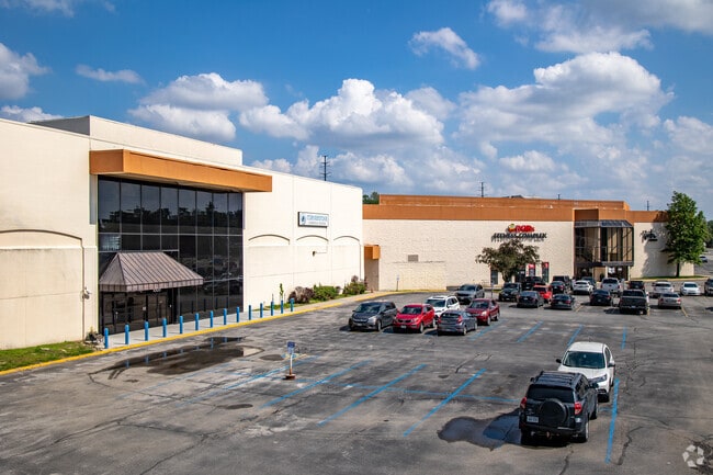
Property Record
1001 Fort Crook Rd N, Bellevue, NE 68005
Current Lease Availabilities
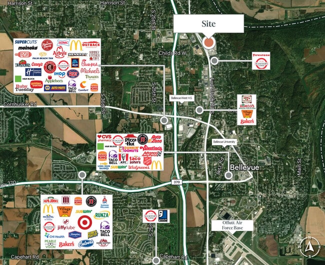
NEARBY LISTINGS FOR SALE OR LEASE
Property Detail
1001 Fort Crook Rd N
011604930
Southroads Technology Park Condominium
Commercialnec
UNIT 4 SOUTHROADS TECHNOLOGY PARK CONDOMINIUM REGIME (45.92%)
X
Sarpy
31153C0095G
Nebraska
2024
11.74 AC
2025
Sarpy East
010104
Omaha/Council Bluffs
141,902 SF
Omaha-Council Bluffs, NE-IA
DEMOGRAPHICS near 1001 Fort Crook Rd N
1 Mile
3 Mile
5 Mile
2024 Total Population
5,106
56,833
147,486
2029 Population
5,499
59,653
153,861
Pop Growth 2024-2029
+ 7.70%
+ 4.96%
+ 4.32%
Average Age
36
36
37
2024 Total Households
1,860
20,130
53,543
HH Growth 2024-2029
+ 7.80%
+ 5.43%
+ 4.60%
Median Household Inc
$71,458
$60,071
$62,107
Avg Household Size
2.60
2.70
2.60
2024 Avg HH Vehicles
2.00
2.00
2.00
Median Home Value
$202,116
$173,489
$180,763
Median Year Built
1974
1968
1969
Nearby Places
- Restaurants
- Banks
- Shops
- Fitness
- Groceries
PUBLIC TRANSPORTATION
COMMUTER RAIL
Omaha Amtrak Station (California Zephyr - Amtrak)
DRIVE
WALK
Distance
Omaha Amtrak Station (California Zephyr - Amtrak)
10 min
5.3 mi
Omaha Amtrak Station (California Zephyr - Amtrak)
DRIVE
WALK
Distance
Omaha Amtrak Station (California Zephyr - Amtrak)
10 min
5.4 mi
AIRPORT
Eppley Airfield
DRIVE
WALK
Distance
Eppley Airfield
20 min
11.0 mi
Freight Ports
Tulsa Port Of Catoosa
DRIVE
WALK
Distance
Tulsa Port Of Catoosa
457 min
413.7 mi
Nearby Properties
Address
Land Use
TOTAL SIZE
Lot Size
Zoning
Address
Land Use
TOTAL SIZE
Lot Size
Zoning
276,509 SF
3.67 AC
Address
Land Use
TOTAL SIZE
Lot Size
Zoning
10,052 SF
9.38 AC
Address
Land Use
TOTAL SIZE
Lot Size
Zoning
160,000 SF
22.48 AC
Address
Land Use
TOTAL SIZE
Lot Size
Zoning
254,734 SF
18.90 AC
Address
Land Use
TOTAL SIZE
Lot Size
Zoning
1,216 SF
22.82 AC
Address
Land Use
TOTAL SIZE
Lot Size
Zoning
18,825 SF
15.18 AC
Address
Land Use
TOTAL SIZE
Lot Size
Zoning
12.71 AC
Address
Land Use
TOTAL SIZE
Lot Size
Zoning
119,396 SF
13.46 AC
Address
Land Use
TOTAL SIZE
Lot Size
Zoning
226,320 SF
12.75 AC
Address
Land Use
TOTAL SIZE
Lot Size
Zoning
3.95 AC
Address
Land Use
TOTAL SIZE
Lot Size
Zoning
1,850 SF
8.14 AC
Address
Land Use
TOTAL SIZE
Lot Size
Zoning
400 SF
23.26 AC
Address
Land Use
TOTAL SIZE
Lot Size
Zoning
42,900 SF
16.25 AC
Address
Land Use
TOTAL SIZE
Lot Size
Zoning
2,032 SF
8.67 AC
Address
Land Use
TOTAL SIZE
Lot Size
Zoning
212,990 SF
8.75 AC
MH
Address
Land Use
TOTAL SIZE
Lot Size
Zoning
1,103 SF
9.27 AC
Address
Land Use
TOTAL SIZE
Lot Size
Zoning
236,067 SF
10.12 AC
HI
Address
Land Use
TOTAL SIZE
Lot Size
Zoning
33,713 SF
14.39 AC
Address
Land Use
TOTAL SIZE
Lot Size
Zoning
63,669 SF
6.58 AC
Address
Land Use
TOTAL SIZE
Lot Size
Zoning
4.53 AC
Address
Land Use
TOTAL SIZE
Lot Size
Zoning
18,752 SF
7.06 AC
Address
Land Use
TOTAL SIZE
Lot Size
Zoning
2,328 SF
6.18 AC
Address
Land Use
TOTAL SIZE
Lot Size
Zoning
3,418 SF
5.56 AC
Address
Land Use
TOTAL SIZE
Lot Size
Zoning
230,995 SF
11.29 AC
HI
Address
Land Use
TOTAL SIZE
Lot Size
Zoning
3.41 AC
A-P
Address
Land Use
TOTAL SIZE
Lot Size
Zoning
131,549 SF
6.13 AC
Address
Land Use
TOTAL SIZE
Lot Size
Zoning
252,694 SF
17.74 AC
HI
Address
Land Use
TOTAL SIZE
Lot Size
Zoning
161,765 SF
18.32 AC
Address
Land Use
TOTAL SIZE
Lot Size
Zoning
38,595 SF
2.07 AC
Address
Land Use
TOTAL SIZE
Lot Size
Zoning
74,586 SF
4.24 AC
The World's #1 Commercial Real Estate Marketplace
Connect with us
© 2025 CoStar Group
The information above has been obtained from sources believed reliable. While we do not doubt its accuracy we have not verified it and make no guarantee, warranty or representation about it. It is your responsibility to independently confirm its accuracy and completeness. Any projections, opinions, assumptions, or estimates used are for example only and do not represent the current or future performance of the property. The value of this transaction to you depends on tax and other factors which should be evaluated by your tax, financial, and legal advisors. You and your advisors should conduct a careful, independent investigation of the property to determine to your satisfaction the suitability of the property for your needs.