Property Record
1001 Frank H St, Waunakee, WI 53597


NEARBY LISTINGS FOR SALE OR LEASE
-
-
View all Waunakee listings for sale on LoopNet.com
Property Detail
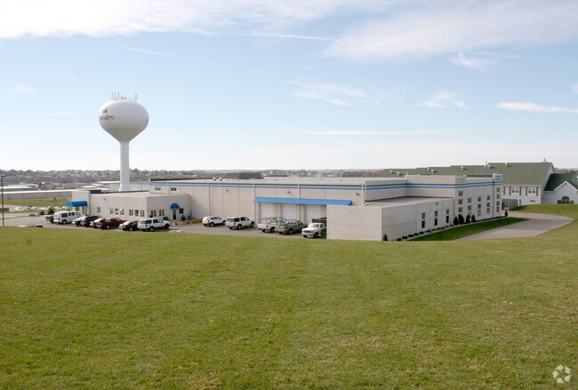
1001 Frank H St
Madison, WI
Certified Surv Map 10641
0809-092-0010-1
LOT 1 CSM 10641 CS63/122&124-1/7/2003 F/K/A LOTS 1 CSM 10186 CS59/296&297-9/26/2 001 F/K/A WAUNAKEE BUSINESS PARK LOT 1 DESCR AS SEC 9-8-9 PRT NE1/4NW1/4 (5.00 A CRES)
Commercialnec
Dane
X
Wisconsin
55025C0233H
1
2024
5 AC
2024
Outlying Dane West
011302
Milwaukee/Madison
DEMOGRAPHICS near 1001 Frank H St
1 Mile
3 Mile
5 Mile
2024 Total Population
3,079
17,744
35,128
2029 Population
3,199
18,418
36,440
Pop Growth 2024-2029
+ 3.90%
+ 3.80%
+ 3.73%
Average Age
40
40
41
2024 Total Households
1,247
6,480
13,576
HH Growth 2024-2029
+ 3.85%
+ 3.78%
+ 3.79%
Median Household Inc
$91,951
$120,319
$96,599
Avg Household Size
2.40
2.70
2.50
2024 Avg HH Vehicles
2.00
2.00
2.00
Median Home Value
$362,499
$421,594
$366,254
Median Year Built
1990
1994
1989
Nearby Places
Map Layers
Map Styles
 Street
 Aerial
- Restaurants
- Banks
- Shops
- Fitness
- Groceries
PUBLIC TRANSPORTATION
AIRPORT
Dane County Regional/Truax Field
DRIVE
WALK
Distance
Dane County Regional/Truax Field
15 min
8.4 mi
Nearby Properties
Address
Land Use
TOTAL SIZE
Lot Size
Zoning
Address
Land Use
TOTAL SIZE
Lot Size
Zoning
11,856 SF
0.61 AC
PD
Address
Land Use
TOTAL SIZE
Lot Size
Zoning
7.63 AC
Address
Land Use
TOTAL SIZE
Lot Size
Zoning
2.17 AC
Address
Land Use
TOTAL SIZE
Lot Size
Zoning
14.13 AC
Address
Land Use
TOTAL SIZE
Lot Size
Zoning
3.54 AC
Address
Land Use
TOTAL SIZE
Lot Size
Zoning
6.47 AC
Address
Land Use
TOTAL SIZE
Lot Size
Zoning
Address
Land Use
TOTAL SIZE
Lot Size
Zoning
13.94 AC
Address
Land Use
TOTAL SIZE
Lot Size
Zoning
47.35 AC
Address
Land Use
TOTAL SIZE
Lot Size
Zoning
2.23 AC
Address
Land Use
TOTAL SIZE
Lot Size
Zoning
2.24 AC
Address
Land Use
TOTAL SIZE
Lot Size
Zoning
14.30 AC
Address
Land Use
TOTAL SIZE
Lot Size
Zoning
Address
Land Use
TOTAL SIZE
Lot Size
Zoning
6.23 AC
Address
Land Use
TOTAL SIZE
Lot Size
Zoning
1.73 AC
Address
Land Use
TOTAL SIZE
Lot Size
Zoning
5.62 AC
Address
Land Use
TOTAL SIZE
Lot Size
Zoning
27.60 AC
ETZ
Address
Land Use
TOTAL SIZE
Lot Size
Zoning
Address
Land Use
TOTAL SIZE
Lot Size
Zoning
Address
Land Use
TOTAL SIZE
Lot Size
Zoning
8.82 AC
Address
Land Use
TOTAL SIZE
Lot Size
Zoning
Address
Land Use
TOTAL SIZE
Lot Size
Zoning
10.35 AC
Address
Land Use
TOTAL SIZE
Lot Size
Zoning
1.39 AC
Address
Land Use
TOTAL SIZE
Lot Size
Zoning
2.45 AC
Address
Land Use
TOTAL SIZE
Lot Size
Zoning
1.58 AC
Address
Land Use
TOTAL SIZE
Lot Size
Zoning
0.90 AC
Address
Land Use
TOTAL SIZE
Lot Size
Zoning
Address
Land Use
TOTAL SIZE
Lot Size
Zoning
1.27 AC
Address
Land Use
TOTAL SIZE
Lot Size
Zoning
4.12 AC
The World's #1 Commercial Real Estate Marketplace
Connect with us
© 2025 CoStar Group
The information above has been obtained from sources believed reliable. While we do not doubt its accuracy we have not verified it and make no guarantee, warranty or representation about it. It is your responsibility to independently confirm its accuracy and completeness. Any projections, opinions, assumptions, or estimates used are for example only and do not represent the current or future performance of the property. The value of this transaction to you depends on tax and other factors which should be evaluated by your tax, financial, and legal advisors. You and your advisors should conduct a careful, independent investigation of the property to determine to your satisfaction the suitability of the property for your needs.